କୋବ୍ୱୁର୍
ଦେଖଣା
Kovvur
కొవ్వూరు | |
|---|---|
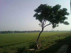
 View of paddy fields near Kovvur from train | |
| ଦେଶ | India |
| ରାଜ୍ୟ | Andhra Pradesh |
| ଜିଲ୍ଲା | West Godavari |
| Mandal | Kovvur |
| Government | |
| • Type | Municipal council |
| • Body | Kovvur Municipality |
| • MLA | Kothapalli Samuel Jawahar (Telugu Desam Party) |
| Area | |
| • ସମୁଦାୟ | 24.56 km2 (9.48 sq mi) |
| Elevation | 9 m (30 ft) |
| Population (2011)[୩] | |
| • Total | ୩୯,୬୬୭ |
| • Density | 1,600/km2 (4,200/sq mi) |
| ଭାଷା | |
| • ସରକାରୀ | Telugu |
| Time zone | UTC+5:30 (IST) |
| PIN | 534 350 |
| Telephone code | +91–8813 |
କୋବ୍ୱୁର୍ ଏକ ଭାରତୀୟ ନଗର ପଞ୍ଚାୟତ ଅଟେ । ଏହା ଆନ୍ଧ୍ର ପ୍ରଦେଶର ୱେସ୍ତ୍ ଗୋଦବରି ଜିଲ୍ଲାରେ ଅବସ୍ଥିତ ।
ଭୌଗଳିକ ଅବସ୍ଥିତି
[ସମ୍ପାଦନା]କୋବ୍ୱୁର୍ ୧୭.୦୧୬୨ ଉତ୍ତର ଅକ୍ଷାଂଶ ଓ ୮୧.୭୨୯୩ ପୂର୍ବ ଦ୍ରାଘିମାରେ ଅବସ୍ଥିତ । ସମୁଦ୍ର ପତନଠାରୁ ଏହା ୩୬ ଫୁଟ ଉଚ୍ଚତାରେ ରହିଛି ।[୪]
ଜନସଂଖ୍ୟା ଓ ସାକ୍ଷରତା
[ସମ୍ପାଦନା]୨୦୦୧ ମସିହାର ଭାରତୀୟ ଜନଗଣନା ଅନୁସାରେ, କୋବ୍ୱୁର୍ ସହରର ମୋଟ ଜନସଂଖ୍ୟା ୩୯୧୯୩ ଅଟେ ।[୫] ସେଥି ମଧ୍ୟରୁ ୪୯.୮୨% ଜଣ ପରୁଷ ହୋଇଥିବା ବେଳେ ୫୦.୧୮% ଜଣ ନାରୀ ଅଟନ୍ତି । କୋବ୍ୱୁର୍ର ସାକ୍ଷରତା ହାର ୭୦.୨୬% ଅଟେ । ଏହା ଜାତୀୟ ହାରଠାରୁ ୫.୪୨% ପ୍ରତିଶତ କମ ଅଟେ । ସେଥିରୁ ୩୭.୦୫% ପ୍ରତିଶତ ପୁରୁଷ ଓ ୩୩.୨୦% ନାରୀ ଅଟନ୍ତି । ୧୦.୫୪% ଲୋକ ସେଠାରେ ୬ ବର୍ଷ ବୟସରୁ କମ ବୟସ୍କ ଅଟନ୍ତି ।[୫]
ଭାଷା
[ସମ୍ପାଦନା]ତେଲୁଗୁ କୋବ୍ୱୁର୍ର ସରକାରୀ ଭାଷା ଅଟେ ।
ଆହୁରି ପଢନ୍ତୁ
[ସମ୍ପାଦନା]ଆଧାର
[ସମ୍ପାଦନା]- ↑ "General Information of The Town". Directorate of Town and Country Planning. Government of Andhra Pradesh. Archived from the original on 21 July 2015. Retrieved 19 July 2015.
- ↑ "Elevation for Kovvur". Veloroutes. Retrieved 19 July 2015.
- ↑ "Census 2011". The Registrar General & Census Commissioner, India. Retrieved 12 August 2014.
- ↑ "Directory of Cities, Towns, and Regions in India". Retrieved 27 September 2015.
- ↑ ୫.୦ ୫.୧ "way back machine - ସେନ୍ସସ୍ ଓଫ୍ ଇଣ୍ଡିଆ". Archived from the original on 16 June 2004. Retrieved 24 September 2015.
