ଅନନ୍ତପୁର
Anantapur
అనంతపురం | |
|---|---|
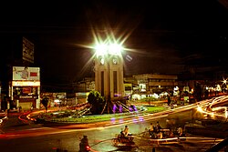
 Clock tower at Anantapur | |
| Country | India |
| State | Andhra Pradesh |
| Region | Rayalaseema |
| District | Anantapur |
| Area | |
| • City | 47.50 km2 (18.34 sq mi) |
| Elevation | 335 m (1,099 ft) |
| Population (2011)[୨] | |
| • City | ୨,୬୮,୫୦୩ |
| • Density | 5,700/km2 (15,000/sq mi) |
| • Metro | ୩,୪୦,୬୧୩ |
| Languages | |
| • Official | Telugu |
| Time zone | UTC+5:30 (IST) |
| PIN | 515001 |
| Telephone code | +91–8554 |
| ଯାନବାହାନ ପଞ୍ଚୀକରଣ | AP–02 |
| Website | Anantapur Municipal Corporation |
ଅନନ୍ତପୁର ଏକ ଭାରତୀୟ ପୌରପାଳିକା (ମ୍ୟୁନିସିପାଲିଟି) ଅଟେ । ଏହା ଆନ୍ଧ୍ର ପ୍ରଦେଶର ଆନନ୍ତପୁର୍ ଜିଲ୍ଲାରେ ଅବସ୍ଥିତ ।
ଭୌଗଳିକ ଅବସ୍ଥିତି
[ସମ୍ପାଦନା]ଅନନ୍ତପୁର ୧୪.୬୭୯୪ ଉତ୍ତର ଅକ୍ଷାଂଶ ଓ ୭୭.୫୯୮୮ ପୂର୍ବ ଦ୍ରାଘିମାରେ ଅବସ୍ଥିତ । ସମୁଦ୍ର ପତନଠାରୁ ଏହା ୧୦୯୯ ଫୁଟ ଉଚ୍ଚତାରେ ରହିଛି ।[୪]
ଜନସଂଖ୍ୟା ଓ ସାକ୍ଷରତା
[ସମ୍ପାଦନା]୨୦୦୧ ମସିହାର ଭାରତୀୟ ଜନଗଣନା ଅନୁସାରେ, ଅନନ୍ତପୁର ସହରର ମୋଟ ଜନସଂଖ୍ୟା ୨୨୦୯୫୧ ଅଟେ ।[୫] ସେଥି ମଧ୍ୟରୁ ୫୦.୮୧% ଜଣ ପରୁଷ ହୋଇଥିବା ବେଳେ ୪୯.୧୯% ଜଣ ନାରୀ ଅଟନ୍ତି । ଅନନ୍ତପୁରର ସାକ୍ଷରତା ହାର ୬୯.୨୯% ଅଟେ । ଏହା ଜାତୀୟ ହାରଠାରୁ -୪.୪୫% ପ୍ରତିଶତ କମ ଅଟେ । ସେଥିରୁ ୩୯.୦୨% ପ୍ରତିଶତ ପୁରୁଷ ଓ ୩୦.୨୭% ନାରୀ ଅଟନ୍ତି । ୧୦.୨୫% ଲୋକ ସେଠାରେ ୬ ବର୍ଷ ବୟସରୁ କମ ବୟସ୍କ ଅଟନ୍ତି ।[୫]
ଭାଷା
[ସମ୍ପାଦନା]ତେଲୁଗୁ ଅନନ୍ତପୁରର ସରକାରୀ ଭାଷା ଅଟେ ।
ପାଣିପାଗ
[ସମ୍ପାଦନା]| Anantapur | ||||||||||||||||||||||||||||||||||||||||||||||||||||||||||||
|---|---|---|---|---|---|---|---|---|---|---|---|---|---|---|---|---|---|---|---|---|---|---|---|---|---|---|---|---|---|---|---|---|---|---|---|---|---|---|---|---|---|---|---|---|---|---|---|---|---|---|---|---|---|---|---|---|---|---|---|---|
| Climate chart (explanation) | ||||||||||||||||||||||||||||||||||||||||||||||||||||||||||||
| ||||||||||||||||||||||||||||||||||||||||||||||||||||||||||||
| ||||||||||||||||||||||||||||||||||||||||||||||||||||||||||||
ପ୍ରାୟତଃ ଭାରତୀୟ ସହର ଗୁଡ଼ିକ ଗ୍ରୀଷ୍ମ ମଣ୍ଡଳୀୟ ହୋଇଥାନ୍ତି । ଅନନ୍ତପୁରରେ ବାର୍ଷିକ ସର୍ବାଧିକ ହାରାହାରି ତାପମାତ୍ରା ୩୩.୯ ଡିଗ୍ରୀ ସେଣ୍ଟିଗ୍ରେଡ ଅନୁଭୂତ ହେଉଥିବା ବେଳେ ସର୍ବନିମ୍ନ ହାରାହାରି ତାପମାତ୍ରା ୨୨.୫ ଡିଗ୍ରୀ ସେଣ୍ଟିଗ୍ରେଡ ଅଟେ । ଏଠାରେ ବାର୍ଷିକ ହାରାହାରି ବୃଷ୍ଟିପାତ ୫୪୯ mm/inches ହୋଇଥାଏ ।
| Climate data for Anantapur, ଭାରତ (୧୯୭୧–୨୦୦୦) | |||||||||||||
|---|---|---|---|---|---|---|---|---|---|---|---|---|---|
| Month | Jan | Feb | Mar | Apr | May | Jun | Jul | Aug | Sep | Oct | Nov | Dec | Year |
| ହାରାହାରି ସର୍ବାଧିକ °C (°F) | 30.6 (87.1) |
33.9 (93) |
37.3 (99.1) |
39.3 (102.7) |
39.2 (102.6) |
35.6 (96.1) |
33.7 (92.7) |
33 (91) |
33.1 (91.6) |
31.8 (89.2) |
30.2 (86.4) |
29.2 (84.6) |
33.9 (93) |
| ହାରାହାରି ସର୍ବନିମ୍ନ °C (°F) | 17.4 (63.3) |
19.8 (67.6) |
22.6 (72.7) |
26 (79) |
26.3 (79.3) |
25 (77) |
24.3 (75.7) |
23.9 (75) |
23.5 (74.3) |
22.6 (72.7) |
20.3 (68.5) |
18 (64) |
22.5 (72.5) |
| Average rainfall mm (inches) | 1.2 (0.047) |
0.8 (0.031) |
5.1 (0.201) |
16.7 (0.657) |
42.7 (1.681) |
53.5 (2.106) |
56.7 (2.232) |
77.9 (3.067) |
136.7 (5.382) |
106.9 (4.209) |
41.4 (1.63) |
9.2 (0.362) |
549 (21.61) |
| ହାରାହାରି ମେଘାତ୍ସନ ଦିବସ | 0.1 | 0.1 | 0.4 | 1.2 | 2.6 | 3.3 | 4.2 | 5.2 | 7 | 6.6 | 3 | 0.5 | 34.3 |
| ହାରାହାରି ବିଜୁଳି ଘଡ଼ଘଡ଼ି ମାରୁଥିବା ଦିବସ | 0 | 0 | 0.7 | 2.8 | 5.7 | 3.2 | 1.4 | 2 | 6.1 | 4 | 0.6 | 0 | 26.4
|
| ହାରାହାରି କୁହୁଡ଼ି ଘେରା ଦିବସ | 0 | 0 | 0 | 0 | 0 | 0 | 0 | 0 | 0 | 0 | 0.1 | 0.3 | 0.5 |
| Source: India Meteorological Department (temperatures and precipitation)[୭][୮] | |||||||||||||
ଆହୁରି ପଢନ୍ତୁ
[ସମ୍ପାଦନା]ଆଧାର
[ସମ୍ପାଦନା]- ↑ "Andhra Pradesh Municipal Development Project" (PDF). Municipal Development Project(MDP) Web Site of Government of Andhra Pradesh. p. 2. Retrieved 18 May 2015.[permanent dead link]
- ↑ "Basic Information of Municipality". Municipal Administration & Urban Development Department. Retrieved 25 July 2014.
- ↑ "Major Agglomerations". Citypopulation.de. Retrieved 18 September 2015.
- ↑ "Directory of Cities, Towns, and Regions in India". Retrieved 27 September 2015.
- ↑ ୫.୦ ୫.୧ "way back machine - ସେନ୍ସସ୍ ଓଫ୍ ଇଣ୍ଡିଆ". Archived from the original on 16 June 2004. Retrieved 24 September 2015.
- ↑ "World Weather Information Service -Anantapur". Worldweather.wmo.int. 5 October 2006. Retrieved 28 June 2015.
- ↑ "Chennai- Climatological Information". India Meteorological Department. Retrieved 29 May 2014.
- ↑ India Meteorological Department. "Ever Recorded Maximum Temperature, Minimum Temperature and 24 Hours Heaviest Rainfall up to 2010" (PDF). India Meteorological Department, Pune. Archived from the original (PDF) on 7 August 2017. Retrieved 29 May 2014.
