
ଫାଇଲ:DETAIL VIEW OF MODIFIED WARREN TRUSS WITH VERTICALS. - Union Station Viaduct, Spanning Gaspee, Francis, Promenade and Canal Streets, Providence, Providence County, RI HAER RI,4-PROV,179-12.tif

Size of this JPG preview of this TIF file: ୭୪୭ × ୫୯୯ ପିକ୍ସେଲ. ବାକି ରେଜୋଲୁସନ: ୨୯୯ × ୨୪୦ ପିକ୍ସେଲ | ୫୯୮ × ୪୮୦ ପିକ୍ସେଲ | ୯୫୭ × ୭୬୮ ପିକ୍ସେଲ | ୧,୨୭୭ × ୧,୦୨୪ ପିକ୍ସେଲ | ୨,୫୫୩ × ୨,୦୪୮ ପିକ୍ସେଲ | ୪,୮୬୪ × ୩,୯୦୨ ପିକ୍ସେଲ.
ମୂଳ ଫାଇଲ (୪,୮୬୪ × ୩,୯୦୨ ପିକସେଲ, ଫାଇଲ ଆକାର: ୧୮.୧ MB, ଏମ.ଆଇ.ଏମ.ଇର ପ୍ରକାର: image/tiff)
This is a file from the Wikimedia Commons. Information from its description page there is shown below. |
ସାରକଥା
| DETAIL VIEW OF MODIFIED WARREN TRUSS WITH VERTICALS. - Union Station Viaduct, Spanning Gaspee, Francis, Promenade and Canal Streets, Providence, Providence County, RI | ||||
|---|---|---|---|---|
| ନାମ |
DETAIL VIEW OF MODIFIED WARREN TRUSS WITH VERTICALS. - Union Station Viaduct, Spanning Gaspee, Francis, Promenade and Canal Streets, Providence, Providence County, RI |
|||
| ବିବରଣୀ |
AMTRAK; New York, New Haven, and Hartford Railroad; Gagel, Edward; Federal Railroad Administration; DeLeuw, Cather, Parsons, contractor; Clement, Dan, transmitter; Owens, William, photographer; Barrett, William E, photographer |
|||
| Depicted place | Rhode Island; Providence County; Providence | |||
| ତାରିଖ | Documentation compiled after 1968 | |||
| ମାପ | 4 x 5 in. | |||
| ଏବେକାର ଅବସ୍ଥିତି |
Library of Congress Prints and Photographs Division Washington, D.C. 20540 USA http://hdl.loc.gov/loc.pnp/pp.print |
|||
| ଯୋଜନ ସଂଖ୍ୟା |
HAER RI,4-PROV,179-12 |
|||
| ଶ୍ରେୟ ଧାଡ଼ି |
|
|||
| ଟୀକା |
|
|||
| ମୂଳାଧାର | https://www.loc.gov/pictures/item/ri0360.photos.145777p | |||
| ଅନୁମତି (ଏହି ଫାଇଲକୁ ପୁଣି ବ୍ୟବହାର କରିବେ) |
|
|||

| Object location | | View this and other nearby images on: OpenStreetMap |
|---|
ଫାଇଲ ଇତିହାସ
ଏହା ଫାଇଲଟି ସେତେବେଳେ ଯେମିତି ଦିଶୁଥିଲା ତାହା ଦେଖିବା ପାଇଁ ତାରିଖ/ବେଳା ଉପରେ କ୍ଲିକ କରନ୍ତୁ
| ତାରିଖ/ବେଳ | ନଖ ଦେଖଣା | ଆକାର | ବ୍ୟବହାରକାରୀ | ମତାମତ | |
|---|---|---|---|---|---|
| ଏବେକାର | ୦୨:୪୫, ୨ ଅଗଷ୍ଟ ୨୦୧୪ | 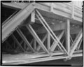 | ୪,୮୬୪ × ୩,୯୦୨ (୧୮.୧ MB) | Fæ | GWToolset: Creating mediafile for Fæ. HABS 31 July 2014 (3000:3200) |
ଫାଇଲ ବ୍ୟବହାର
ଏହି ସବୁପୃଷ୍ଠା ଏହି ଫାଇଲଟିକୁ ଯୋଡ଼ିଥାନ୍ତି:
ଜଗତ ଫାଇଲ ବ୍ୟବହାର
ତଳଲିଖିତ ଉଇକିସବୁ ଏହି ଫାଇଲଟିକୁ ବ୍ୟବହାର କରିଥାନ୍ତି:
- en.wikipedia.orgରେ ବ୍ୟବହାର
- id.wikipedia.orgରେ ବ୍ୟବହାର