
କୋକୋସ୍ (କୀଲିଙ୍ଗ୍) ଦ୍ୱୀପପୁଞ୍ଜ
Territory of the Cocos (Keeling) Islands | |
|---|---|
_Islands.svg) Flag | |
 | |
| ରାଜଧାନୀ | West Island |
| ବୃହତ୍ତମ ସହର | Bantam (Home Island) |
| ସରକାରୀ ଭାଷା | English (de facto) |
| ଜାତୀୟତା |
|
| Government | Federal constitutional monarchy |
• Monarch | Elizabeth II |
Sir Peter Cosgrove | |
• Administrator | Jon Stanhope |
| Aindil Minkom | |
| Territory of Australia | |
• Annexed by British Empire | 1857 |
• Transferred to Australian control | 1955 |
| କ୍ଷେତ୍ରଫଳ | |
• ମୋଟ | 14 km2 (5.4 sq mi) |
• ଜଳଭାଗ (%) | 0 |
| ଲୋକସଂଖ୍ୟା | |
• July 2009 estimate | 596[୧] (241) |
• ଘନତା | 43/km2 (111.4/sq mi) (n/a) |
| ମୁଦ୍ରା | Australian dollar (AUD) |
| ସମୟ ମଣ୍ଡଳ | UTC+06:30 (CCT) |
| ଟେଲିଫୋନ କୋଡ଼ | 61 891 |
| Internet TLD | .cc |
Lua error in ମଡ୍ୟୁଲ:Location_map at line 522: Unable to find the specified location map definition: "Module:Location map/data/Indian Ocean" does not exist.
କୋକୋସ୍ ଦ୍ୱୀପପୁଞ୍ଜ ବା କୀଲିଙ୍ଗ ଦ୍ୱୀପପୁଞ୍ଜ ଏକ ଅଷ୍ଟ୍ରେଲିୟ କ୍ଷେତ୍ର ଅଟେ । ଏହା ପ୍ରାୟତଃ ଶ୍ରୀଲଙ୍କା ଓ ଅଷ୍ଟ୍ରେଲିଆ ମଝି ରାସ୍ତାରେ ଅବସ୍ଥିତ ।
ସରକାର
[ସମ୍ପାଦନା]ଭୂଗୋଳ
[ସମ୍ପାଦନା]ଇତିହାସ
[ସମ୍ପାଦନା]ଅର୍ଥନୀତି
[ସମ୍ପାଦନା]ଗ୍ୟାଲେରି
[ସମ୍ପାଦନା]-
 H.M. Queen Elizabeth and Prince Philip arrive at the Cocos Islands, April 1954.
 -
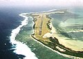 Aerial view of Cocos (Keeling) Islands Airport (ICAO code: YPCC).
 -
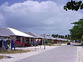 Home Island.
 -
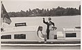 Prince Philip waves goodbye as he and Queen Elizabeth, accompanied by John Clunies Ross, return to their ship from Home Island (1954).
 -
 H.M. Queen Elizabeth at a garden party held in her honour at Home Island.
 -
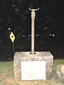 Compass stand from the bridge of HMAS Sydney, which destroyed the SMS Emden, installed at Port Macquarie, New South Wales, in 1929.
 -
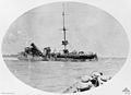 A broadside view of the wrecked German raider Emden after her encounter with HMAS Sydney near Cocos Island. Seamen, shortly to be rescued by the Sydney, crowd together on the clear end of the vessel. In the foreground, several crew members look on from the Sydney 's foredeck.
 -
![The last bombing raid of World War II by 99, 356 and 321 Squadrons is cancelled, 15 August 1945.[୨]](//upload.wikimedia.org/wikipedia/commons/thumb/4/4f/BRIG_DURRANT_WRITING_CANCELLED.jpg/120px-BRIG_DURRANT_WRITING_CANCELLED.jpg) The last bombing raid of World War II by 99, 356 and 321 Squadrons is cancelled, 15 August 1945.[୨]
The last bombing raid of World War II by 99, 356 and 321 Squadrons is cancelled, 15 August 1945.[୨]

_Islands_Airport_-_RWY33.jpg)
Islands_HomeIsland02.jpg)


![The last bombing raid of World War II by 99, 356 and 321 Squadrons is cancelled, 15 August 1945.[୨]](/wiki/%E0%AC%AB%E0%AC%BE%E0%AC%87%E0%AC%B2:BRIG_DURRANT_WRITING_CANCELLED.jpg)
ଆଧାର
[ସମ୍ପାଦନା]- ↑ "Cocos (Keeling) Islands". The World Factbook. CIA. Archived from the original on 10 January 2019. Retrieved 27 January 2012.
- ↑ Maj-General J. T. Durrant (SA Air Force, Commanding Officer, Cocos Islands), watched by Wing Commander "Sandy" Webster (Commanding Officer, 99 Squadron), Squadron Leader Les Evans (Acting Commanding Officer, 356 Squadron) and Lieutenant Commander W. van Prooijen (Commanding Officer, 321 Squadron).
ବାହାର ଲିଙ୍କ
[ସମ୍ପାଦନା]ଉଇକିମିଡ଼ିଆ କମନ୍ସରେ Cocos (Keeling) Islands
ବାବଦରେ ମାଧ୍ୟମ ରହିଛି ।
- Shire of Cocos (Keeling) Islands homepage
- Areas of individual islets Archived 2006-09-13 at the Wayback Machine.
- Atoll Research Bulletin vol. 403 Archived 2006-09-12 at the Wayback Machine.
- Cocos (Keeling) Islands Tourism website
- Noel Crusz, The Cocos Islands mutiny, reviewed by Peter Stanley (Principal Historian, Australian War Memorial).
- The man who lost a "coral kingdom"
- Amateur Radio DX Pedition to Cocos (Keeling) Islands VK9EC