ବ୍ରାସିଲିଆ
ଦେଖଣା
ବ୍ରାସିଲିଆ | |
|---|---|
 | |
| Nickname(s): Capital Federal, BSB, Capital da Esperança | |
| Motto(s): | |
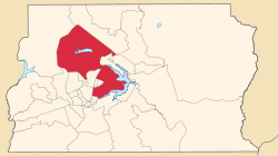
 Localization of Brasília in Federal District | |
| Country | |
| Region | Central-West |
| State | |
| Founded | April 21, 1960 |
| Area | |
| • Federal capital | 5,802 km2 (2240.164 sq mi) |
| Elevation | 1,172 m (3,845 ft) |
| Population (2010) | |
| • Federal capital | ୨୫,୬୨,୯୬୩ (୪th) |
| • Density | 441.565/km2 (1144/sq mi) |
| • Metro | ୩୭,୧୬,୯୯୬ (୬th) |
| Demonym | Brasiliense |
| GDP | |
| • Year | 2006 estimate |
| • Total | R$ 110,630,000,000 (8th) |
| • Per capita | R$ 45,600 (1st) |
| HDI | |
| • Year | 2005 |
| • Category | 0.911 – very high (1st) |
| Time zone | UTC−3 (BRT) |
| • Summer (DST) | UTC−2 (BRST) |
| Postal Code | 70000-000 |
| Area code | +55 61 |
| Website | www.brasilia.df.gov.br |
| Type | Cultural |
| Criteria | i, iv |
| Designated | 1987 (11th session) |
| Reference no. | 445 |
| State Party | Brazil |
| Region | Latin America and the Caribbean |
ବ୍ରାସିଲିଆ, ବ୍ରାଜିଲର ରାଜଧାନୀ।
ଭୂଗୋଳ
[ସମ୍ପାଦନା]ଇତିହାସ
[ସମ୍ପାଦନା]ପର୍ଯ୍ୟଟନ
[ସମ୍ପାଦନା]ଆଧାର
[ସମ୍ପାଦନା]ବାହାର ତଥ୍ୟ
[ସମ୍ପାଦନା]| Brasília ବାବଦରେ ଉଇକିମିଡ଼ିଆର ସହଯୋଗୀ ପ୍ରକଳ୍ପଗୁଡ଼ିକରୁ ଅଧିକ ଜାଣନ୍ତୁ: | |
| ଉଇକିଅଭିଧାନରେ ଶବ୍ଦାର୍ଥମାନ ଖୋଜନ୍ତୁ | |
| କମନ୍ସରେ ଛବି ଓ ମିଡ଼ିଆସବୁ ଖୋଜନ୍ତୁ | |
| ଉଇକିମହାବିହାରରେ ଶିକ୍ଷଣ ଆଧାରମାନ ଖୋଜନ୍ତୁ | |
| ଉଇକିସମ୍ବାଦରେ ସମ୍ବାଦ ଲେଖାମାନ ଖୋଜନ୍ତୁ | |
| ଉଇକିକଥାରୁ ଢଗଢମାଳି ଓ କଥାମାନ | |
| ଉଇକିଉତ୍ସରୁ ମୂଳାଧାର ଲେଖାମାନ | |
| ଉଇକିପୋଥିରେ ପଢ଼ାବହିମାନ | |
- Page of the Regional Administration of Brasília Archived 2014-06-25 at the Wayback Machine.
- Page of the Government of the Federal District Archived 2014-06-25 at the Wayback Machine.
- Download Free Brasília App Guide Archived 2014-05-28 at the Wayback Machine.
- Brasília's Official Guide Archived 2011-02-25 at the Wayback Machine.
- GigaPan Panoramic Photographs and Info About Brasilia Archived 2017-09-28 at the Wayback Machine.
- (Portuguese) Official Brasília site Archived 2014-06-25 at the Wayback Machine.
- (Portuguese) Photos 360° of Brasilia – GUIABSB
- (Portuguese) About Brasilia Archived 2014-07-14 at the Wayback Machine.
15°47′56″S 47°52′00″W / 15.79889°S 47.86667°W
| ଏହି ପ୍ରସଙ୍ଗଟି ଅସମ୍ପୂର୍ଣ୍ଣ ଅଟେ । ଆପଣ ଏହାକୁ ସଂପୂର୍ଣ୍ଣ କରି ଉଇକିପିଡ଼ିଆକୁ ସମୃଦ୍ଧ କରିପାରିବେ । |
