
ଫାଇଲ:Ogasawara islands.png
ଏହି ଦେଖଣାର ଆକାର: ୭୬୦ × ୬୦୦ ପିକ୍ସେଲ । ବାକି ରେଜୋଲୁସନ: ୩୦୪ × ୨୪୦ ପିକ୍ସେଲ | ୬୦୮ × ୪୮୦ ପିକ୍ସେଲ | ୧,୦୧୧ × ୭୯୮ ପିକ୍ସେଲ.
ମୂଳ ଫାଇଲ (୧,୦୧୧ × ୭୯୮ ପିକସେଲ, ଫାଇଲ ଆକାର: ୨୯୬ KB, ଏମ.ଆଇ.ଏମ.ଇର ପ୍ରକାର: image/png)
This is a file from the Wikimedia Commons. Information from its description page there is shown below. |
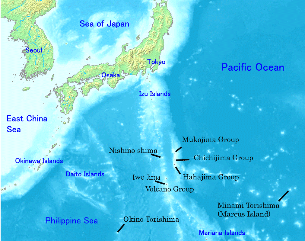
Map of Ogasawara Islands. Created by Map of ogasawara islands.png
This image is in the public domain because it came from the site https://www.demis.nl/products/web-map-server/examples/ and was released by the copyright holder. Permission is granted to copy, distribute and/or modify this map since it is based on free of copyright images from: www.demis.nl. See also approval email on de.wp and its clarification.
|
| This work has been released into the public domain by its copyright holder, www.demis.nl. This applies worldwide. କେତେକ ଦେଶରେ ଏହା ନ୍ୟାୟମତେ ଅନୁମୋଦିତ ହୋଇନପାରେ, ଯଦି ସେମିତି ହୁଏ: www.demis.nl ଯେ ପର୍ଯ୍ୟନ୍ତ ଆଇନରେ କିଛି ସର୍ତ୍ତ ଦରକାର ନ ପଡ଼େ ସେ ପର୍ଯ୍ୟନ୍ତ ସଭିଙ୍କୁ କୌଣସି ବି ଉଦ୍ଦେଶ୍ୟରେ ଏହ କାମଟିକୁ ନିସର୍ତ୍ତ ବ୍ୟବହାର କରିବାକୁ ଅନୁମତି ଦେଉଛନ୍ତି ।
|
ଫାଇଲ ଇତିହାସ
ଏହା ଫାଇଲଟି ସେତେବେଳେ ଯେମିତି ଦିଶୁଥିଲା ତାହା ଦେଖିବା ପାଇଁ ତାରିଖ/ବେଳା ଉପରେ କ୍ଲିକ କରନ୍ତୁ
| ତାରିଖ/ବେଳ | ନଖ ଦେଖଣା | ଆକାର | ବ୍ୟବହାରକାରୀ | ମତାମତ | |
|---|---|---|---|---|---|
| ଏବେକାର | ୦୩:୩୧, ୧ ଜାନୁଆରୀ ୨୦୦୮ | | ୧,୦୧୧ × ୭୯୮ (୨୯୬ KB) | Sagredo | Created by [http://commons.wikimedia.org/wiki/Image:Map_of_ogasawara_islands.png Map of ogasawara islands.png] {{Information |Description=Map of Ogasawara Islands. |Source= |Date= |Author= |Permission={{demis-pd}} }} |
| ୧୦:୫୯, ୩୦ ଅପ୍ରେଲ ୨୦୦୬ |  | ୧,୦୧୧ × ୭୯୮ (୨୬୦ KB) | Tdk~commonswiki | Map of Ogasawara Islands. Created by [Image:Map of ogasawara islands.png] {{demis-pd}} |
ଫାଇଲ ବ୍ୟବହାର
ଏହି ସବୁପୃଷ୍ଠା ଏହି ଫାଇଲଟିକୁ ଯୋଡ଼ିଥାନ୍ତି:
ଜଗତ ଫାଇଲ ବ୍ୟବହାର
ତଳଲିଖିତ ଉଇକିସବୁ ଏହି ଫାଇଲଟିକୁ ବ୍ୟବହାର କରିଥାନ୍ତି:
- ar.wikipedia.orgରେ ବ୍ୟବହାର
- ast.wikipedia.orgରେ ବ୍ୟବହାର
- az.wikipedia.orgରେ ବ୍ୟବହାର
- ban.wikipedia.orgରେ ବ୍ୟବହାର
- ca.wikipedia.orgରେ ବ୍ୟବହାର
- cs.wikipedia.orgରେ ବ୍ୟବହାର
- cy.wikipedia.orgରେ ବ୍ୟବହାର
- en.wikipedia.orgରେ ବ୍ୟବହାର
- Geography of Japan
- Tokyo
- List of islands of Japan
- Bonin Islands
- Ogasawara, Tokyo
- Japanese archipelago
- Nanpō Islands
- Portal:Japan
- Bonin white-eye
- Wikipedia:Graphics Lab/Images to improve/Archive/Jan 2008
- Ogasawara Subprefecture
- Wandering Island
- List of governors of the Nanpō Islands
- Geography of the Bonin Islands
- eo.wikipedia.orgରେ ବ୍ୟବହାର
- es.wikipedia.orgରେ ବ୍ୟବହାର
- eu.wikipedia.orgରେ ବ୍ୟବହାର
- fa.wikipedia.orgରେ ବ୍ୟବହାର
- fi.wikipedia.orgରେ ବ୍ୟବହାର
- fr.wikipedia.orgରେ ବ୍ୟବହାର
- gl.wikipedia.orgରେ ବ୍ୟବହାର
- he.wikipedia.orgରେ ବ୍ୟବହାର
- hr.wikipedia.orgରେ ବ୍ୟବହାର
- hy.wikipedia.orgରେ ବ୍ୟବହାର
- id.wikipedia.orgରେ ବ୍ୟବହାର
- ilo.wikipedia.orgରେ ବ୍ୟବହାର
ଏହି ଫାଇଲଟିର ଅଧିକ ବିଶ୍ୱବ୍ୟାପୀ ବ୍ୟବହାର ଦେଖନ୍ତୁ ।