
ଫାଇଲ:Départements et régions de France.svg

Size of this PNG preview of this SVG file: ୫୮୮ × ୫୫୦ ପିକ୍ସେଲ. ବାକି ରେଜୋଲୁସନ: ୨୫୭ × ୨୪୦ ପିକ୍ସେଲ | ୫୧୩ × ୪୮୦ ପିକ୍ସେଲ | ୮୨୧ × ୭୬୮ ପିକ୍ସେଲ | ୧,୦୯୫ × ୧,୦୨୪ ପିକ୍ସେଲ | ୨,୧୯୦ × ୨,୦୪୮ ପିକ୍ସେଲ.
ମୂଳ ଫାଇଲ (SVG ଫାଇଲ, ସାଧାରଣ ମାପ ୫୮୮ × ୫୫୦ ପିକ୍ସେଲ, ଫାଇଲ ଆକାର: ୩୬୨ KB)
This is a file from the Wikimedia Commons. Information from its description page there is shown below. |
ସାରକଥା
| ବିବରଣୀ |
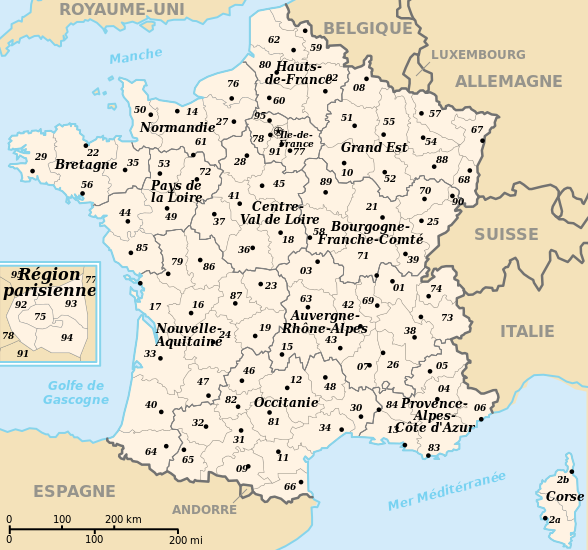
 English: Departements and region of France. French geographics objects use ISO 3166-2:FR for ids.
Español: Mapa de los departamentos franceses.
Français : Départements et régions de France avec leurs préfectures. Les objects géographiques français utilisent les identifiants provenant de ISO 3166-2:FR |
||
| ତାରିଖ | |||
| ମୂଳାଧାର | ଆପଣା କାମ | ||
| ଲେଖକ | bayo | ||
| ଅନୁମତି (ଏହି ଫାଇଲକୁ ପୁଣି ବ୍ୟବହାର କରିବେ) |
|
||
| ଅନ୍ୟ ସଂସ୍କରଣ |
[]
|
![(français) Départements (numérotés) et régions de France avant 01/01/2016 (nommées, non colorisés) [source of all the following derivatives]](http://commons.wikimedia.org/wiki/File:D%C3%A9partements_et_r%C3%A9gions_de_France.svg)


![(français) Départements (numérotés) et régions de France avant 01/01/2016 (non nommées, non colorisées) [rendu amélioré] (version utilisée pour rendre la carte clicable par département)](http://commons.wikimedia.org/wiki/File:D%C3%A9partements_et_r%C3%A9gions_de_France_-_Noname-2016.svg)


![(français) Départements (numérotés) et régions de France avant 01/01/2016 (nommées et colorisées) [regions named/colored]](http://commons.wikimedia.org/wiki/File:D%C3%A9partements%2Br%C3%A9gions_(France).svg)
![(français) Départements (numérotés) et régions de France avant 01/01/2016 (nommées et colorisées) [15% magnified, rapid JPEG format 5x faster]](http://commons.wikimedia.org/wiki/File:France_departements_regions_narrow.jpg)
![(français) Départements de France (numérotés, non colorisés)[numeric labels, uncolorized]](http://commons.wikimedia.org/wiki/File:D%C3%A9partements_de_France.svg)


![(multilingue) Départements de France (sans aucun libellé) [No labels]](http://commons.wikimedia.org/wiki/File:D%C3%A9partements_et_r%C3%A9gions_de_France_vide.svg)
ଫାଇଲ ଇତିହାସ
ଏହା ଫାଇଲଟି ସେତେବେଳେ ଯେମିତି ଦିଶୁଥିଲା ତାହା ଦେଖିବା ପାଇଁ ତାରିଖ/ବେଳା ଉପରେ କ୍ଲିକ କରନ୍ତୁ
| ତାରିଖ/ବେଳ | ନଖ ଦେଖଣା | ଆକାର | ବ୍ୟବହାରକାରୀ | ମତାମତ | |
|---|---|---|---|---|---|
| ଏବେକାର | ୧୭:୨୦, ୨୬ ଅପ୍ରେଲ ୨୦୨୪ | | ୫୮୮ × ୫୫୦ (୩୬୨ KB) | Jack ma | - correction of region limits (closing of Grand Est and Nouvelle-Aquitaine) |
| ୧୪:୩୨, ୧୨ ଅପ୍ରେଲ ୨୦୨୪ |  | ୫୮୮ × ୫୫୦ (୪୩୮ KB) | Jack ma | Updated French administrative regions of 2016 | |
| ୨୧:୪୮, ୨୨ ଜୁଲାଇ ୨୦୧୪ |  | ୫୮୮ × ୫୫୦ (୪୬୬ KB) | Seudo | Fixed orthograph mistake ("région parisenne") and added hyphens in Pays-de-la-Loire | |
| ୦୮:୨୫, ୧୬ ମଇ ୨୦୦୯ |  | ୫୮୮ × ୫୫୦ (୪୬୬ KB) | Archimatth | Une seule préfecture varoise | |
| ୧୨:୫୬, ୨୦ ଜୁନ ୨୦୦୮ |  | ୫୮୮ × ୫୫୦ (୪୬୭ KB) | Bayo | patch region/departement id with ISO 3166-2:FR | |
| ୧୪:୩୨, ୧୭ ଜୁନ ୨୦୦୮ |  | ୫୮୮ × ୫୫୦ (୪୭୪ KB) | Bayo | {{Information |Description= |Source= |Date= |Author= |Permission= |other_versions= }} | |
| ୨୨:୨୬, ୧୦ ମଇ ୨୦୦୮ |  | ୫୮୮ × ୫୫୦ (୪୫୯ KB) | Bayo | region name bigger, patch typo of some names | |
| ୦୨:୦୪, ୨୩ ମଇ ୨୦୦୬ |  | ୫୮୮ × ୫୫୦ (୪୫୯ KB) | Bayo | patch : typo | |
| ୨୦:୪୧, ୧୭ ଅପ୍ରେଲ ୨୦୦୬ |  | ୫୮୮ × ୫୫୦ (୪୫୯ KB) | Bayo | ajout de l'échelle | |
| ୨୦:୧୫, ୧୭ ଅପ୍ରେଲ ୨୦୦୬ |  | ୫୮୮ × ୫୫୦ (୪୫୫ KB) | Bayo | *'''description''' : Départements et régions et de France avec leurs préfectures. *'''auteur''' : bayo Category:Maps of departements of France Category:Maps of régions of France == Licensing == {{PD-self}} |
ଫାଇଲ ବ୍ୟବହାର
ଏହି ଫାଇଲ ସହିତ ଯୋଡ଼ା ଗୋଟିଏ ବି ପୃଷ୍ଠା ନାହିଁ ।
ଜଗତ ଫାଇଲ ବ୍ୟବହାର
ତଳଲିଖିତ ଉଇକିସବୁ ଏହି ଫାଇଲଟିକୁ ବ୍ୟବହାର କରିଥାନ୍ତି:
- af.wikipedia.orgରେ ବ୍ୟବହାର
- ceb.wikipedia.orgରେ ବ୍ୟବହାର
- da.wikipedia.orgରେ ବ୍ୟବହାର
- es.wikipedia.orgରେ ବ୍ୟବହାର
- eu.wikipedia.orgରେ ବ୍ୟବହାର
- fi.wikipedia.orgରେ ବ୍ୟବହାର
- fr.wikipedia.orgରେ ବ୍ୟବହାର
- Aménagement du territoire en France
- Discussion modèle:Fragéoloc
- Wikipédia:Atelier graphique/Images à améliorer/Archives/Novembre 2006
- Wikipédia:Atelier graphique/Images à améliorer/Archives/Mai 2007
- Discussion utilisateur:Mirondia
- Utilisateur:Wikisoft*/Tests cartes
- Discussion utilisateur:Sting/Archive 08
- Patrimoine juif d'Alsace
- Patrimoine juif de Lorraine
- Patrimoine juif du Sud-Est de la France et de la principauté de Monaco
- Patrimoine juif d'Île-de-France
- Patrimoine juif du Sud-Ouest de la France
- Patrimoine juif des régions du centre, partie ouest
- Patrimoine juif du Nord et de l'Est de la France (sauf Alsace et Lorraine)
- Patrimoine protestant de Lorraine
- ia.wikipedia.orgରେ ବ୍ୟବହାର
- la.wikipedia.orgରେ ବ୍ୟବହାର
- lt.wikipedia.orgରେ ବ୍ୟବହାର
- oc.wikipedia.orgରେ ବ୍ୟବହାର
- pt.wikipedia.orgରେ ବ୍ୟବହାର
- qu.wikipedia.orgରେ ବ୍ୟବହାର
- se.wikipedia.orgରେ ବ୍ୟବହାର
- vi.wikipedia.orgରେ ବ୍ୟବହାର