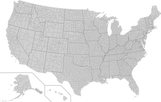
ଫାଇଲ:USA Counties.svg
ଦେଖଣା

Size of this PNG preview of this SVG file: ୫୫୫ × ୩୫୨ ପିକ୍ସେଲ. ବାକି ରେଜୋଲୁସନ: ୩୨୦ × ୨୦୩ ପିକ୍ସେଲ | ୬୪୦ × ୪୦୬ ପିକ୍ସେଲ | ୧,୦୨୪ × ୬୪୯ ପିକ୍ସେଲ | ୧,୨୮୦ × ୮୧୨ ପିକ୍ସେଲ | ୨,୫୬୦ × ୧,୬୨୪ ପିକ୍ସେଲ.
ମୂଳ ଫାଇଲ (SVG ଫାଇଲ, ସାଧାରଣ ମାପ ୫୫୫ × ୩୫୨ ପିକ୍ସେଲ, ଫାଇଲ ଆକାର: ୧.୧୧ MB)
ଫାଇଲ ଇତିହାସ
ଏହା ଫାଇଲଟି ସେତେବେଳେ ଯେମିତି ଦିଶୁଥିଲା ତାହା ଦେଖିବା ପାଇଁ ତାରିଖ/ବେଳା ଉପରେ କ୍ଲିକ କରନ୍ତୁ
| ତାରିଖ/ବେଳ | ନଖ ଦେଖଣା | ଆକାର | ବ୍ୟବହାରକାରୀ | ମତାମତ | |
|---|---|---|---|---|---|
| ଏବେକାର | ୧୦:୪୮, ୧୦ ଅଗଷ୍ଟ ୨୦୨୨ |  | ୫୫୫ × ୩୫୨ (୧.୧୧ MB) | DemonDays64 | Fixed some problems: merged southern part of Unorganized Alaska into one shape; properly labeled Somerset MD, which Accomack VA had been mislabeled as |
| ୧୧:୫୨, ୧୭ ସେପ୍ଟେମ୍ବର ୨୦୨୦ |  | ୫୫୫ × ୩୫୨ (୧.୧୧ MB) | DemonDays64 | Fixed misspelling of "Albemarle" as "Albermarle" | |
| ୨୧:୨୬, ୧୦ ସେପ୍ଟେମ୍ବର ୨୦୧୮ |  | ୫୫୫ × ୩୫୨ (୧.୧୧ MB) | JoKalliauer | restored id-names and css from 03:49, 26. Mär. 2016 | |
| ୧୨:୦୮, ୩୦ ଅଗଷ୍ଟ ୨୦୧୮ |  | ୫୫୫ × ୩୫୨ (୬୭୦ KB) | JoKalliauer | Smaller file-size. Cleaner code. valid file | |
| ୦୯:୧୯, ୨୬ ମାର୍ଚ୍ଚ ୨୦୧୬ |  | ୫୫୫ × ୩୫୨ (୧.୫୮ MB) | Spesh531 | updating borders, more accurate | |
| ୨୧:୧୭, ୨୩ ଡିସେମ୍ବର ୨୦୦୭ |  | ୫୫୫ × ୩୫୨ (୨.୦୩ MB) | Lokal Profil | Fixed state borders and fixed the two parts of Fulton County (Kentucky) | |
| ୦୭:୫୦, ୧୦ ଡିସେମ୍ବର ୨୦୦୭ |  | ୫୫୫ × ୩୫୨ (୨.୦୪ MB) | Lokal Profil | Graphical and code cleanup | |
| ୦୬:୪୫, ୧୦ ଡିସେମ୍ବର ୨୦୦୭ |  | ୭୯୨ × ୬୧୨ (୨.୦୪ MB) | Lokal Profil | First stab at a code cleanup | |
| ୦୫:୪୪, ୨୯ ଅଗଷ୍ଟ ୨୦୦୬ |  | ୭୯୨ × ୬୧୨ (୨.୭୧ MB) | Petr Dlouhý | Original file: en:Image:USA CountiesSVG.zip This ZIP file contains an SVG map of the United States showing the borders of states and counties in high detail. It was derived from [http://www2.census.gov/geo/maps/special |
ଫାଇଲ ବ୍ୟବହାର
ଏହି ଫାଇଲ ସହିତ ଯୋଡ଼ା ଗୋଟିଏ ବି ପୃଷ୍ଠା ନାହିଁ ।
ଜଗତ ଫାଇଲ ବ୍ୟବହାର
ତଳଲିଖିତ ଉଇକିସବୁ ଏହି ଫାଇଲଟିକୁ ବ୍ୟବହାର କରିଥାନ୍ତି:
- af.wikipedia.orgରେ ବ୍ୟବହାର
- en.wikipedia.orgରେ ବ୍ୟବହାର
- fa.wikipedia.orgରେ ବ୍ୟବହାର
- fi.wikipedia.orgରେ ବ୍ୟବହାର
- he.wikipedia.orgରେ ବ୍ୟବହାର
- hi.wikipedia.orgରେ ବ୍ୟବହାର
- hu.wikipedia.orgରେ ବ୍ୟବହାର
- io.wikipedia.orgରେ ବ୍ୟବହାର
- pnb.wikipedia.orgରେ ବ୍ୟବହାର
- pt.wikipedia.orgରେ ବ୍ୟବହାର
- ro.wikipedia.orgରେ ବ୍ୟବହାର
- sh.wikipedia.orgରେ ବ୍ୟବହାର
- sq.wikipedia.orgରେ ବ୍ୟବହାର
- sr.wikipedia.orgରେ ବ୍ୟବହାର
- tr.wikipedia.orgରେ ବ୍ୟବହାର
- ur.wikipedia.orgରେ ବ୍ୟବହାର


