
ଫାଇଲ:Krim 2014 de.svg

Size of this PNG preview of this SVG file: ୬୬୫ × ୪୪୧ ପିକ୍ସେଲ. ବାକି ରେଜୋଲୁସନ: ୩୨୦ × ୨୧୨ ପିକ୍ସେଲ | ୬୪୦ × ୪୨୪ ପିକ୍ସେଲ | ୧,୦୨୪ × ୬୭୯ ପିକ୍ସେଲ | ୧,୨୮୦ × ୮୪୯ ପିକ୍ସେଲ | ୨,୫୬୦ × ୧,୬୯୮ ପିକ୍ସେଲ.
ମୂଳ ଫାଇଲ (SVG ଫାଇଲ, ସାଧାରଣ ମାପ ୬୬୫ × ୪୪୧ ପିକ୍ସେଲ, ଫାଇଲ ଆକାର: ୧୦୩ KB)
This is a file from the Wikimedia Commons. Information from its description page there is shown below. |
ସାରକଥା
| ବିବରଣୀ |
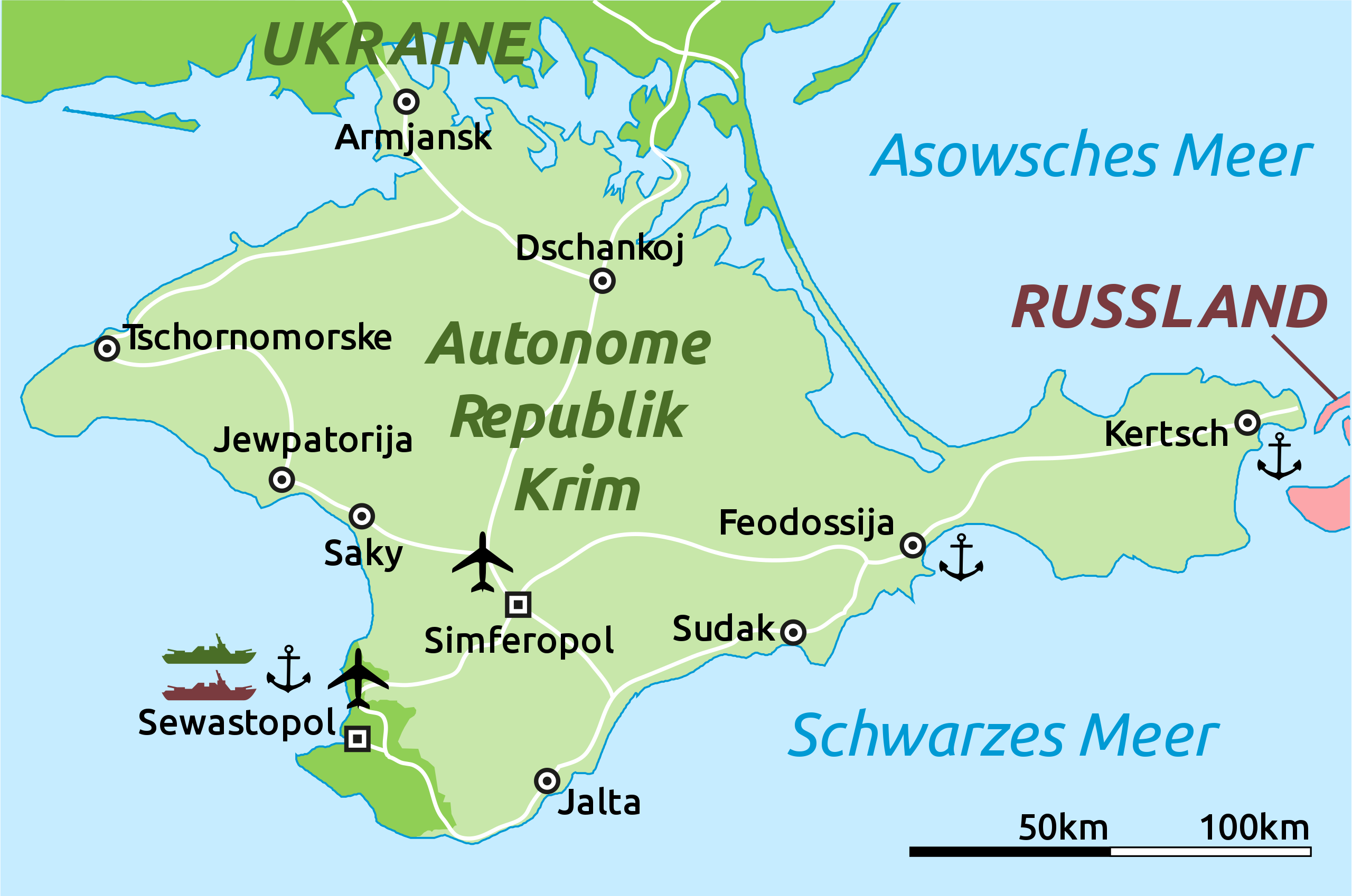
Deutsch: Karte der Krim-Republik.
English: Map of the Autonomous Republic of Crimea and of Sevastopol, Ukraine. |
| ତାରିଖ | |
| ମୂଳାଧାର |
This file was derived from : |
| ଲେଖକ |
Original: Vector: |
| ଅନ୍ୟ ସଂସ୍କରଣ |
|
| SVG genesis | This locator map was created with Adobe Illustrator. |

ସତ୍ଵ
ମୁଁ, ଏହି କାମର ସତ୍ଵାଧିକାରୀ, ଏଠାରେ ତଳଲିଖିତ ଲାଇସେନ୍ସ ଅଧୀନରେ ଏହାକୁ ପ୍ରକାଶ କଲି:
| ଏହି ଫାଇଲଟି କ୍ରିଏଟିଭ କମନ୍ସ CC0 1.0 ସାର୍ବଜନୀନ ପବ୍ଲିକ ଡୋମେନରେ ମିଳୁଅଛି । | |
| ଏହି କାମ ସହ ସମ୍ବନ୍ଧିତ ବ୍ୟକ୍ତି ଏହାକୁ ପବ୍ଲିକ ଡୋମେନ ରେ ନିଜର ସତ୍ଵାଧିକାରକୁ ଛାଡ଼ କରି ଜଗତସାରାର ସତ୍ଵାଧିକାର ଅନୁସାରେ ଏହା ସହ ସମ୍ବନ୍ଧିତ ଓ ପାଖାପାଖି ଅଧିକାର, ନିୟମ କାନୁନ ଦେଇ ଅନୁମୋଦିତ ନିୟମ ଯାଏଁ ଦାନ କଲେ। କାହାର ଅନୁମତି ବିନା ଆପଣ ଏହି କାମର ନକଲ, ବଦଳ, ବଣ୍ଟନ କରିପାରିବେ ।
|
ମୂଲ ଅପଲୋଡ଼ ଫାଇଲ
This image is a derivative work of the following images:
- Crimea republic map.png licensed with Cc-zero
- 2012-09-06T09:53:36Z PANONIAN 1031x684 (62218 Bytes) corrected Sevastopol border
- 2012-08-30T11:55:15Z PANONIAN 1031x684 (61885 Bytes) {{Information |Description=Map of the Autonomous Republic Crimea, Ukraine. |Source={{own}} |Date=2012 |Author= [[User:PANONIAN|PANONIAN]] |Permission= |other_versions= }}
Uploaded with derivativeFX
ଫାଇଲ ଇତିହାସ
ଏହା ଫାଇଲଟି ସେତେବେଳେ ଯେମିତି ଦିଶୁଥିଲା ତାହା ଦେଖିବା ପାଇଁ ତାରିଖ/ବେଳା ଉପରେ କ୍ଲିକ କରନ୍ତୁ
| ତାରିଖ/ବେଳ | ନଖ ଦେଖଣା | ଆକାର | ବ୍ୟବହାରକାରୀ | ମତାମତ | |
|---|---|---|---|---|---|
| ଏବେକାର | ୨୨:୨୨, ୫ ମାର୍ଚ୍ଚ ୨୦୧୪ | | ୬୬୫ × ୪୪୧ (୧୦୩ KB) | Schwarzorange | moved "Saky" closer to Saky |
| ୦୦:୪୦, ୫ ମାର୍ଚ୍ଚ ୨୦୧୪ |  | ୬୬୫ × ୪୪୧ (୧୦୩ KB) | Martin Kraft | Maßstab, +Tschornomorske, diverse kleiner Optimierungen | |
| ୧୬:୦୭, ୪ ମାର୍ଚ୍ଚ ୨୦୧୪ |  | ୬୬୫ × ୪୪୧ (୧୦୩ KB) | Martin Kraft | Dzhankoi -> Dschankoj | |
| ୧୬:୫୫, ୩ ମାର୍ଚ୍ଚ ୨୦୧୪ |  | ୬୬୫ × ୪୪୧ (୧୦୩ KB) | Martin Kraft | Straßen, weiter Städte, Farben | |
| ୧୪:୦୯, ୩ ମାର୍ଚ୍ଚ ୨୦୧୪ |  | ୬୬୫ × ୪୪୧ (୧୦୫ KB) | Martin Kraft | Pfade aufgeräumt. Dateigröße halbiert. | |
| ୧୩:୧୨, ୩ ମାର୍ଚ୍ଚ ୨୦୧୪ |  | ୬୬୫ × ୪୪୧ (୨୨୯ KB) | Furfur | Sinferopol -> Simferopol | |
| ୦୪:୦୯, ୩ ମାର୍ଚ୍ଚ ୨୦୧୪ |  | ୬୬୫ × ୪୪୧ (୨୨୫ KB) | Martin Kraft | +Flughafen | |
| ୦୩:୫୭, ୩ ମାର୍ଚ୍ଚ ୨୦୧୪ |  | ୬୬୫ × ୪୪୧ (୨୨୬ KB) | Martin Kraft | Ohne Schraffur ist doch irgendwie besser | |
| ୦୩:୪୪, ୩ ମାର୍ଚ୍ଚ ୨୦୧୪ |  | ୬୬୫ × ୪୪୧ (୨୩୦ KB) | Martin Kraft | Karte komplett überarbeitet. Bei Nichtgefallen einfach revertieren, dann stelle ich sie seperat ein | |
| ୦୨:୧୪, ୩ ମାର୍ଚ୍ଚ ୨୦୧୪ |  | ୬୬୫ × ୪୪୧ (୩୧୩ KB) | Furfur | verbessert |
ଫାଇଲ ବ୍ୟବହାର
ଏହି ଫାଇଲ ସହିତ ଯୋଡ଼ା ଗୋଟିଏ ବି ପୃଷ୍ଠା ନାହିଁ ।
ଜଗତ ଫାଇଲ ବ୍ୟବହାର
ତଳଲିଖିତ ଉଇକିସବୁ ଏହି ଫାଇଲଟିକୁ ବ୍ୟବହାର କରିଥାନ୍ତି:
- de.wikipedia.orgରେ ବ୍ୟବହାର
- fr.wikipedia.orgରେ ବ୍ୟବହାର
- sr.wikinews.orgରେ ବ୍ୟବହାର