ଫାଇଲ:Geographic distribution of Bengali language.png

Page contents not supported in other languages.
ଉଇକିପିଡ଼ିଆ‌ରୁ

ମୂଳ ଫାଇଲ(୨,୮୦୬ × ୨,୦୮୦ ପିକସେଲ, ଫାଇଲ ଆକାର: ୧.୩୬ MB, ଏମ.ଆଇ.ଏମ.ଇର ପ୍ରକାର: image/png)

ସାରକଥା

ବିବରଣୀ
Ελληνικά: Γεωγραφική κατανομή της Βεγγαλικής Γλώσσας ανά επαρχία της Ινδίας και στο Μπανγκλαντές, τα χρώματα στις επαρχίες ποικίλουν ανάλογα με το ποσοστό ομιλητών (δεδομένα απογραφής 2011). Παράγωγο του αρχείου India district map (de-facto).svg.
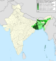
English: Geographic distribution of Bengali language in India and Bangladesh. The map covers each district of India and the five shades of green show the percentage of Bengali language speakers in each district. Source: Indian census 2011. Feel free to enrich the map with data for more Indian districts, or fix any mistakes. Derivative of the file India district map (de-facto).svg.
ତାରିଖ
ମୂଳାଧାର ଆପଣା କାମ
ଲେଖକ NikosLikomitros

ସତ୍ଵ

ମୁଁ, ଏହି କାମର ସତ୍ଵାଧିକାରୀ, ଏଠାରେ ତଳଲିଖିତ ଲାଇସେନ୍ସ ଅଧୀନରେ ଏହାକୁ ପ୍ରକାଶ କଲି:
w:en:Creative Commons
ଶ୍ରେୟ ସେଆର ଏଲାଇକ
This file is licensed under the Creative Commons Attribution-Share Alike 4.0 International license.
ଆପଣ ଆରାମରେ:
  • ବାଣ୍ଟିପାରିବେ – କାମଟିକୁ ନକଲ କରିପାରିବେ, ବାଣ୍ଟିପାରିବେ ଓ ପ୍ରସାରଣ କରିପାରିବେ
  • ମିଶାଇପାରିବେ – କାମଟି ଅଭିଯୋଜନ କରିପାରିବେ
ତଳଲିଖିତ ସର୍ତ୍ତାବଳୀ ଅଧୀନରେ:
  • ଶ୍ରେୟ – ଆପଣ ମନେ କରି ଏହି କାମର ଆବଶ୍ୟକୀୟ ଶ୍ରେୟ ମୂଳ ଗଢ଼ାଳି ବା ସ୍ୱତ୍ୱାଧୀକାରୀଙ୍କୁ ଦେବେ ଏବଂ ଦେଲାବେଳେ ଲାଇସେନ୍ସର ଲିଙ୍କ ଦେଇ କି କି ବଦଳ କଲେ ଉଲ୍ଲେଖ କରିବେ । ଏହା ଉପଯୁକ୍ତ ଢଙ୍ଗରେ କରିବେ କିନ୍ତୁ ଲାଇସେନ୍ସ ଦେଉଥିବା ବ୍ୟକ୍ତି ଆପଣଙ୍କ ପ୍ରଚାର କଲା ଭଳି କିଛି ଲେଖିବେ ନାହିଁ ।
  • ସେଆର ଏଲାଇକ – ଯଦି ଆପଣ ଏହି କାମଟିକୁ ବଦଳାଇବେ, ରୂପାନ୍ତରଣ କରିବେ ବା ଏହାକୁ ନେଇ କିଛି ଗଢ଼ିବେ ତେବେ ଆପଣ ଏହାକୁ ଏକା ବା ଅଲଗା ଲାଇସେନ୍ସ ଭିତରେ ରଖିପାରିବେ ।

Captions

Add a one-line explanation of what this file represents
Geographic distribution of Bengali language in India and Bangladesh. The map covers each district of India and the five shades of green show the percentage of Bengali language speakers in each district. Source: Indian census 2011.

Items portrayed in this file

ଦର୍ଶାଏ

creator ଇଂରାଜୀ

some value

author name string ଇଂରାଜୀ: NikosLikomitros
Wikimedia username ଇଂରାଜୀ: NikosLikomitros

copyright status ଇଂରାଜୀ

copyrighted ଇଂରାଜୀ

media type ଇଂରାଜୀ

image/png

source of file ଇଂରାଜୀ

original creation by uploader ଇଂରାଜୀ

ଫାଇଲ ଇତିହାସ

ଏହା ଫାଇଲଟି ସେତେବେଳେ ଯେମିତି ଦିଶୁଥିଲା ତାହା ଦେଖିବା ପାଇଁ ତାରିଖ/ବେଳା ଉପରେ କ୍ଲିକ କରନ୍ତୁ

ତାରିଖ/ବେଳନଖ ଦେଖଣାଆକାରବ୍ୟବହାରକାରୀମତାମତ
ଏବେକାର୨୦:୩୫, ୨ ଜୁଲାଇ ୨୦୨୨୨୦:୩୫, ୨ ଜୁଲାଇ ୨୦୨୨ ପରିକା ସଙ୍କଳନର ନଖଦେଖଣା୨,୮୦୬ × ୨,୦୮୦ (୧.୩୬ MB)NikosLikomitrosA few districts of Arunachal Pradesh have a notable Bengali presence above of 1%, probably part of the Indian efforts to increase its presence in the region.
୨୨:୨୫, ୧ ଜୁଲାଇ ୨୦୨୨୨୨:୨୫, ୧ ଜୁଲାଇ ୨୦୨୨ ପରିକା ସଙ୍କଳନର ନଖଦେଖଣା୨,୮୦୬ × ୨,୦୮୦ (୧.୩୬ MB)NikosLikomitrosTwo extra fixes.
୨୨:୨୩, ୧ ଜୁଲାଇ ୨୦୨୨୨୨:୨୩, ୧ ଜୁଲାଇ ୨୦୨୨ ପରିକା ସଙ୍କଳନର ନଖଦେଖଣା୨,୮୦୬ × ୨,୦୮୦ (୧.୩୬ MB)NikosLikomitrosMinor fixes.
୨୨:୧୪, ୧ ଜୁଲାଇ ୨୦୨୨୨୨:୧୪, ୧ ଜୁଲାଇ ୨୦୨୨ ପରିକା ସଙ୍କଳନର ନଖଦେଖଣା୨,୮୦୬ × ୨,୦୮୦ (୧.୩୬ MB)NikosLikomitrosNow, this map covers all districts of India. Includes also extra information and a new colour key. The basemap is from Distribution_of_Jats_in_South_Asia.png.
୦୨:୩୯, ୨୭ ଜୁନ ୨୦୨୨୦୨:୩୯, ୨୭ ଜୁନ ୨୦୨୨ ପରିକା ସଙ୍କଳନର ନଖଦେଖଣା୧,୯୦୨ × ୨,୦୪୮ (୧,୦୦୨ KB)NikosLikomitrosUploaded own work with UploadWizard

ଏହି ଫାଇଲ ସହିତ ଯୋଡ଼ା ଗୋଟିଏ ବି ପୃଷ୍ଠା ନାହିଁ ।

ଜଗତ ଫାଇଲ ବ୍ୟବହାର

ତଳଲିଖିତ ଉଇକିସବୁ ଏହି ଫାଇଲଟିକୁ ବ୍ୟବହାର କରିଥାନ୍ତି:

ମେଟାଡାଟା