
ଫାଇଲ:St Matthew's Church, Rastrick - geograph.org.uk - 77228.jpg
ବଡ଼ ରେଜୋଲୁସନ ନାହିଁ ।
St_Matthew's_Church,_Rastrick_-_geograph.org.uk_-_77228.jpg (୬୪୦ × ୪୮୦ ପିକସେଲ, ଫାଇଲ ଆକାର: ୧୫୧ KB, ଏମ.ଆଇ.ଏମ.ଇର ପ୍ରକାର: image/jpeg)
This is a file from the Wikimedia Commons. Information from its description page there is shown below. |
ସାରକଥା
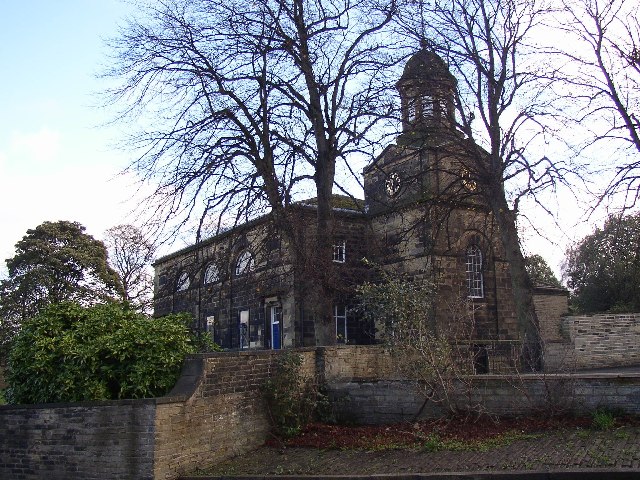
This is a photo of listed building number 1183810. |
| ବିବରଣୀ |
English: St Matthew's Church, Rastrick. St Matthew's Church was completed in 1798 and has a low west tower with a circular cupola over an octagonal belfry. The side towards the street has five bays with entrances in the first and last. Between these entrances are small rectangular windows set in arched surrounds in which are semi-circular windows with 'spider's web' glazing bars. Inside are three galleries on Tuscan columns. |
| ତାରିଖ | |
| ମୂଳାଧାର | From geograph.org.uk |
| ଲେଖକ | Humphrey Bolton |
| ଶ୍ରେୟ (required by the license) | Humphrey Bolton / St Matthew's Church, Rastrick / |
| Object location | | View this and other nearby images on: OpenStreetMap |
|---|
_&language=or)
ସତ୍ଵ

|
This image was taken from the Geograph project collection. See this photograph's page on the Geograph website for the photographer's contact details. The copyright on this image is owned by Humphrey Bolton and is licensed for reuse under the Creative Commons Attribution-ShareAlike 2.0 license.
|
ଏହି ଫାଇଲଟି କ୍ରିଏଟିଭ କମନ୍ସ ଅଧୀନରେ ଆଟ୍ରିବୁସନ ସେଆର-ଏଲାଇକ ୨.୦ ଜେନେରିକ ଲାଇସେନ୍ସରେ ପଞ୍ଜିକରଣ କରାଯାଇଅଛି ।
ଶ୍ରେୟ: Humphrey Bolton
- ଆପଣ ଆରାମରେ:
- ବାଣ୍ଟିପାରିବେ – କାମଟିକୁ ନକଲ କରିପାରିବେ, ବାଣ୍ଟିପାରିବେ ଓ ପ୍ରସାରଣ କରିପାରିବେ
- ମିଶାଇପାରିବେ – କାମଟି ଅଭିଯୋଜନ କରିପାରିବେ
- ତଳଲିଖିତ ସର୍ତ୍ତାବଳୀ ଅଧୀନରେ:
- ଶ୍ରେୟ – ଆପଣ ମନେ କରି ଏହି କାମର ଆବଶ୍ୟକୀୟ ଶ୍ରେୟ ମୂଳ ଗଢ଼ାଳି ବା ସ୍ୱତ୍ୱାଧୀକାରୀଙ୍କୁ ଦେବେ ଏବଂ ଦେଲାବେଳେ ଲାଇସେନ୍ସର ଲିଙ୍କ ଦେଇ କି କି ବଦଳ କଲେ ଉଲ୍ଲେଖ କରିବେ । ଏହା ଉପଯୁକ୍ତ ଢଙ୍ଗରେ କରିବେ କିନ୍ତୁ ଲାଇସେନ୍ସ ଦେଉଥିବା ବ୍ୟକ୍ତି ଆପଣଙ୍କ ପ୍ରଚାର କଲା ଭଳି କିଛି ଲେଖିବେ ନାହିଁ ।
- ସେଆର ଏଲାଇକ – ଯଦି ଆପଣ ଏହି କାମଟିକୁ ବଦଳାଇବେ, ରୂପାନ୍ତରଣ କରିବେ ବା ଏହାକୁ ନେଇ କିଛି ଗଢ଼ିବେ ତେବେ ଆପଣ ଏହାକୁ ଏକା ବା ଅଲଗା ଲାଇସେନ୍ସ ଭିତରେ ରଖିପାରିବେ ।
ଫାଇଲ ଇତିହାସ
ଏହା ଫାଇଲଟି ସେତେବେଳେ ଯେମିତି ଦିଶୁଥିଲା ତାହା ଦେଖିବା ପାଇଁ ତାରିଖ/ବେଳା ଉପରେ କ୍ଲିକ କରନ୍ତୁ
| ତାରିଖ/ବେଳ | ନଖ ଦେଖଣା | ଆକାର | ବ୍ୟବହାରକାରୀ | ମତାମତ | |
|---|---|---|---|---|---|
| ଏବେକାର | ୦୦:୫୬, ୩୧ ଜାନୁଆରୀ ୨୦୧୦ | | ୬୪୦ × ୪୮୦ (୧୫୧ KB) | GeographBot | == {{int:filedesc}} == {{Information |description={{en|1=St Matthew's Church, Rastrick. St Matthew's Church was completed in 1798 and has a low west tower with a circular cupola over an octagonal belfry. The side towards the street has five bays with ent |
ଫାଇଲ ବ୍ୟବହାର
ଏହି ଫାଇଲ ସହିତ ଯୋଡ଼ା ଗୋଟିଏ ବି ପୃଷ୍ଠା ନାହିଁ ।
ଜଗତ ଫାଇଲ ବ୍ୟବହାର
ତଳଲିଖିତ ଉଇକିସବୁ ଏହି ଫାଇଲଟିକୁ ବ୍ୟବହାର କରିଥାନ୍ତି:
- ang.wikipedia.orgରେ ବ୍ୟବହାର
- en.wikipedia.orgରେ ବ୍ୟବହାର
- pl.wikipedia.orgରେ ବ୍ୟବହାର
- www.wikidata.orgରେ ବ୍ୟବହାର