
ଫାଇଲ:Russian Empire Empire of Japan Locator.png

ଏହି ଦେଖଣାର ଆକାର: ୮୦୦ × ୩୭୦ ପିକ୍ସେଲ । ବାକି ରେଜୋଲୁସନ: ୩୨୦ × ୧୪୮ ପିକ୍ସେଲ | ୬୪୦ × ୨୯୬ ପିକ୍ସେଲ | ୧,୩୫୭ × ୬୨୮ ପିକ୍ସେଲ.
ମୂଳ ଫାଇଲ (୧,୩୫୭ × ୬୨୮ ପିକସେଲ, ଫାଇଲ ଆକାର: ୪୪ KB, ଏମ.ଆଇ.ଏମ.ଇର ପ୍ରକାର: image/png)
This is a file from the Wikimedia Commons. Information from its description page there is shown below. |
ସାରକଥା
| ବିବରଣୀ |
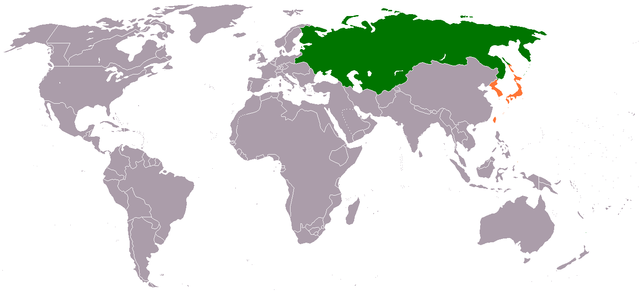
English: Locator map showing Japanese Empire and Russian Empire, from the annexation of Korea by Japan in August 1910 to the February Revolution in 1917.
日本語: 1910年8月の日韓併合から1917年の2月革命までの大日本帝国とロシア帝国の領土を示す地図。 |
| ତାରିଖ | ୧୫ ଜୁନ ୨୦୧୧ (original upload date) |
| ମୂଳାଧାର |
ଆପଣା କାମ Transferred from en.wikipedia |
| ଲେଖକ | Phoenix500 at en.wikipedia |
ସତ୍ଵ
Phoenix500 at en.wikipedia, ଏହି କାମର ସତ୍ଵାଧିକାରୀ, ଏଠାରେ ତଳଲିଖିତ ଲାଇସେନ୍ସ ଅଧୀନରେ ଏହାକୁ ପ୍ରକାଶ କଲେ:
| ଏହି ଫାଇଲଟି କ୍ରିଏଟିଭ କମନ୍ସ CC0 1.0 ସାର୍ବଜନୀନ ପବ୍ଲିକ ଡୋମେନରେ ମିଳୁଅଛି । | |
| ଏହି କାମ ସହ ସମ୍ବନ୍ଧିତ ବ୍ୟକ୍ତି ଏହାକୁ ପବ୍ଲିକ ଡୋମେନ ରେ ନିଜର ସତ୍ଵାଧିକାରକୁ ଛାଡ଼ କରି ଜଗତସାରାର ସତ୍ଵାଧିକାର ଅନୁସାରେ ଏହା ସହ ସମ୍ବନ୍ଧିତ ଓ ପାଖାପାଖି ଅଧିକାର, ନିୟମ କାନୁନ ଦେଇ ଅନୁମୋଦିତ ନିୟମ ଯାଏଁ ଦାନ କଲେ। କାହାର ଅନୁମତି ବିନା ଆପଣ ଏହି କାମର ନକଲ, ବଦଳ, ବଣ୍ଟନ କରିପାରିବେ ।
|
ମୂଲ ଅପଲୋଡ଼ ଫାଇଲ
The original description page was here. All following user names refer to en.wikipedia.
- 2011-06-15 05:13 Phoenix500 1357×628 (44715 bytes)
ଫାଇଲ ଇତିହାସ
ଏହା ଫାଇଲଟି ସେତେବେଳେ ଯେମିତି ଦିଶୁଥିଲା ତାହା ଦେଖିବା ପାଇଁ ତାରିଖ/ବେଳା ଉପରେ କ୍ଲିକ କରନ୍ତୁ
| ତାରିଖ/ବେଳ | ନଖ ଦେଖଣା | ଆକାର | ବ୍ୟବହାରକାରୀ | ମତାମତ | |
|---|---|---|---|---|---|
| ଏବେକାର | ୧୯:୫୦, ୨୯ ଜାନୁଆରୀ ୨୦୧୨ | | ୧,୩୫୭ × ୬୨୮ (୪୪ KB) | BotMultichillT | {{BotMoveToCommons|en.wikipedia|year={{subst:CURRENTYEAR}}|month={{subst:CURRENTMONTHNAME}}|day={{subst:CURRENTDAY}}}} == {{int:filedesc}} == {{Information |description={{en|1=}} |date={{Date|2011|6|15}} (original upload date) |source={{Own}}<BR />Transf |
ଫାଇଲ ବ୍ୟବହାର
ଏହି ଫାଇଲ ସହିତ ଯୋଡ଼ା ଗୋଟିଏ ବି ପୃଷ୍ଠା ନାହିଁ ।
ଜଗତ ଫାଇଲ ବ୍ୟବହାର
ତଳଲିଖିତ ଉଇକିସବୁ ଏହି ଫାଇଲଟିକୁ ବ୍ୟବହାର କରିଥାନ୍ତି:
- ar.wikipedia.orgରେ ବ୍ୟବହାର
- en.wikipedia.orgରେ ବ୍ୟବହାର
- www.wikidata.orgରେ ବ୍ୟବହାର