Jump to content

ଫାଇଲ:Pelagie Islands map.png

Page contents not supported in other languages.
ଉଇକିପିଡ଼ିଆ‌ରୁ

ମୂଳ ଫାଇଲ (୫୯୬ × ୭୦୫ ପିକସେଲ, ଫାଇଲ ଆକାର: ୯୧ KB, ଏମ.ଆଇ.ଏମ.ଇର ପ୍ରକାର: image/png)

This locator map image could be re-created using vector graphics as an SVG file. This has several advantages; see Commons:Media for cleanup for more information. If an SVG form of this image is available, please upload it and afterwards replace this template with {{vector version available|new image name}}.


It is recommended to name the SVG file “Pelagie Islands map.svg”—then the template Vector version available (or Vva) does not need the new image name parameter.

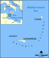
A map showing the location of the Pelagie Islands, including the islands Lampedusa, Linosa, and Lampione, in the Mediterranean Sea.

Blank version available at Image:Pelagie Islands blank map.png.

Created by NormanEinstein, May 25, 2005.

ମୁଁ, ଏହି କାମର ସତ୍ୱାଧିକାରୀ, ଏଠାରେ ତଳଲିଖିତ ଲାଇସେନ୍ସ ଅଧୀନରେ ଏହାକୁ ପ୍ରକାଶ କଲି:
GNU head ମାଗଣା ସଫ୍ଟବେର ଫାଉଣ୍ଡେସନ ଦେଇ ପ୍ରକାଶିତ କୌଣସି ବଦଳାଇ ନହେବା ଭଳି ଧାରା, ଆଗ ବା ପଛ ପଟ ମଲାଟ ବିନା GNU ଖୋଲା ଦଲିଲକାରଣ ଲାଇସେନ୍ସ ୧.୨ ତମ ସଙ୍କଳନ ବା ଆଉ କୌଣସି ସର୍ତ୍ତାବଳି ଅନୁସାରେ ଏହି ଦଲିଲର ନକଲ, ବଣ୍ଟନ ତଥା/କିମ୍ବା ବଦଳାଇବା ନିମନ୍ତେ ଅନୁମତି ଦିଆଗଲା । GNU ମାଗଣା ଦଲିଲକରଣ ଲାଇସେନ୍ସ ନାମକ ବିଭାଗରେ ଲାଇସେନ୍ସର ନକଲ ଦିଆଯାଇଅଛି ।
w:en:Creative Commons
ଶ୍ରେୟ ସେଆର ଏଲାଇକ
ଏହି ଫାଇଲଟି କ୍ରିଏଟିଭ କମନ୍ସ ଅଧୀନରେ ଆଟ୍ରିବୁସନ ସେଆର-ଏଲାଇକ ୩.୦ ଅନପୋର୍ଟେଡ଼ ଲାଇସେନ୍ସରେ ପଞ୍ଜିକରଣ କରାଯାଇଅଛି ।
ଆପଣ ଆରାମରେ:
  • ବାଣ୍ଟିପାରିବେ – କାମଟିକୁ ନକଲ କରିପାରିବେ, ବାଣ୍ଟିପାରିବେ ଓ ପ୍ରସାରଣ କରିପାରିବେ
  • ମିଶାଇପାରିବେ – କାମଟି ଅଭିଯୋଜନ କରିପାରିବେ
ତଳଲିଖିତ ସର୍ତ୍ତାବଳୀ ଅଧୀନରେ:
  • ଶ୍ରେୟ – ଆପଣ ମନେ କରି ଏହି କାମର ଆବଶ୍ୟକୀୟ ଶ୍ରେୟ ମୂଳ ଗଢ଼ାଳି ବା ସ୍ୱତ୍ୱାଧୀକାରୀଙ୍କୁ ଦେବେ ଏବଂ ଦେଲାବେଳେ ଲାଇସେନ୍ସର ଲିଙ୍କ ଦେଇ କି କି ବଦଳ କଲେ ଉଲ୍ଲେଖ କରିବେ । ଏହା ଉପଯୁକ୍ତ ଢଙ୍ଗରେ କରିବେ କିନ୍ତୁ ଲାଇସେନ୍ସ ଦେଉଥିବା ବ୍ୟକ୍ତି ଆପଣଙ୍କ ପ୍ରଚାର କଲା ଭଳି କିଛି ଲେଖିବେ ନାହିଁ ।
  • ସେଆର ଏଲାଇକ – ଯଦି ଆପଣ ଏହି କାମଟିକୁ ବଦଳାଇବେ, ରୂପାନ୍ତରଣ କରିବେ ବା ଏହାକୁ ନେଇ କିଛି ଗଢ଼ିବେ ତେବେ ଆପଣ ଏହାକୁ ଏକା ବା ଅଲଗା ଲାଇସେନ୍ସ ଭିତରେ ରଖିପାରିବେ ।
GFDL ଲାଇସେନ୍ସ ଅପଡେଟର ଏକ ଭାଗ ଭାବରେ ଏହି ଲାଇସେନ୍ସ ଚିହ୍ନଟି ଏହି ଫାଇଲରେ ଯୋଡ଼ା ଯାଇଥିଲା ।
ଆପଣ ନିଜ ପସନ୍ଦର ଲାଇସେନ୍ସ ବାଛିପାରିବେ ।

derivative works

Derivative works of this file:

Captions

Add a one-line explanation of what this file represents

Items portrayed in this file

ଦର୍ଶାଏ

copyright status ଇଂରାଜୀ

copyrighted ଇଂରାଜୀ

ଫାଇଲ ଇତିହାସ

ଏହା ଫାଇଲଟି ସେତେବେଳେ ଯେମିତି ଦିଶୁଥିଲା ତାହା ଦେଖିବା ପାଇଁ ତାରିଖ/ବେଳା ଉପରେ କ୍ଲିକ କରନ୍ତୁ

ତାରିଖ/ବେଳନଖ ଦେଖଣାଆକାରବ୍ୟବହାରକାରୀମତାମତ
ଏବେକାର୧୭:୩୬, ୩ ଜୁନ ୨୦୧୨୧୭:୩୬, ୩ ଜୁନ ୨୦୧୨ ପରିକା ସଙ୍କଳନର ନଖଦେଖଣା୫୯୬ × ୭୦୫ (୯୧ KB)Ras67cropped, opt.
୧୩:୨୬, ୨୩ ଡିସେମ୍ବର ୨୦୦୬୧୩:୨୬, ୨୩ ଡିସେମ୍ବର ୨୦୦୬ ପରିକା ସଙ୍କଳନର ନଖଦେଖଣା୬୦୦ × ୭୦୯ (୧୧୪ KB)Hoshieadded Montenegro. under same license as original.
୦୦:୪୩, ୨୬ ମଇ ୨୦୦୫୦୦:୪୩, ୨୬ ମଇ ୨୦୦୫ ପରିକା ସଙ୍କଳନର ନଖଦେଖଣା୬୦୦ × ୭୦୯ (୧୩୫ KB)NormanEinsteinA map showing the location of the Pelagie Islands, including the islands Lampedusa, Linosa, and Lampione, in the Mediterranean Sea. Created by NormanEinstein, May 25, 2005. {{GFDL-self}} Category:Maps of Italy

ଏହି ଫାଇଲ ସହିତ ଯୋଡ଼ା ଗୋଟିଏ ବି ପୃଷ୍ଠା ନାହିଁ ।

ଜଗତ ଫାଇଲ ବ୍ୟବହାର

ତଳଲିଖିତ ଉଇକିସବୁ ଏହି ଫାଇଲଟିକୁ ବ୍ୟବହାର କରିଥାନ୍ତି:

ଏହି ଫାଇଲଟିର ଅଧିକ ବିଶ୍ୱବ୍ୟାପୀ ବ୍ୟବହାର ଦେଖନ୍ତୁ ।

ମେଟାଡାଟା