
ଫାଇଲ:Oceania satellite map.jpg

ଏହି ଦେଖଣାର ଆକାର: ୬୦୦ × ୬୦୦ ପିକ୍ସେଲ । ବାକି ରେଜୋଲୁସନ: ୨୪୦ × ୨୪୦ ପିକ୍ସେଲ | ୪୮୦ × ୪୮୦ ପିକ୍ସେଲ | ୯୦୦ × ୯୦୦ ପିକ୍ସେଲ.
ମୂଳ ଫାଇଲ (୯୦୦ × ୯୦୦ ପିକସେଲ, ଫାଇଲ ଆକାର: ୪୫୧ KB, ଏମ.ଆଇ.ଏମ.ଇର ପ୍ରକାର: image/jpeg)
This is a file from the Wikimedia Commons. Information from its description page there is shown below. |
ସାରକଥା
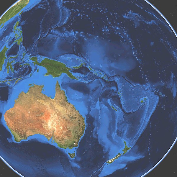
| ବିବରଣୀ |
English: Satellite map of Oceania. Land terrain and bathymetry (ocean-floor topography). |
| ତାରିଖ | |
| ମୂଳାଧାର | Own work by uploader, made with NASA World Wind. |
| ଲେଖକ | Koyos |
| ଅନ୍ୟ ସଂସ୍କରଣ |
|


ସତ୍ଵ
| ମୁଁ, ଏହି କାମର ସତ୍ଵାଧିକାରୀ, ଏହାକୁ ପବ୍ଲିକ ଡୋମେନରେ ଏହାକୁ ପ୍ରକାଶ କରୁଛି । ଏହା ଜଗତଯାକ ପାଇଁ ଲାଗୁ । କେତେକ ଦେଶରେ ଏହା ନ୍ୟାୟମତେ ଅନୁମୋଦିତ ହୋଇନପାରେ, ଯଦି ସେମିତି ହୁଏ: ମୁଁ, ଯେ ପର୍ଯ୍ୟନ୍ତ ଆଇନରେ କିଛି ସର୍ତ୍ତ ଦରକାର ନ ପଡ଼େ ସେ ପର୍ଯ୍ୟନ୍ତ ସଭିଙ୍କୁ କୌଣସି ବି ଉଦ୍ଦେଶ୍ୟରେ ଏହ କାମଟିକୁ ନିସର୍ତ୍ତ ବ୍ୟବହାର କରିବାକୁ ଅନୁମତି ଦେଉଛି । |
ଫାଇଲ ଇତିହାସ
ଏହା ଫାଇଲଟି ସେତେବେଳେ ଯେମିତି ଦିଶୁଥିଲା ତାହା ଦେଖିବା ପାଇଁ ତାରିଖ/ବେଳା ଉପରେ କ୍ଲିକ କରନ୍ତୁ
| ତାରିଖ/ବେଳ | ନଖ ଦେଖଣା | ଆକାର | ବ୍ୟବହାରକାରୀ | ମତାମତ | |
|---|---|---|---|---|---|
| ଏବେକାର | ୦୯:୧୫, ୧୫ ମାର୍ଚ୍ଚ ୨୦୦୯ | | ୯୦୦ × ୯୦୦ (୪୫୧ KB) | Koyos | {{Information |Description={{en|1=Satellite map of Oceania. Terrain and ocean topography.}} |Source=Own work by uploader |Author=Koyos |Date=2009-03-15 |Permission= |other_versions= }} <!--{{ImageUpload|full}}--> [[Category:Geography of Oc |
ଫାଇଲ ବ୍ୟବହାର
ଏହି ଫାଇଲ ସହିତ ଯୋଡ଼ା ଗୋଟିଏ ବି ପୃଷ୍ଠା ନାହିଁ ।
ଜଗତ ଫାଇଲ ବ୍ୟବହାର
ତଳଲିଖିତ ଉଇକିସବୁ ଏହି ଫାଇଲଟିକୁ ବ୍ୟବହାର କରିଥାନ୍ତି:
- ba.wikipedia.orgରେ ବ୍ୟବହାର
- eo.wikipedia.orgରେ ବ୍ୟବହାର
- es.wikipedia.orgରେ ବ୍ୟବହାର
- et.wikipedia.orgରେ ବ୍ୟବହାର
- eu.wikipedia.orgରେ ବ୍ୟବହାର
- ff.wikipedia.orgରେ ବ୍ୟବହାର
- fr.wikipedia.orgରେ ବ୍ୟବହାର
- it.wiktionary.orgରେ ବ୍ୟବହାର
- lmo.wikipedia.orgରେ ବ୍ୟବହାର
- oc.wikipedia.orgରେ ବ୍ୟବହାର
- sv.wikipedia.orgରେ ବ୍ୟବହାର
- Oceanien
- Kategori:1956 i Oceanien
- Kategori:1938 i Oceanien
- Kategori:1937 i Oceanien
- Kategori:1901 i Oceanien
- Kategori:2000 i Oceanien
- Kategori:2010 i Oceanien
- Kategori:1964 i Oceanien
- Kategori:1970 i Oceanien
- Kategori:1988 i Oceanien
- Kategori:1990 i Oceanien
- Kategori:1965 i Oceanien
- Kategori:1966 i Oceanien
- Kategori:1967 i Oceanien
- Kategori:1968 i Oceanien
- Kategori:1969 i Oceanien
- Kategori:1971 i Oceanien
- Kategori:1972 i Oceanien
- Kategori:1973 i Oceanien
- Kategori:1974 i Oceanien
- Kategori:1975 i Oceanien
- Kategori:1976 i Oceanien
- Kategori:1985 i Oceanien
- Kategori:1986 i Oceanien
- Kategori:1987 i Oceanien
- Kategori:1989 i Oceanien
- Kategori:1991 i Oceanien
- Kategori:1992 i Oceanien
- Kategori:1993 i Oceanien
- Kategori:1994 i Oceanien
- Kategori:1995 i Oceanien
ଏହି ଫାଇଲଟିର ଅଧିକ ବିଶ୍ୱବ୍ୟାପୀ ବ୍ୟବହାର ଦେଖନ୍ତୁ ।