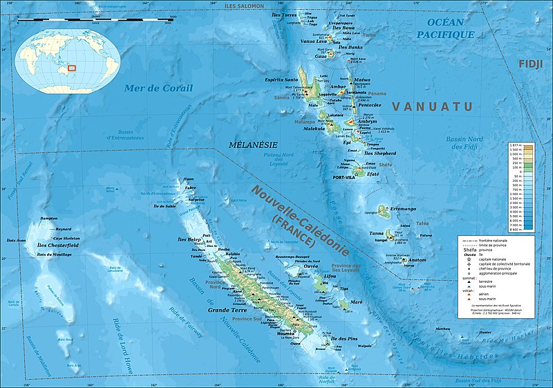
ଫାଇଲ:New Caledonia and Vanuatu bathymetric and topographic map-fr.jpg

ଏହି ଦେଖଣାର ଆକାର: ୮୦୦ × ୫୬୧ ପିକ୍ସେଲ । ବାକି ରେଜୋଲୁସନ: ୩୨୦ × ୨୨୪ ପିକ୍ସେଲ | ୬୪୦ × ୪୪୯ ପିକ୍ସେଲ | ୧,୦୨୪ × ୭୧୮ ପିକ୍ସେଲ | ୧,୨୮୦ × ୮୯୮ ପିକ୍ସେଲ | ୨,୫୬୦ × ୧,୭୯୫ ପିକ୍ସେଲ | ୨,୯୮୦ × ୨,୦୯୦ ପିକ୍ସେଲ.
ମୂଳ ଫାଇଲ (୨,୯୮୦ × ୨,୦୯୦ ପିକସେଲ, ଫାଇଲ ଆକାର: ୧.୫୩ MB, ଏମ.ଆଇ.ଏମ.ଇର ପ୍ରକାର: image/jpeg)
ଫାଇଲ ଇତିହାସ
ଏହା ଫାଇଲଟି ସେତେବେଳେ ଯେମିତି ଦିଶୁଥିଲା ତାହା ଦେଖିବା ପାଇଁ ତାରିଖ/ବେଳା ଉପରେ କ୍ଲିକ କରନ୍ତୁ
| ତାରିଖ/ବେଳ | ନଖ ଦେଖଣା | ଆକାର | ବ୍ୟବହାରକାରୀ | ମତାମତ | |
|---|---|---|---|---|---|
| ଏବେକାର | ୨୩:୧୦, ୧୯ ଡିସେମ୍ବର ୨୦୧୩ |  | ୨,୯୮୦ × ୨,୦୯୦ (୧.୫୩ MB) | Sting | Île de Sable removed (cf http://www.shom.fr/fileadmin/data-www/DMI/Communiques_de_presse/2012/COMMUNIQUE-DE-PRESSE-SANDY-ISLAND.doc) ; new elevation data used (SRTM30 Plus) |
| ୧୭:୦୮, ୩୦ ମଇ ୨୦୧୧ |  | ୨,୯୮୦ × ୨,୦୯୦ (୧.୪୬ MB) | Sting | Reverted to version as of 21:32, 16 July 2010 (sRGB profile) | |
| ୦୨:୧୦, ୧୮ ଜୁଲାଇ ୨୦୧୦ |  | ୨,୯୮୦ × ୨,୦୯୦ (୧.୩୫ MB) | Sting | Better unsaturated colors than over-saturated ones in non color managed browsers | |
| ୦୩:୦୨, ୧୭ ଜୁଲାଇ ୨୦୧୦ |  | ୨,୯୮୦ × ୨,୦୯୦ (୧.୪୬ MB) | Sting | Color profile correction | |
| ୦୪:୩୫, ୩୦ ଜୁନ ୨୦୧୦ |  | ୨,୯୮୦ × ୨,୦୯୦ (୧.୩୫ MB) | Sting | With sRGB color profile | |
| ୦୮:୪୨, ୧୭ ଫେବୃଆରୀ ୨୦୦୯ |  | ୨,୯୮୦ × ୨,୦୯୦ (୧.୩୯ MB) | Sting | == Summary == {{Location|18|30|00|S|166|00|00|E|scale:10000000}} <br/> {{Information |Description={{en|Bathymetric and topographic map of New Caledonia and Vanuatu, Oceania.}} {{fr|Carte bathymétrique |
ଫାଇଲ ବ୍ୟବହାର
ଏହି ଫାଇଲ ସହିତ ଯୋଡ଼ା ଗୋଟିଏ ବି ପୃଷ୍ଠା ନାହିଁ ।
ଜଗତ ଫାଇଲ ବ୍ୟବହାର
ତଳଲିଖିତ ଉଇକିସବୁ ଏହି ଫାଇଲଟିକୁ ବ୍ୟବହାର କରିଥାନ୍ତି:
- avk.wikipedia.orgରେ ବ୍ୟବହାର
- azb.wikipedia.orgରେ ବ୍ୟବହାର
- bg.wikipedia.orgରେ ବ୍ୟବହାର
- bi.wikipedia.orgରେ ବ୍ୟବହାର
- bs.wikinews.orgରେ ବ୍ୟବହାର
- en.wikipedia.orgରେ ବ୍ୟବହାର
- eo.wikipedia.orgରେ ବ୍ୟବହାର
- es.wikipedia.orgରେ ବ୍ୟବହାର
- fi.wikipedia.orgରେ ବ୍ୟବହାର
- fr.wikipedia.orgରେ ବ୍ୟବହାର
- Vanuatu
- Liste des colonies françaises
- Christian Zuber
- Nouvelle-Calédonie
- Référendum en France
- Projet:Cartographie/Cartes standards/Pays
- 2010 par pays en Océanie
- 2011 par pays en Océanie
- Rallye de Nouvelle-Calédonie
- Français océanien
- Utilisateur:Exp JC/Brouillon
- Environnement en Nouvelle-Calédonie
- 2010 en Nouvelle-Calédonie
- 2011 au Vanuatu
- 2010 au Vanuatu
- fr.wikinews.orgରେ ବ୍ୟବହାର
- fr.wikiversity.orgରେ ବ୍ୟବହାର
- gcr.wikipedia.orgରେ ବ୍ୟବହାର
- gl.wikipedia.orgରେ ବ୍ୟବହାର
- he.wikipedia.orgରେ ବ୍ୟବହାର
- hu.wikipedia.orgରେ ବ୍ୟବହାର
- ky.wikipedia.orgରେ ବ୍ୟବହାର
- la.wikipedia.orgରେ ବ୍ୟବହାର
- lfn.wikipedia.orgରେ ବ୍ୟବହାର
- nl.wikipedia.orgରେ ବ୍ୟବହାର
- nn.wikipedia.orgରେ ବ୍ୟବହାର
- oc.wikipedia.orgରେ ବ୍ୟବହାର
- pl.wikipedia.orgରେ ବ୍ୟବହାର
- pl.wikivoyage.orgରେ ବ୍ୟବହାର
- pt.wikipedia.orgରେ ବ୍ୟବହାର
ଏହି ଫାଇଲଟିର ଅଧିକ ବିଶ୍ୱବ୍ୟାପୀ ବ୍ୟବହାର ଦେଖନ୍ତୁ ।


