
ଫାଇଲ:Map of Michigan highlighting Tuscola County.svg

Size of this PNG preview of this SVG file: ୫୧୨ × ୬୦୦ ପିକ୍ସେଲ. ବାକି ରେଜୋଲୁସନ: ୨୦୫ × ୨୪୦ ପିକ୍ସେଲ | ୪୧୦ × ୪୮୦ ପିକ୍ସେଲ | ୬୫୫ × ୭୬୮ ପିକ୍ସେଲ | ୮୭୪ × ୧,୦୨୪ ପିକ୍ସେଲ | ୧,୭୪୮ × ୨,୦୪୮ ପିକ୍ସେଲ | ୯୬୨ × ୧,୧୨୭ ପିକ୍ସେଲ.
ମୂଳ ଫାଇଲ (SVG ଫାଇଲ, ସାଧାରଣ ମାପ ୯୬୨ × ୧,୧୨୭ ପିକ୍ସେଲ, ଫାଇଲ ଆକାର: ୧୩୮ KB)
This is a file from the Wikimedia Commons. Information from its description page there is shown below. |
ସାରକଥା
| ବିବରଣୀ |
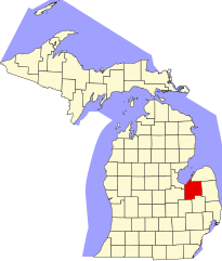
English: This is a locator map showing Tuscola County in Michigan. For more information, see Commons:United States county locator maps. |
| ତାରିଖ | |
| ମୂଳାଧାର |
ଆପଣା କାମ: English: The maps use data from nationalatlas.gov, specifically countyp020.tar.gz on the Raw Data Download page. The maps also use state outline data from statesp020.tar.gz. The Florida maps use hydrogm020.tar.gz to display Lake Okeechobee. |
| ଲେଖକ | David Benbennick |
ସତ୍ଵ
| ମୁଁ, ଏହି କାମର ସତ୍ଵାଧିକାରୀ, ଏହାକୁ ପବ୍ଲିକ ଡୋମେନରେ ଏହାକୁ ପ୍ରକାଶ କରୁଛି । ଏହା ଜଗତଯାକ ପାଇଁ ଲାଗୁ । କେତେକ ଦେଶରେ ଏହା ନ୍ୟାୟମତେ ଅନୁମୋଦିତ ହୋଇନପାରେ, ଯଦି ସେମିତି ହୁଏ: ମୁଁ, ଯେ ପର୍ଯ୍ୟନ୍ତ ଆଇନରେ କିଛି ସର୍ତ୍ତ ଦରକାର ନ ପଡ଼େ ସେ ପର୍ଯ୍ୟନ୍ତ ସଭିଙ୍କୁ କୌଣସି ବି ଉଦ୍ଦେଶ୍ୟରେ ଏହ କାମଟିକୁ ନିସର୍ତ୍ତ ବ୍ୟବହାର କରିବାକୁ ଅନୁମତି ଦେଉଛି । |
ଫାଇଲ ଇତିହାସ
ଏହା ଫାଇଲଟି ସେତେବେଳେ ଯେମିତି ଦିଶୁଥିଲା ତାହା ଦେଖିବା ପାଇଁ ତାରିଖ/ବେଳା ଉପରେ କ୍ଲିକ କରନ୍ତୁ
| ତାରିଖ/ବେଳ | ନଖ ଦେଖଣା | ଆକାର | ବ୍ୟବହାରକାରୀ | ମତାମତ | |
|---|---|---|---|---|---|
| ଏବେକାର | ୧୫:୫୭, ୨୫ ଜୁନ ୨୦୨୪ | | ୯୬୨ × ୧,୧୨୭ (୧୩୮ KB) | Nux | fix rendering (remove clipping) |
| ୧୮:୩୦, ୧୨ ଫେବୃଆରୀ ୨୦୦୬ |  | ୬,୨୫୬ × ୭,୩୨୫ (୨୦୫ KB) | David Benbennick | {{subst:User:Dbenbenn/clm|county=Tuscola County|state=Michigan|type=county}} |
ଫାଇଲ ବ୍ୟବହାର
ଏହି ଫାଇଲ ସହିତ ଯୋଡ଼ା ଗୋଟିଏ ବି ପୃଷ୍ଠା ନାହିଁ ।
ଜଗତ ଫାଇଲ ବ୍ୟବହାର
ତଳଲିଖିତ ଉଇକିସବୁ ଏହି ଫାଇଲଟିକୁ ବ୍ୟବହାର କରିଥାନ୍ତି:
- ar.wikipedia.orgରେ ବ୍ୟବହାର
- مقاطعة توسكولا (ميشيغان)
- فاسار
- بلدة أكرون (ميشيغان)
- بلدة ألمر (ميشيغان)
- بلدة أربيلا (ميشيغان)
- بلدة كولومبيا (مقاطعة توسكولا)
- بلدة دايتون (مقاطعة توسكولا)
- بلدة دنمارك (ميشيغان)
- بلدة إلكلاند (ميشيغان)
- بلدة إلينغتون (ميشيغان)
- بلدة إلموود (ميشيغان)
- بلدة فيرغروف (ميشيغان)
- بلدة فريمونت (مقاطعة توسكولا)
- بلدة جيلفورد (ميشيغان)
- بلدة إنديانفيلدز (ميشيغان)
- بلدة جونياتا (ميشيغان)
- بلدة كينغستون (ميشيغان)
- بلدة كويلتون (ميشيغان)
- بلدة ميلنغتون (ميشيغان)
- بلدة نوفستا (ميشيغان)
- بلدة توسكولا (ميشيغان)
- بلدة فاسار (ميشيغان)
- بلدة ووترتاون (مقاطعة توسكولا)
- بلدة ويلز (مقاطعة توسكولا)
- بلدة ويزنر (ميشيغان)
- أكرون (ميشيغان)
- جاجتاون (ميشيغان)
- ريسي (ميشيغان)
- فيرغروف (ميشيغان)
- كاس سيتي (ميشيغان)
- كينغستون (ميشيغان)
- مافيل (ميشيغان)
- ميلينغتون (ميشيغان)
- يونيونفيل (ميشيغان)
- قالب:مقاطعة توسكولا (ميشيغان)
- bg.wikipedia.orgରେ ବ୍ୟବହାର
- bpy.wikipedia.orgରେ ବ୍ୟବହାର
- cdo.wikipedia.orgରେ ବ୍ୟବହାର
- ceb.wikipedia.orgରେ ବ୍ୟବହାର
- cs.wikipedia.orgରେ ବ୍ୟବହାର
- cy.wikipedia.orgରେ ବ୍ୟବହାର
- de.wikipedia.orgରେ ବ୍ୟବହାର
- en.wikipedia.orgରେ ବ୍ୟବହାର
ଏହି ଫାଇଲଟିର ଅଧିକ ବିଶ୍ୱବ୍ୟାପୀ ବ୍ୟବହାର ଦେଖନ୍ତୁ ।