
ଫାଇଲ:Kargil.map.gif
ବଡ଼ ରେଜୋଲୁସନ ନାହିଁ ।
Kargil.map.gif (୪୨୮ × ୩୯୬ ପିକସେଲ, ଫାଇଲ ଆକାର: ୧୧ KB, ଏମ.ଆଇ.ଏମ.ଇର ପ୍ରକାର: image/gif)
This is a file from the Wikimedia Commons. Information from its description page there is shown below. |

|
This locator map image could be re-created using vector graphics as an SVG file. This has several advantages; see Commons:Media for cleanup for more information. If an SVG form of this image is available, please upload it and afterwards replace this template with
{{vector version available|new image name}}.
It is recommended to name the SVG file “Kargil.map.svg”—then the template Vector version available (or Vva) does not need the new image name parameter. |
This file is a work of a sailor or employee of the U.S. Navy, taken or made as part of that person's official duties. As a work of the U.S. federal government, it is in the public domain in the United States.
|
 | |
| ଏହି ଫାଇଲଟିକୁ ସବୁ ସମ୍ଭନ୍ଧିତ ଓ ପାଖାପାଖି ନୀତି ଅନୁସାଅରେ ସତ୍ଵାଧିକାର ନୀତି ଅନୁସାରେ ସମସ୍ତ କଟକଣାରୁ କୋହଳ କରାଯାଇଛି । | ||
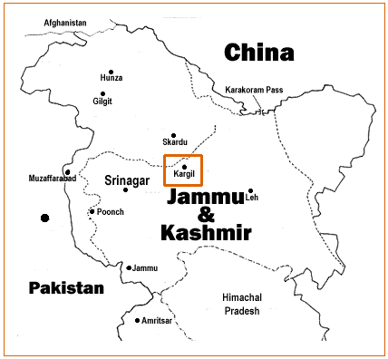
Source: http://www.ccc.nps.navy.mil/research/kargil/index.asp
Geo-political location of Kargil.
derivative works
Derivative works of this file:
ଫାଇଲ ଇତିହାସ
ଏହା ଫାଇଲଟି ସେତେବେଳେ ଯେମିତି ଦିଶୁଥିଲା ତାହା ଦେଖିବା ପାଇଁ ତାରିଖ/ବେଳା ଉପରେ କ୍ଲିକ କରନ୍ତୁ
| ତାରିଖ/ବେଳ | ନଖ ଦେଖଣା | ଆକାର | ବ୍ୟବହାରକାରୀ | ମତାମତ | |
|---|---|---|---|---|---|
| ଏବେକାର | ୧୩:୩୯, ୧୯ ଅପ୍ରେଲ ୨୦୦୭ | | ୪୨୮ × ୩୯୬ (୧୧ KB) | A3A3A3A | {{PD-USGov-Military-Navy}} Source: http://www.ccc.nps.navy.mil/research/kargil/index.asp Geo-political location of Kargil. |
ଫାଇଲ ବ୍ୟବହାର
ଏହି ଫାଇଲ ସହିତ ଯୋଡ଼ା ଗୋଟିଏ ବି ପୃଷ୍ଠା ନାହିଁ ।
ଜଗତ ଫାଇଲ ବ୍ୟବହାର
ତଳଲିଖିତ ଉଇକିସବୁ ଏହି ଫାଇଲଟିକୁ ବ୍ୟବହାର କରିଥାନ୍ତି:
- as.wikipedia.orgରେ ବ୍ୟବହାର
- azb.wikipedia.orgରେ ବ୍ୟବହାର
- az.wikipedia.orgରେ ବ୍ୟବହାର
- be-tarask.wikipedia.orgରେ ବ୍ୟବହାର
- be.wikipedia.orgରେ ବ୍ୟବହାର
- bn.wikipedia.orgରେ ବ୍ୟବହାର
- ca.wikipedia.orgରେ ବ୍ୟବହାର
- cs.wikipedia.orgରେ ବ୍ୟବହାର
- en.wikipedia.orgରେ ବ୍ୟବହାର
- es.wikipedia.orgରେ ବ୍ୟବହାର
- fa.wikipedia.orgରେ ବ୍ୟବହାର
- gu.wikipedia.orgରେ ବ୍ୟବହାର
- id.wikipedia.orgରେ ବ୍ୟବହାର
- it.wikipedia.orgରେ ବ୍ୟବହାର
- ka.wikipedia.orgରେ ବ୍ୟବହାର
- kn.wikipedia.orgରେ ବ୍ୟବହାର
- ko.wikipedia.orgରେ ବ୍ୟବହାର
- ml.wikipedia.orgରେ ବ୍ୟବହାର
- ne.wikipedia.orgରେ ବ୍ୟବହାର
- nl.wikipedia.orgରେ ବ୍ୟବହାର
- pnb.wikipedia.orgରେ ବ୍ୟବହାର
- pt.wikipedia.orgରେ ବ୍ୟବହାର
- ru.wikipedia.orgରେ ବ୍ୟବହାର
- sat.wikipedia.orgରେ ବ୍ୟବହାର
- sd.wikipedia.orgରେ ବ୍ୟବହାର
- sr.wikipedia.orgରେ ବ୍ୟବହାର
- ta.wikipedia.orgରେ ବ୍ୟବହାର
- te.wikipedia.orgରେ ବ୍ୟବହାର
- tr.wikipedia.orgରେ ବ୍ୟବହାର
- uk.wikipedia.orgରେ ବ୍ୟବହାର
- uz.wikipedia.orgରେ ବ୍ୟବହାର
- www.wikidata.orgରେ ବ୍ୟବହାର
- zh.wikipedia.orgରେ ବ୍ୟବହାର