
ଫାଇଲ:India Punjab location map.svg

ମୂଳ ଫାଇଲ (SVG ଫାଇଲ, ସାଧାରଣ ମାପ ୯୭୯ × ୧,୦୮୬ ପିକ୍ସେଲ, ଫାଇଲ ଆକାର: ୩୧୧ KB)
This is a file from the Wikimedia Commons. Information from its description page there is shown below. |
ସାରକଥା
| ବିବରଣୀ |
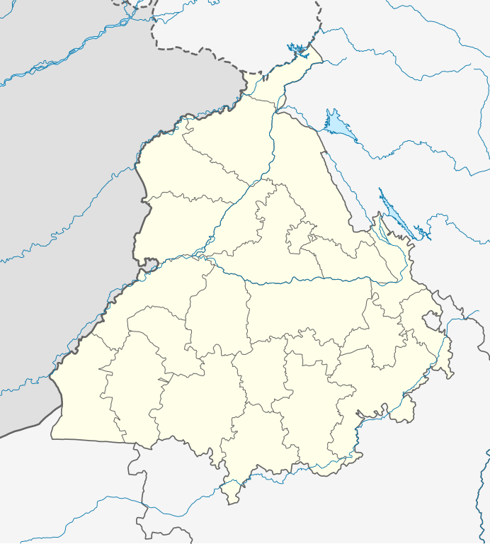
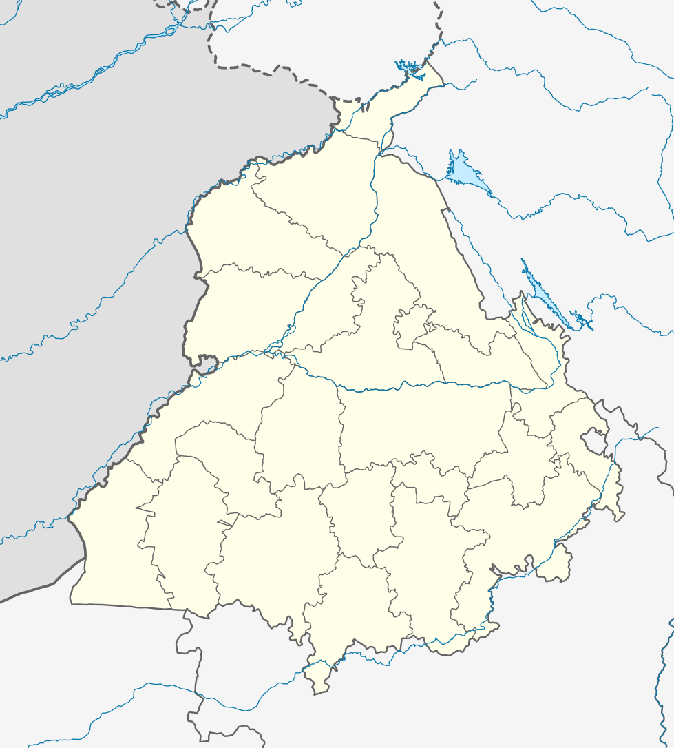
Quadratische Plattkarte, N-S-Streckung 117 %. Geographische Begrenzung der Karte:
Equirectangular projection, N/S stretching 117 %. Geographic limits of the map:
|
|
| ତାରିଖ | ||
| ମୂଳାଧାର |
ଆପଣା କାମ, using
|
|
| ଲେଖକ | NordNordWest | |
| ଅନୁମତି (ଏହି ଫାଇଲକୁ ପୁଣି ବ୍ୟବହାର କରିବେ) |
ଏହି ଫାଇଲଟି କ୍ରିଏଟିଭ କମନ୍ସ ଅଧୀନରେ ଆଟ୍ରିବୁସନ ସେଆର-ଏଲାଇକ ୩.୦ ଜର୍ମାନୀ ଲାଇସେନ୍ସରେ ପଞ୍ଜିକରଣ କରାଯାଇଅଛି ।
 ଏହି ଫାଇଲଟି କ୍ରିଏଟିଭ କମନ୍ସ ଅଧୀନରେ ଆଟ୍ରିବୁସନ ସେଆର-ଏଲାଇକ ୩.୦ ଜର୍ମାନୀ ଲାଇସେନ୍ସରେ ପଞ୍ଜିକରଣ କରାଯାଇଅଛି ।
|


|
This map has been made or improved in the German Kartenwerkstatt (Map Lab). You can propose maps to improve as well.
|
ଫାଇଲ ଇତିହାସ
ଏହା ଫାଇଲଟି ସେତେବେଳେ ଯେମିତି ଦିଶୁଥିଲା ତାହା ଦେଖିବା ପାଇଁ ତାରିଖ/ବେଳା ଉପରେ କ୍ଲିକ କରନ୍ତୁ
| ତାରିଖ/ବେଳ | ନଖ ଦେଖଣା | ଆକାର | ବ୍ୟବହାରକାରୀ | ମତାମତ | |
|---|---|---|---|---|---|
| ଏବେକାର | ୦୯:୪୯, ୧୯ ଅଗଷ୍ଟ ୨୦୨୨ | | ୯୭୯ × ୧,୦୮୬ (୩୧୧ KB) | C1MM | Fixed Ludhiana district |
| ୦୯:୩୩, ୧୯ ଅଗଷ୍ଟ ୨୦୨୨ |  | ୯୭୯ × ୧,୦୮୬ (୩୧୨ KB) | C1MM | Resized to original size | |
| ୦୯:୨୭, ୧୯ ଅଗଷ୍ଟ ୨୦୨୨ |  | ୯୫୧ × ୮୯୮ (୩୨୪ KB) | C1MM | Added Malerkotla district, fixed rivers and disputed boundaries for Jammu and Kashmir | |
| ୦୮:୫୩, ୧୫ ଜାନୁଆରୀ ୨୦୨୧ |  | ୧,୦୪୯ × ୧,୧୬୧ (୧୧୪ KB) | C1MM | Added Tan Taran district | |
| ୨୩:୪୧, ୨୪ ଅକ୍ଟୋବର ୨୦୨୦ |  | ୧,୦୪୯ × ୧,୧୬୧ (୧୧୦ KB) | C1MM | Updated districts | |
| ୨୩:୧୧, ୪ ମଇ ୨୦୧୨ |  | ୧,୦୪୯ × ୧,୧୬୧ (୧୦୭ KB) | NordNordWest | upd | |
| ୦୧:୫୪, ୨୦ ମଇ ୨୦୧୦ |  | ୧,୦୪୯ × ୧,୧୬୧ (୧୦୪ KB) | NordNordWest | c | |
| ୦୧:୪୧, ୨୦ ମଇ ୨୦୧୦ |  | ୧,୦୪୯ × ୧,୧୬୧ (୧୦୫ KB) | NordNordWest | =={{int:filedesc}}== {{Information |Description= {{de|Positionskarte von Punjab, Indien}} Quadratische Plattkarte, N-S-Streckung 117 %. Geographische Begrenzung der Karte: * N: 32.8° N * S: 29.3° N * W: 73.5° O * |
ଫାଇଲ ବ୍ୟବହାର
ଏହି ସବୁ5 ପୃଷ୍ଠାସବୁ ଏହି ଫାଇଲଟିକୁ ଯୋଡ଼ିଥାନ୍ତି:
ଜଗତ ଫାଇଲ ବ୍ୟବହାର
ତଳଲିଖିତ ଉଇକିସବୁ ଏହି ଫାଇଲଟିକୁ ବ୍ୟବହାର କରିଥାନ୍ତି:
- ar.wikipedia.orgରେ ବ୍ୟବହାର
- as.wikipedia.orgରେ ବ୍ୟବହାର
- azb.wikipedia.orgରେ ବ୍ୟବହାର
- علیپور-۲
- علیپور-۱
- علی چاک
- علادینپور
- علیخل، جالاندر
- فول ماکاوری
- فیالی (هیندوستان)
- فاروالا, جالاندهار
- فارالا
- فانقوتا
- فامبرا
- فالپوتا
- ساروپوال
- ساروپوال, سولطانپور لودهی
- سارتی, قورداسپور
- سارنانا
- سارینه, لودهیانا
- سارینه, جالاندهار
- سارهالی
- سارهالی, جالاندهار
- سارهال کازیان
- سارهال موندی
- سارقوندی
- سارانقوال
- سارانقرا
- سارای خاس
- سارای خام
- سارای جاتان
- ساپرور
- مدا, پنجاب
- مازاری, اسبیاس ناقار
- مازارا ناو آباد
- مازارا خورد
- مازارا کالان
- سانورا
- ماوای, جالاندهار
- ماولی, فاقوارا
- ماوجیا
- ماو, پنجاب
- ماتوی, پنجاب
- سانقرای
- سانقرا, سولطانپور لودهی
- سانقووال
- سانقوجلا
- سانقول
- سانقرا (کند)
ଏହି ଫାଇଲଟିର ଅଧିକ ବିଶ୍ୱବ୍ୟାପୀ ବ୍ୟବହାର ଦେଖନ୍ତୁ ।