
ଫାଇଲ:Proposed states and territories of India.png
ଏହି ଦେଖଣାର ଆକାର: ୫୬୯ × ୬୦୦ ପିକ୍ସେଲ । ବାକି ରେଜୋଲୁସନ: ୨୨୮ × ୨୪୦ ପିକ୍ସେଲ | ୪୫୫ × ୪୮୦ ପିକ୍ସେଲ | ୭୨୮ × ୭୬୮ ପିକ୍ସେଲ | ୯୭୧ × ୧,୦୨୪ ପିକ୍ସେଲ | ୧,୪୫୬ × ୧,୫୩୫ ପିକ୍ସେଲ.
ମୂଳ ଫାଇଲ (୧,୪୫୬ × ୧,୫୩୫ ପିକସେଲ, ଫାଇଲ ଆକାର: ୩୩୨ KB, ଏମ.ଆଇ.ଏମ.ଇର ପ୍ରକାର: image/png)
This is a file from the Wikimedia Commons. Information from its description page there is shown below. |

|
File:Proposed states and union territories of India.svg is a vector version of this file. It should be used in place of this PNG file when not inferior.
File:Proposed states and territories of India.png → File:Proposed states and union territories of India.svg
For more information, see Help:SVG. |
 |
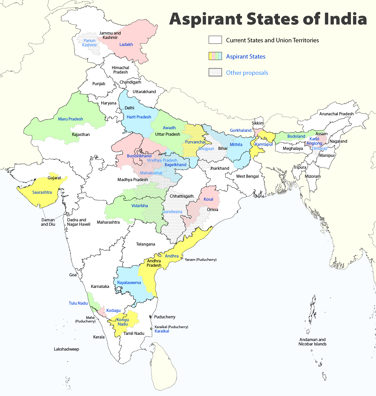
| ବିବରଣୀ |
Deutsch: Indiens Anwärterstaaten
English: Aspirant States of India |
| ତାରିଖ | |
| ମୂଳାଧାର | ଆପଣା କାମ |
| ଲେଖକ | Maximilian Dörrbecker (Chumwa) |
| ଅନୁମତି (ଏହି ଫାଇଲକୁ ପୁଣି ବ୍ୟବହାର କରିବେ) |
ମୁଁ, ଏହି କାମର ସତ୍ଵାଧିକାରୀ, ଏଠାରେ ତଳଲିଖିତ ଲାଇସେନ୍ସ ଅଧୀନରେ ଏହାକୁ ପ୍ରକାଶ କଲି: ଏହି ଫାଇଲଟି କ୍ରିଏଟିଭ କମନ୍ସ ଅଧୀନରେ ଆଟ୍ରିବୁସନ ସେଆର-ଏଲାଇକ ୨.୫ ଜେନେରିକ ଲାଇସେନ୍ସରେ ପଞ୍ଜିକରଣ କରାଯାଇଅଛି ।
Sie dürfen das Bild zu den folgenden Bedingungen nutzen:
|
| ଅନ୍ୟ ସଂସ୍କରଣ |
|

ଫାଇଲ ଇତିହାସ
ଏହା ଫାଇଲଟି ସେତେବେଳେ ଯେମିତି ଦିଶୁଥିଲା ତାହା ଦେଖିବା ପାଇଁ ତାରିଖ/ବେଳା ଉପରେ କ୍ଲିକ କରନ୍ତୁ
| ତାରିଖ/ବେଳ | ନଖ ଦେଖଣା | ଆକାର | ବ୍ୟବହାରକାରୀ | ମତାମତ | |
|---|---|---|---|---|---|
| ଏବେକାର | ୧୪:୩୬, ୨ ଅଗଷ୍ଟ ୨୦୨୦ | | ୧,୪୫୬ × ୧,୫୩୫ (୩୩୨ KB) | Chumwa | Reverted to version as of 21:03, 29 August 2018 (UTC) |
| ୦୧:୩୩, ୩୧ ଜୁଲାଇ ୨୦୨୦ |  | ୧,୪୫୬ × ୧,୫୩୫ (୩୧୬ KB) | UT'sIndia | Reverted to version as of 15:15, 17 May 2013 (UTC) | |
| ୦୨:୩୩, ୩୦ ଅଗଷ୍ଟ ୨୦୧୮ |  | ୧,୪୫୬ × ୧,୫୩୫ (୩୩୨ KB) | Chumwa | extended Tulu Nadu into Kerala | |
| ୦୩:୨୨, ୬ ଜୁନ ୨୦୧୪ |  | ୧,୪୫୬ × ୧,୫୩୫ (୩୩୨ KB) | Chumwa | borders of Rayalseema corrected | |
| ୨୩:୫୩, ୩ ଜୁନ ୨୦୧୪ |  | ୧,୪୫୬ × ୧,୫୩୫ (୩୩୨ KB) | Chumwa | borders of Mithila corrected | |
| ୨୩:୨୩, ୩ ଜୁନ ୨୦୧୪ |  | ୧,୪୫୬ × ୧,୫୩୫ (୩୩୧ KB) | Chumwa | Telangana now is an official state | |
| ୨୦:୪୬, ୧୭ ମଇ ୨୦୧୩ |  | ୧,୪୫୬ × ୧,୫୩୫ (୩୧୬ KB) | Cromium | Removed large title; enlarged map key with slightly different wording | |
| ୨୦:୪୫, ୧୭ ମଇ ୨୦୧୩ |  | ୧,୪୫୬ × ୧,୫୩୫ (୩୧୬ KB) | Cromium | Removed large title; enlarged map key with slightly different wording | |
| ୦୪:୦୨, ୩ ଜାନୁଆରୀ ୨୦୧୨ |  | ୧,୪୫୬ × ୧,୫୩୫ (୩୧୨ KB) | Chumwa | added some other aspirant states | |
| ୦୨:୪୬, ୩ ଜାନୁଆରୀ ୨୦୧୨ |  | ୧,୪୫୬ × ୧,୫୩୫ (୨୯୨ KB) | Chumwa | added a map key |
ଫାଇଲ ବ୍ୟବହାର
ଏହି ସବୁପୃଷ୍ଠା ଏହି ଫାଇଲଟିକୁ ଯୋଡ଼ିଥାନ୍ତି:
ଜଗତ ଫାଇଲ ବ୍ୟବହାର
ତଳଲିଖିତ ଉଇକିସବୁ ଏହି ଫାଇଲଟିକୁ ବ୍ୟବହାର କରିଥାନ୍ତି:
- bn.wikipedia.orgରେ ବ୍ୟବହାର
- de.wikipedia.orgରେ ବ୍ୟବହାର
- en.wikipedia.orgରେ ବ୍ୟବହାର
- Delhi
- Gondwana (India)
- Kodagu district
- Mithila (proposed Indian state)
- Awadh
- Vidarbha
- Bundelkhand
- Bagelkhand
- Tulu Nadu
- Rayalaseema
- Purvanchal
- Bodoland Territorial Region
- Karbi Anglong district
- Mahakoshal
- Kongu Nadu
- Cooch Behar district
- Gird, India
- Mara Autonomous District Council
- Tripura Tribal Areas Autonomous District Council
- Malabar District
- Gorkhaland movement
- Kamtapur
- Proposed states and union territories of India
- Autonomous administrative divisions of India
- Karaikal district
- Panun Kashmir
- Chakma Autonomous District Council
- Lai Autonomous District Council
- Khasi Hills Autonomous District Council
- Jaintia Hills Autonomous District Council
- Garo Hills Autonomous District Council
- Template:Proposed states and union territories of India
- Tulu Nadu state movement
- Kosal state movement
- User:AbhisheksinghWIKI/Law and Order(India)
- Gorkhaland Territorial Administration
- Tipraland
- Kalyana-Karnataka
- Sadar Hills
- West Karbi Anglong district
ଏହି ଫାଇଲଟିର ଅଧିକ ବିଶ୍ୱବ୍ୟାପୀ ବ୍ୟବହାର ଦେଖନ୍ତୁ ।