
ଫାଇଲ:Chota Nagpur area-IGI.jpg
ଏହି ଦେଖଣାର ଆକାର: ୮୦୦ × ୪୬୯ ପିକ୍ସେଲ । ବାକି ରେଜୋଲୁସନ: ୩୨୦ × ୧୮୮ ପିକ୍ସେଲ | ୬୪୦ × ୩୭୫ ପିକ୍ସେଲ | ୧,୧୦୩ × ୬୪୭ ପିକ୍ସେଲ.
ମୂଳ ଫାଇଲ (୧,୧୦୩ × ୬୪୭ ପିକସେଲ, ଫାଇଲ ଆକାର: ୧୪୮ KB, ଏମ.ଆଇ.ଏମ.ଇର ପ୍ରକାର: image/jpeg)
This is a file from the Wikimedia Commons. Information from its description page there is shown below. |
ସାରକଥା
| ବିବରଣୀ |
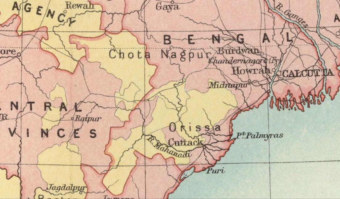
English: Chota Nagpur Plateau. Political Divisions. 1909 Imperial Gazetteer of India map section. |
| ତାରିଖ | |
| ମୂଳାଧାର | Imperial Gazetteer of India 1909 |
| ଲେଖକ | Great Britain India Office |
ସତ୍ଵ
This media file is in the public domain in the United States. This applies to U.S. works where the copyright has expired, often because its first publication occurred prior to January 1, 1929, and if not then due to lack of notice or renewal. See this page for further explanation.
|
 | |
 |
This image might not be in the public domain outside of the United States; this especially applies in the countries and areas that do not apply the rule of the shorter term for US works, such as Canada, Mainland China (not Hong Kong or Macao), Germany, Mexico, and Switzerland. The creator and year of publication are essential information and must be provided. See Wikipedia:Public domain and Wikipedia:Copyrights for more details.
|
ଫାଇଲ ଇତିହାସ
ଏହା ଫାଇଲଟି ସେତେବେଳେ ଯେମିତି ଦିଶୁଥିଲା ତାହା ଦେଖିବା ପାଇଁ ତାରିଖ/ବେଳା ଉପରେ କ୍ଲିକ କରନ୍ତୁ
| ତାରିଖ/ବେଳ | ନଖ ଦେଖଣା | ଆକାର | ବ୍ୟବହାରକାରୀ | ମତାମତ | |
|---|---|---|---|---|---|
| ଏବେକାର | ୧୯:୦୪, ୧୫ ଅକ୍ଟୋବର ୨୦୧୫ | | ୧,୧୦୩ × ୬୪୭ (୧୪୮ KB) | Xufanc | User created page with UploadWizard |
ଫାଇଲ ବ୍ୟବହାର
ଏହି ସବୁପୃଷ୍ଠା ଏହି ଫାଇଲଟିକୁ ଯୋଡ଼ିଥାନ୍ତି:
ଜଗତ ଫାଇଲ ବ୍ୟବହାର
ତଳଲିଖିତ ଉଇକିସବୁ ଏହି ଫାଇଲଟିକୁ ବ୍ୟବହାର କରିଥାନ୍ତି:
- bn.wikipedia.orgରେ ବ୍ୟବହାର
- ca.wikipedia.orgରେ ବ୍ୟବହାର
- en.wikipedia.orgରେ ବ୍ୟବହାର
- hi.wikipedia.orgରେ ବ୍ୟବହାର