"କଲିକତା" ପୃଷ୍ଠାର ସଂସ୍କରଣଗୁଡ଼ିକ ମଧ୍ୟରେ ତଫାତ
Content deleted Content added
ଟିକେ r2.6.4) (robot Adding: ext:Calcuta |
ଟିକେ robot Adding: ku:Kolkata Removing: nap:Calcutta (deleted) |
||
| ୯୪ କ ଧାଡ଼ି: | ୯୪ କ ଧାଡ଼ି: | ||
[[ko:콜카타]] |
[[ko:콜카타]] |
||
[[ks:कलकाता]] |
[[ks:कलकाता]] |
||
[[ku:Kolkata]] |
|||
[[kw:Kolkata]] |
[[kw:Kolkata]] |
||
[[la:Colcata]] |
[[la:Colcata]] |
||
| ୧୦୫ କ ଧାଡ଼ି: | ୧୦୬ କ ଧାଡ଼ି: | ||
[[ms:Kolkata]] |
[[ms:Kolkata]] |
||
[[my:ကာလကတ္တားမြို့]] |
[[my:ကာလကတ္တားမြို့]] |
||
[[nap:Calcutta]] |
|||
[[ne:कोलकाता]] |
[[ne:कोलकाता]] |
||
[[new:कोलकाता]] |
[[new:कोलकाता]] |
||
୧୮:୩୪, ୧୨ ଅଗଷ୍ଟ ୨୦୧୧ ଅନୁସାରେ କରାଯାଇଥିବା ବଦଳ
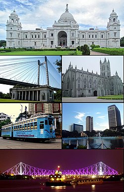
| କଲିକତା (কলকাতা) | |
| "The City of Joy" ; "The City of Palaces" (archaic) | |
| — Metropolitan City — | |
 | |
| ଦିଗବାରେଣି | 22°34′11″N 88°22′11″E / 22.56972°N 88.36972°E |
| ଦେଶ | ଭାରତ |
| ରାଜ୍ୟ | West Bengal |
| ଭାରତର ଜିଲାସବୁ | Calcutta † |
| Mayor | Sovan Chatterjee |
| ଲୋକସଂଖ୍ୟା |
୫,୧୩୮,୨୦୮[୧] (4th) (2010[update]) • 27,462/km2 (71,126/sq mi) |
| Spoken languages | |
|---|---|
| ଜାତିଗତ ଗୋଠ | |
| ସମୟ ଜୋନ | ଆ.ଏସ.ଟି (ୟୁଟିସି +୫.୩୦) |
| ପରିସୀମା |
1,480 square kilometres (570 sq mi) • 9 metres (30 ft) |
ପାଦଟୀକା
| |
| ବେବସାଇଟ | Kolkatamycity.com |
କଲିକତା ପଶ୍ଚିମବଙ୍ଗର ରାଜଧାନୀ |
References
- ↑ "India: largest cities and towns and statistics of their population". World Gazetteer. Retrieved 10 March 2010.
- ↑ "India: metropolitan areas". World Gazetteer. Retrieved 10 March 2010.
- ↑ Official Language - Constitutional/Statutory Provisions World Gazetteer. Retrieved 8 February 2010.
Bold text


