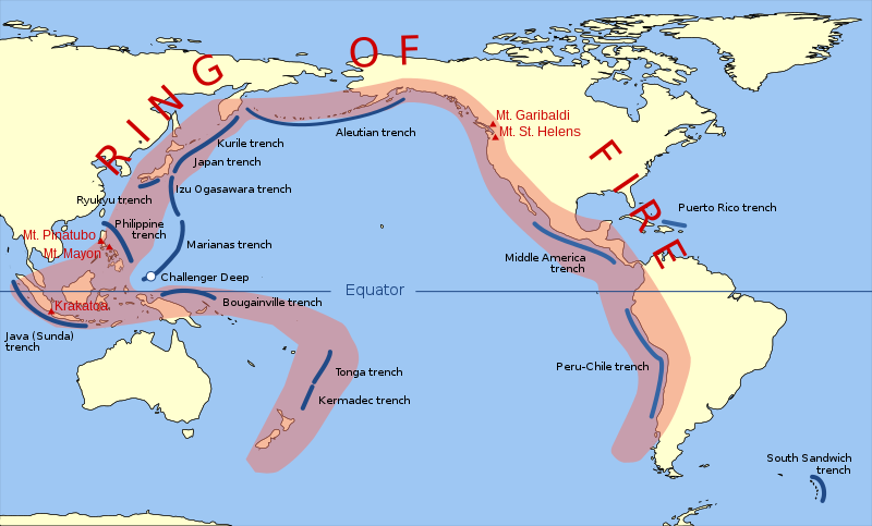
ଫାଇଲ:Pacific Ring of Fire.svg

Size of this PNG preview of this SVG file: ୮୦୦ × ୪୮୩ ପିକ୍ସେଲ. ବାକି ରେଜୋଲୁସନ: ୩୨୦ × ୧୯୩ ପିକ୍ସେଲ | ୬୪୦ × ୩୮୭ ପିକ୍ସେଲ | ୧,୦୨୪ × ୬୧୯ ପିକ୍ସେଲ | ୧,୨୮୦ × ୭୭୩ ପିକ୍ସେଲ | ୨,୫୬୦ × ୧,୫୪୬ ପିକ୍ସେଲ | ୯୪୨ × ୫୬୯ ପିକ୍ସେଲ.
ମୂଳ ଫାଇଲ (SVG ଫାଇଲ, ସାଧାରଣ ମାପ ୯୪୨ × ୫୬୯ ପିକ୍ସେଲ, ଫାଇଲ ଆକାର: ୨୯୪ KB)
ଫାଇଲ ଇତିହାସ
ଏହା ଫାଇଲଟି ସେତେବେଳେ ଯେମିତି ଦିଶୁଥିଲା ତାହା ଦେଖିବା ପାଇଁ ତାରିଖ/ବେଳା ଉପରେ କ୍ଲିକ କରନ୍ତୁ
| ତାରିଖ/ବେଳ | ନଖ ଦେଖଣା | ଆକାର | ବ୍ୟବହାରକାରୀ | ମତାମତ | |
|---|---|---|---|---|---|
| ଏବେକାର | ୧୭:୦୦, ୨୦ ମାର୍ଚ୍ଚ ୨୦୧୫ |  | ୯୪୨ × ୫୬୯ (୨୯୪ KB) | Szczureq | Ryuku → Ryukyu |
| ୧୮:୪୯, ୧୫ ମାର୍ଚ୍ଚ ୨୦୧୧ |  | ୯୪୨ × ୫୬୯ (୨୯୪ KB) | AnonMoos | trimming transparent margins | |
| ୦୦:୫୫, ୪ ମାର୍ଚ୍ଚ ୨୦୦୯ |  | ୭୯୬ × ୪୭୨ (୩୧୪ KB) | Kmusser | Fix volanco symbols | |
| ୦୦:୩୪, ୪ ମାର୍ଚ୍ଚ ୨୦୦୯ |  | ୭୯୬ × ୪୭୨ (୩୧୭ KB) | Kmusser | repositioned volcanoes | |
| ୦୪:୫୪, ୧୪ ଫେବୃଆରୀ ୨୦୦୯ |  | ୭୮୧ × ୪୭୨ (୧୪୫ KB) | Inductiveload | added volcanos | |
| ୨୨:୪୮, ୧୧ ଫେବୃଆରୀ ୨୦୦୯ |  | ୭୮୧ × ୪୭୨ (୧୩୮ KB) | Inductiveload | added labels, aluetian isles and south sandwich islands, as these are associated with the nearby trenches. also put everything into layers. | |
| ୦୫:୨୮, ୧୧ ଫେବୃଆରୀ ୨୦୦୯ |  | ୭୮୧ × ୪୭୨ (୧୧୧ KB) | Gringer | Resized image 3x so that nominal size is reasonable in default Wikipedia image display. | |
| ୦୫:୨୨, ୧୧ ଫେବୃଆରୀ ୨୦୦୯ |  | ୨୬୦ × ୧୫୭ (୧୧୨ KB) | Gringer | {{Information |Description={{en|1=SVG version of File:Pacific_Ring_of_Fire.png, recreated by me using WDB vector data using code mentioned in File:Worldmap_wdb_combined.svg.}} |Source=vector data from [http://www.evl.uic.edu/pape/data/WDB/] |Aut |
ଫାଇଲ ବ୍ୟବହାର
ଏହି ସବୁ2 ପୃଷ୍ଠାସବୁ ଏହି ଫାଇଲଟିକୁ ଯୋଡ଼ିଥାନ୍ତି:
ଜଗତ ଫାଇଲ ବ୍ୟବହାର
ତଳଲିଖିତ ଉଇକିସବୁ ଏହି ଫାଇଲଟିକୁ ବ୍ୟବହାର କରିଥାନ୍ତି:
- af.wikipedia.orgରେ ବ୍ୟବହାର
- ar.wikipedia.orgରେ ବ୍ୟବହାର
- ast.wikipedia.orgରେ ବ୍ୟବହାର
- ban.wikipedia.orgରେ ବ୍ୟବହାର
- bcl.wikipedia.orgରେ ବ୍ୟବହାର
- bg.wikipedia.orgରେ ବ୍ୟବହାର
- bn.wikipedia.orgରେ ବ୍ୟବହାର
- bs.wikipedia.orgରେ ବ୍ୟବହାର
- da.wikipedia.orgରେ ବ୍ୟବହାର
- el.wikipedia.orgରେ ବ୍ୟବହାର
- en.wikipedia.orgରେ ବ୍ୟବହାର
- en.wikibooks.orgରେ ବ୍ୟବହାର
- en.wikivoyage.orgରେ ବ୍ୟବହାର
- en.wiktionary.orgରେ ବ୍ୟବହାର
- es.wikipedia.orgରେ ବ୍ୟବହାର
- fa.wikipedia.orgରେ ବ୍ୟବହାର
- fi.wikipedia.orgରେ ବ୍ୟବହାର
- he.wikipedia.orgରେ ବ୍ୟବହାର
- hi.wikipedia.orgରେ ବ୍ୟବହାର
- hu.wikipedia.orgରେ ବ୍ୟବହାର
- ilo.wikipedia.orgରେ ବ୍ୟବହାର
- incubator.wikimedia.orgରେ ବ୍ୟବହାର
- is.wikipedia.orgରେ ବ୍ୟବହାର
- is.wikibooks.orgରେ ବ୍ୟବହାର
- it.wikibooks.orgରେ ବ୍ୟବହାର
- ja.wikipedia.orgରେ ବ୍ୟବହାର
- ja.wikibooks.orgରେ ବ୍ୟବହାର
- jv.wikipedia.orgରେ ବ୍ୟବହାର
- ka.wikipedia.orgରେ ବ୍ୟବହାର
- kk.wikipedia.orgରେ ବ୍ୟବହାର
- la.wikipedia.orgରେ ବ୍ୟବହାର
ଏହି ଫାଇଲଟିର ଅଧିକ ବିଶ୍ୱବ୍ୟାପୀ ବ୍ୟବହାର ଦେଖନ୍ତୁ ।


