
ଫାଇଲ:Map of populous Europe (physical, political, population) with legend.jpg
ଏହି ଦେଖଣାର ଆକାର: ୮୦୦ × ୫୯୬ ପିକ୍ସେଲ । ବାକି ରେଜୋଲୁସନ: ୩୨୦ × ୨୩୯ ପିକ୍ସେଲ | ୬୪୦ × ୪୭୭ ପିକ୍ସେଲ | ୧,୦୨୪ × ୭୬୩ ପିକ୍ସେଲ | ୧,୨୮୦ × ୯୫୪ ପିକ୍ସେଲ | ୨,୫୬୦ × ୧,୯୦୮ ପିକ୍ସେଲ | ୩,୭୨୦ × ୨,୭୭୩ ପିକ୍ସେଲ.
ମୂଳ ଫାଇଲ (୩,୭୨୦ × ୨,୭୭୩ ପିକସେଲ, ଫାଇଲ ଆକାର: ୩.୭୬ MB, ଏମ.ଆଇ.ଏମ.ଇର ପ୍ରକାର: image/jpeg)
This is a file from the Wikimedia Commons. Information from its description page there is shown below. |
_with_legend.jpg)
ସାରକଥା
| ବିବରଣୀ |
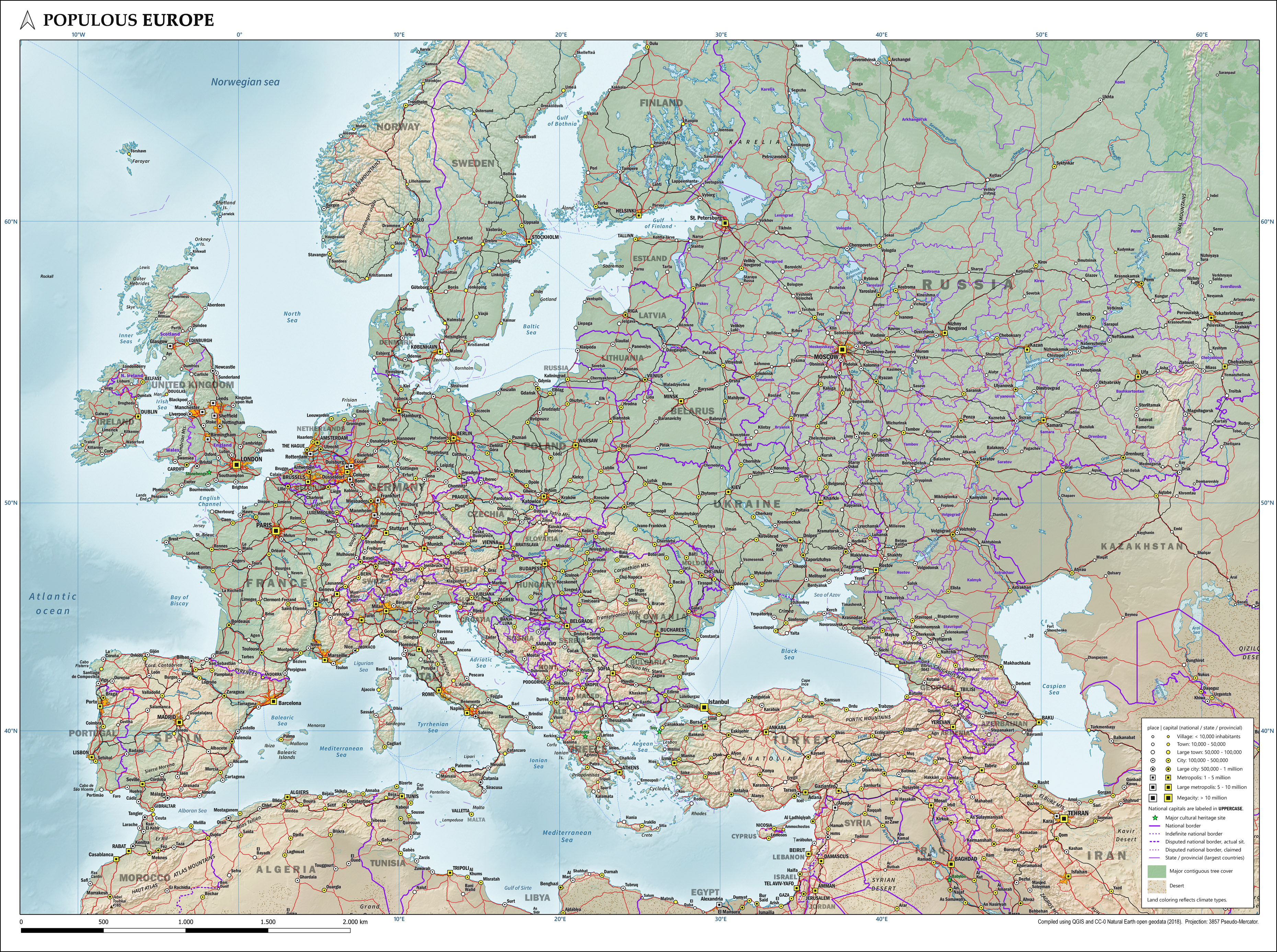
English: Map of the most populous part of Europe, showing physical, political and population characteristics, in Mercator projection, with legend, as per 2018. Compiled using QGIS and CC-0 Natural Earth geodata. |
| ତାରିଖ | |
| ମୂଳାଧାର | ଆପଣା କାମ |
| ଲେଖକ | Janwillemvanaalst |
ସତ୍ଵ
ମୁଁ, ଏହି କାମର ସତ୍ଵାଧିକାରୀ, ଏଠାରେ ତଳଲିଖିତ ଲାଇସେନ୍ସ ଅଧୀନରେ ଏହାକୁ ପ୍ରକାଶ କଲି:
This file is licensed under the Creative Commons Attribution 4.0 International license.
- ଆପଣ ଆରାମରେ:
- ବାଣ୍ଟିପାରିବେ – କାମଟିକୁ ନକଲ କରିପାରିବେ, ବାଣ୍ଟିପାରିବେ ଓ ପ୍ରସାରଣ କରିପାରିବେ
- ମିଶାଇପାରିବେ – କାମଟି ଅଭିଯୋଜନ କରିପାରିବେ
- ତଳଲିଖିତ ସର୍ତ୍ତାବଳୀ ଅଧୀନରେ:
- ଶ୍ରେୟ – ଆପଣ ମନେ କରି ଏହି କାମର ଆବଶ୍ୟକୀୟ ଶ୍ରେୟ ମୂଳ ଗଢ଼ାଳି ବା ସ୍ୱତ୍ୱାଧୀକାରୀଙ୍କୁ ଦେବେ ଏବଂ ଦେଲାବେଳେ ଲାଇସେନ୍ସର ଲିଙ୍କ ଦେଇ କି କି ବଦଳ କଲେ ଉଲ୍ଲେଖ କରିବେ । ଏହା ଉପଯୁକ୍ତ ଢଙ୍ଗରେ କରିବେ କିନ୍ତୁ ଲାଇସେନ୍ସ ଦେଉଥିବା ବ୍ୟକ୍ତି ଆପଣଙ୍କ ପ୍ରଚାର କଲା ଭଳି କିଛି ଲେଖିବେ ନାହିଁ ।
ଫାଇଲ ଇତିହାସ
ଏହା ଫାଇଲଟି ସେତେବେଳେ ଯେମିତି ଦିଶୁଥିଲା ତାହା ଦେଖିବା ପାଇଁ ତାରିଖ/ବେଳା ଉପରେ କ୍ଲିକ କରନ୍ତୁ
| ତାରିଖ/ବେଳ | ନଖ ଦେଖଣା | ଆକାର | ବ୍ୟବହାରକାରୀ | ମତାମତ | |
|---|---|---|---|---|---|
| ଏବେକାର | ୧୧:୧୪, ୧୯ ଅଗଷ୍ଟ ୨୦୨୦ | | ୩,୭୨୦ × ୨,୭୭୩ (୩.୭୬ MB) | Janwillemvanaalst | Uploaded own work with UploadWizard |
ଫାଇଲ ବ୍ୟବହାର
ଏହି ସବୁପୃଷ୍ଠା ଏହି ଫାଇଲଟିକୁ ଯୋଡ଼ିଥାନ୍ତି:
ଜଗତ ଫାଇଲ ବ୍ୟବହାର
ତଳଲିଖିତ ଉଇକିସବୁ ଏହି ଫାଇଲଟିକୁ ବ୍ୟବହାର କରିଥାନ୍ତି:
- en.wikipedia.orgରେ ବ୍ୟବହାର
- hy.wikipedia.orgରେ ବ୍ୟବହାର
- mnw.wikipedia.orgରେ ବ୍ୟବହାର
- zh.wikipedia.orgରେ ବ୍ୟବହାର
_with_legend.jpg)