
ଫାଇଲ:Map of Alabama NA.png

ଏହି ଦେଖଣାର ଆକାର: ୭୭୬ × ୬୦୦ ପିକ୍ସେଲ । ବାକି ରେଜୋଲୁସନ: ୩୧୧ × ୨୪୦ ପିକ୍ସେଲ | ୬୨୧ × ୪୮୦ ପିକ୍ସେଲ | ୯୯୪ × ୭୬୮ ପିକ୍ସେଲ | ୧,୨୮୦ × ୯୮୯ ପିକ୍ସେଲ | ୨,୧୨୨ × ୧,୬୪୦ ପିକ୍ସେଲ.
ମୂଳ ଫାଇଲ (୨,୧୨୨ × ୧,୬୪୦ ପିକସେଲ, ଫାଇଲ ଆକାର: ୧.୬୧ MB, ଏମ.ଆଇ.ଏମ.ଇର ପ୍ରକାର: image/png)
This is a file from the Wikimedia Commons. Information from its description page there is shown below. |
ସାରକଥା
| ବିବରଣୀ |
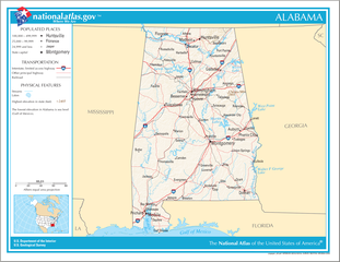
English: Map of the U.S. state of Alabama, with full legend area, copied from the National Atlas of the United States in high resolution form (1.61 megabytes). |
| ତାରିଖ | (uploaded on ୧୪ ଅଗଷ୍ଟ ୨୦୦୬) |
| ମୂଳାଧାର | |
| ଲେଖକ | National Atlas of the United States (uploaded by User:Huebi) |
| ଅନ୍ୟ ସଂସ୍କରଣ |
The map has some related variations:
|
ସତ୍ଵ
This map was obtained from an edition of the National Atlas of the United States. Like almost all works of the U.S. federal government, works from the National Atlas are in the public domain in the United States.
Online access: NationalAtlas.gov | 1970 print edition: Library of Congress, Perry-Castañeda Library
|
ଫାଇଲ ଇତିହାସ
ଏହା ଫାଇଲଟି ସେତେବେଳେ ଯେମିତି ଦିଶୁଥିଲା ତାହା ଦେଖିବା ପାଇଁ ତାରିଖ/ବେଳା ଉପରେ କ୍ଲିକ କରନ୍ତୁ
| ତାରିଖ/ବେଳ | ନଖ ଦେଖଣା | ଆକାର | ବ୍ୟବହାରକାରୀ | ମତାମତ | |
|---|---|---|---|---|---|
| ଏବେକାର | ୦୧:୩୮, ୧୫ ଅଗଷ୍ଟ ୨୦୦୬ | | ୨,୧୨୨ × ୧,୬୪୦ (୧.୬୧ MB) | Huebi~commonswiki | {{Information| |Description=Map of Alabama |Source=[http://www.nationalatlas.gov National Atlas] }} Category:Maps of the United States Category:Maps of Alabama {{PD-USGov-Atlas}} |
ଫାଇଲ ବ୍ୟବହାର
ଏହି ସବୁ4 ପୃଷ୍ଠାସବୁ ଏହି ଫାଇଲଟିକୁ ଯୋଡ଼ିଥାନ୍ତି:
ଜଗତ ଫାଇଲ ବ୍ୟବହାର
ତଳଲିଖିତ ଉଇକିସବୁ ଏହି ଫାଇଲଟିକୁ ବ୍ୟବହାର କରିଥାନ୍ତି:
- als.wikipedia.orgରେ ବ୍ୟବହାର
- bs.wikipedia.orgରେ ବ୍ୟବହାର
- ca.wikipedia.orgରେ ବ୍ୟବହାର
- de.wikipedia.orgରେ ବ୍ୟବହାର
- en.wikipedia.orgରେ ବ୍ୟବହାର
- hi.wikipedia.orgରେ ବ୍ୟବହାର
- hr.wiktionary.orgରେ ବ୍ୟବହାର
- hsb.wikipedia.orgରେ ବ୍ୟବହାର
- hu.wikipedia.orgରେ ବ୍ୟବହାର
- ilo.wikipedia.orgରେ ବ୍ୟବହାର
- it.wikipedia.orgରେ ବ୍ୟବହାର
- ja.wikipedia.orgରେ ବ୍ୟବହାର
- ko.wikipedia.orgରେ ବ୍ୟବହାର
- no.wikipedia.orgରେ ବ୍ୟବହାର
- simple.wikipedia.orgରେ ବ୍ୟବହାର
- si.wikipedia.orgରେ ବ୍ୟବହାର
- uz.wikipedia.orgରେ ବ୍ୟବହାର
- zea.wikipedia.orgରେ ବ୍ୟବହାର