
ଫାଇଲ:Liberec districts.png

ଏହି ଦେଖଣାର ଆକାର: ୭୭୭ × ୫୯୯ ପିକ୍ସେଲ । ବାକି ରେଜୋଲୁସନ: ୩୧୧ × ୨୪୦ ପିକ୍ସେଲ | ୬୨୨ × ୪୮୦ ପିକ୍ସେଲ | ୯୫୪ × ୭୩୬ ପିକ୍ସେଲ.
ମୂଳ ଫାଇଲ (୯୫୪ × ୭୩୬ ପିକସେଲ, ଫାଇଲ ଆକାର: ୧୬ KB, ଏମ.ଆଇ.ଏମ.ଇର ପ୍ରକାର: image/png)
This is a file from the Wikimedia Commons. Information from its description page there is shown below. |
ସାରକଥା
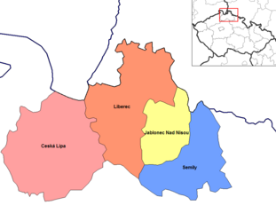
| ବିବରଣୀ | Map of the districts of Liberec region of the Czech Republic. Created by Rarelibra 15:12, 2 January 2007 (UTC) for public domain use, using MapInfo Professional v8.5 and various mapping resources. |
| ତାରିଖ | ୨ ଜାନୁଆରୀ ୨୦୦୭ (original upload date) |
| ମୂଳାଧାର | No machine-readable source provided. Own work assumed (based on copyright claims). |
| ଲେଖକ | No machine-readable author provided. Rarelibra assumed (based on copyright claims). |
ସତ୍ଵ
| ମୁଁ, ଏହି କାମର ସତ୍ଵାଧିକାରୀ, ଏହାକୁ ପବ୍ଲିକ ଡୋମେନରେ ଏହାକୁ ପ୍ରକାଶ କରୁଛି । ଏହା ଜଗତଯାକ ପାଇଁ ଲାଗୁ । କେତେକ ଦେଶରେ ଏହା ନ୍ୟାୟମତେ ଅନୁମୋଦିତ ହୋଇନପାରେ, ଯଦି ସେମିତି ହୁଏ: ମୁଁ, ଯେ ପର୍ଯ୍ୟନ୍ତ ଆଇନରେ କିଛି ସର୍ତ୍ତ ଦରକାର ନ ପଡ଼େ ସେ ପର୍ଯ୍ୟନ୍ତ ସଭିଙ୍କୁ କୌଣସି ବି ଉଦ୍ଦେଶ୍ୟରେ ଏହ କାମଟିକୁ ନିସର୍ତ୍ତ ବ୍ୟବହାର କରିବାକୁ ଅନୁମତି ଦେଉଛି । |
ଫାଇଲ ଇତିହାସ
ଏହା ଫାଇଲଟି ସେତେବେଳେ ଯେମିତି ଦିଶୁଥିଲା ତାହା ଦେଖିବା ପାଇଁ ତାରିଖ/ବେଳା ଉପରେ କ୍ଲିକ କରନ୍ତୁ
| ତାରିଖ/ବେଳ | ନଖ ଦେଖଣା | ଆକାର | ବ୍ୟବହାରକାରୀ | ମତାମତ | |
|---|---|---|---|---|---|
| ଏବେକାର | ୨୨:୨୯, ୫ ଜୁନ ୨୦୨୩ | | ୯୫୪ × ୭୩୬ (୧୬ KB) | Horecak | Cropped 10 % horizontally, 10 % vertically using CropTool with lossless mode. |
| ୨୦:୪୨, ୨ ଜାନୁଆରୀ ୨୦୦୭ |  | ୧,୦୫୬ × ୮୧୬ (୨୫ KB) | Rarelibra | Map of the districts of Liberec region of the Czech Republic. Created by ~~~~ for public domain use, using MapInfo Professional v8.5 and various mapping resources. |
ଫାଇଲ ବ୍ୟବହାର
ଏହି ସବୁପୃଷ୍ଠା ଏହି ଫାଇଲଟିକୁ ଯୋଡ଼ିଥାନ୍ତି:
ଜଗତ ଫାଇଲ ବ୍ୟବହାର
ତଳଲିଖିତ ଉଇକିସବୁ ଏହି ଫାଇଲଟିକୁ ବ୍ୟବହାର କରିଥାନ୍ତି:
- ar.wikipedia.orgରେ ବ୍ୟବହାର
- bg.wikipedia.orgରେ ବ୍ୟବହାର
- br.wikipedia.orgରେ ବ୍ୟବହାର
- bs.wikipedia.orgରେ ବ୍ୟବହାର
- ca.wikipedia.orgରେ ବ୍ୟବହାର
- ce.wikipedia.orgରେ ବ୍ୟବହାର
- cs.wikipedia.orgରେ ବ୍ୟବହାର
- da.wikipedia.orgରେ ବ୍ୟବହାର
- de.wikipedia.orgରେ ବ୍ୟବହାର
- de.wikivoyage.orgରେ ବ୍ୟବହାର
- en.wikipedia.orgରେ ବ୍ୟବହାର
- es.wikipedia.orgରେ ବ୍ୟବହାର
- fa.wikipedia.orgରେ ବ୍ୟବହାର
- frr.wikipedia.orgରେ ବ୍ୟବହାର
- fr.wikipedia.orgରେ ବ୍ୟବହାର
- hu.wikipedia.orgରେ ବ୍ୟବହାର
- hy.wikipedia.orgରେ ବ୍ୟବହାର
- it.wikipedia.orgରେ ବ୍ୟବହାର
- ka.wikipedia.orgରେ ବ୍ୟବହାର
- ko.wikipedia.orgରେ ବ୍ୟବହାର
- la.wikipedia.orgରେ ବ୍ୟବହାର
- lmo.wikipedia.orgରେ ବ୍ୟବହାର
- lt.wikipedia.orgରେ ବ୍ୟବହାର
- mk.wikipedia.orgରେ ବ୍ୟବହାର
- ms.wikipedia.orgରେ ବ୍ୟବହାର
- no.wikipedia.orgରେ ବ୍ୟବହାର
- pam.wikipedia.orgରେ ବ୍ୟବହାର
- pl.wikipedia.orgରେ ବ୍ୟବହାର
- pnb.wikipedia.orgରେ ବ୍ୟବହାର
- pt.wikipedia.orgରେ ବ୍ୟବହାର
- ro.wikipedia.orgରେ ବ୍ୟବହାର
- ru.wikipedia.orgରେ ବ୍ୟବହାର
- simple.wikipedia.orgରେ ବ୍ୟବହାର
- sl.wikipedia.orgରେ ବ୍ୟବହାର
ଏହି ଫାଇଲଟିର ଅଧିକ ବିଶ୍ୱବ୍ୟାପୀ ବ୍ୟବହାର ଦେଖନ୍ତୁ ।