
ଫାଇଲ:Invasions of the Roman Empire 1.png

ଏହି ଦେଖଣାର ଆକାର: ୮୦୦ × ୫୬୬ ପିକ୍ସେଲ । ବାକି ରେଜୋଲୁସନ: ୩୨୦ × ୨୨୬ ପିକ୍ସେଲ | ୬୪୦ × ୪୫୩ ପିକ୍ସେଲ | ୧,୦୨୪ × ୭୨୪ ପିକ୍ସେଲ | ୧,୨୮୦ × ୯୦୫ ପିକ୍ସେଲ | ୧,୯୫୪ × ୧,୩୮୨ ପିକ୍ସେଲ.
ମୂଳ ଫାଇଲ (୧,୯୫୪ × ୧,୩୮୨ ପିକସେଲ, ଫାଇଲ ଆକାର: ୨୬୯ KB, ଏମ.ଆଇ.ଏମ.ଇର ପ୍ରକାର: image/png)
This is a file from the Wikimedia Commons. Information from its description page there is shown below. |
ସାରକଥା
| ବିବରଣୀ |
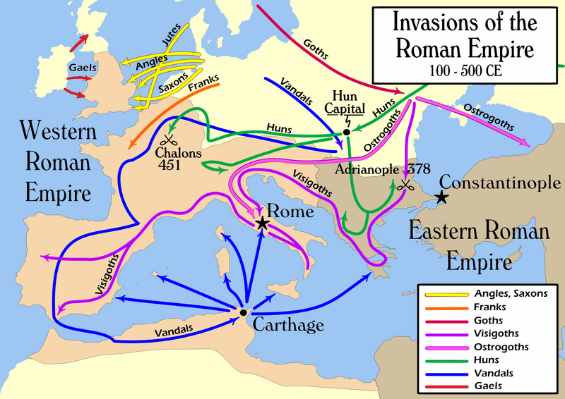
English: Map of the "barbarian" invasions by the Angles, Saxons, Jutes, Franks, Goths, Visigoths, Ostrogoths, Huns and Vandals of the Roman Empire showing the major incursions from 100 to 500 CE.
|
|||
| ତାରିଖ | ||||
| ମୂଳାଧାର | ଆପଣା କାମ | |||
| ଲେଖକ | User:MapMaster | |||
| ଅନ୍ୟ ସଂସ୍କରଣ |
[]
|


ସତ୍ଵ
ମୁଁ, ଏହି କାମର ସତ୍ଵାଧିକାରୀ, ଏଠାରେ ତଳଲିଖିତ ଲାଇସେନ୍ସ ଅଧୀନରେ ଏହାକୁ ପ୍ରକାଶ କଲି:
ଏହି ଫାଇଲଟି କ୍ରିଏଟିଭ କମନ୍ସ ଅଧୀନରେ ଆଟ୍ରିବୁସନ ସେଆର-ଏଲାଇକ ୨.୫ ଜେନେରିକ ଲାଇସେନ୍ସରେ ପଞ୍ଜିକରଣ କରାଯାଇଅଛି ।
- ଆପଣ ଆରାମରେ:
- ବାଣ୍ଟିପାରିବେ – କାମଟିକୁ ନକଲ କରିପାରିବେ, ବାଣ୍ଟିପାରିବେ ଓ ପ୍ରସାରଣ କରିପାରିବେ
- ମିଶାଇପାରିବେ – କାମଟି ଅଭିଯୋଜନ କରିପାରିବେ
- ତଳଲିଖିତ ସର୍ତ୍ତାବଳୀ ଅଧୀନରେ:
- ଶ୍ରେୟ – ଆପଣ ମନେ କରି ଏହି କାମର ଆବଶ୍ୟକୀୟ ଶ୍ରେୟ ମୂଳ ଗଢ଼ାଳି ବା ସ୍ୱତ୍ୱାଧୀକାରୀଙ୍କୁ ଦେବେ ଏବଂ ଦେଲାବେଳେ ଲାଇସେନ୍ସର ଲିଙ୍କ ଦେଇ କି କି ବଦଳ କଲେ ଉଲ୍ଲେଖ କରିବେ । ଏହା ଉପଯୁକ୍ତ ଢଙ୍ଗରେ କରିବେ କିନ୍ତୁ ଲାଇସେନ୍ସ ଦେଉଥିବା ବ୍ୟକ୍ତି ଆପଣଙ୍କ ପ୍ରଚାର କଲା ଭଳି କିଛି ଲେଖିବେ ନାହିଁ ।
- ସେଆର ଏଲାଇକ – ଯଦି ଆପଣ ଏହି କାମଟିକୁ ବଦଳାଇବେ, ରୂପାନ୍ତରଣ କରିବେ ବା ଏହାକୁ ନେଇ କିଛି ଗଢ଼ିବେ ତେବେ ଆପଣ ଏହାକୁ ଏକା ବା ଅଲଗା ଲାଇସେନ୍ସ ଭିତରେ ରଖିପାରିବେ ।
ଫାଇଲ ଇତିହାସ
ଏହା ଫାଇଲଟି ସେତେବେଳେ ଯେମିତି ଦିଶୁଥିଲା ତାହା ଦେଖିବା ପାଇଁ ତାରିଖ/ବେଳା ଉପରେ କ୍ଲିକ କରନ୍ତୁ
| ତାରିଖ/ବେଳ | ନଖ ଦେଖଣା | ଆକାର | ବ୍ୟବହାରକାରୀ | ମତାମତ | |
|---|---|---|---|---|---|
| ଏବେକାର | ୦୨:୩୮, ୧୫ ଫେବୃଆରୀ ୨୦୨୨ | | ୧,୯୫୪ × ୧,୩୮୨ (୨୬୯ KB) | SKIBLY101 | add the scotti |
| ୦୯:୦୬, ୯ ଜାନୁଆରୀ ୨୦୨୨ |  | ୧,୯୫୪ × ୧,୩୬୨ (୧୨୭ KB) | Jul059 | Lossless file size reduction | |
| ୨୧:୩୭, ୨୬ ଫେବୃଆରୀ ୨୦୧୪ |  | ୧,୯୫୪ × ୧,୩୬୨ (୧୩୯ KB) | Capmo | cropped very minor white margin | |
| ୧୪:୦୫, ୧୭ ଜୁଲାଇ ୨୦୦୭ |  | ୧,୯୬୨ × ୧,୩୭୪ (୧୩୯ KB) | Nihad Hamzic | Removed alpha channel, what enabled me to losslessly reduce color domain to 8-bit. The result is a much, much smaller file. If alpha channel is indeed needed, then just revert the actual image to the one which I had previously uploaded (around 480 KB). | |
| ୧୬:୧୮, ୧୬ ଜୁଲାଇ ୨୦୦୭ |  | ୧,୯୬୨ × ୧,୩୭୪ (୪୮୮ KB) | Nihad Hamzic | Further reduced image size by losslessly optimising PNG compression type. This image's color domain could be reduced to 8-bit if alpha channel was removed, resulting in enormous image size reducion. Is alpha channel really needed here? | |
| ୦୦:୫୭, ୧ ନଭେମ୍ବର ୨୦୦୬ |  | ୧,୯୬୨ × ୧,୩୭୪ (୬୨୪ KB) | MapMaster | Smaller, with some corrections and improvements | |
| ୨୦:୪୭, ୨୧ ଅକ୍ଟୋବର ୨୦୦୬ |  | ୧,୯୫୯ × ୧,୩୯୮ (୬୦୩ KB) | MapMaster | Improved version | |
| ୦୩:୦୫, ୨୦ ଅକ୍ଟୋବର ୨୦୦୬ |  | ୧,୯୬୧ × ୧,୪୦୫ (୬୦୨ KB) | MapMaster | I corrected the "Huns" route on this map, and am attempting to uploaded a 50% smaller version (Kbyte-wise). | |
| ୦୭:୦୫, ୨ ଅକ୍ଟୋବର ୨୦୦୬ |  | ୩,୯୪୮ × ୨,୮୨୭ (୧.୨୮ MB) | MapMaster | uploaded improved map | |
| ୨୩:୫୭, ୧ ଅକ୍ଟୋବର ୨୦୦୬ |  | ୩,୯୪୪ × ୨,୮୧୪ (୧.୦୪ MB) | MapMaster | Map of the "barbarian" invasions of the Roman Empire |
ଫାଇଲ ବ୍ୟବହାର
ଏହି ସବୁପୃଷ୍ଠା ଏହି ଫାଇଲଟିକୁ ଯୋଡ଼ିଥାନ୍ତି:
ଜଗତ ଫାଇଲ ବ୍ୟବହାର
ତଳଲିଖିତ ଉଇକିସବୁ ଏହି ଫାଇଲଟିକୁ ବ୍ୟବହାର କରିଥାନ୍ତି:
- ar.wikipedia.orgରେ ବ୍ୟବହାର
- azb.wikipedia.orgରେ ବ୍ୟବହାର
- az.wikipedia.orgରେ ବ୍ୟବହାର
- ba.wikipedia.orgରେ ବ୍ୟବହାର
- be-tarask.wikipedia.orgରେ ବ୍ୟବହାର
- be.wikipedia.orgରେ ବ୍ୟବହାର
- bg.wikipedia.orgରେ ବ୍ୟବହାର
- ckb.wikipedia.orgରେ ବ୍ୟବହାର
- csb.wikipedia.orgରେ ବ୍ୟବହାର
- cs.wikipedia.orgରେ ବ୍ୟବହାର
- da.wikipedia.orgରେ ବ୍ୟବହାର
- de.wikipedia.orgରେ ବ୍ୟବହାର
- de.wikibooks.orgରେ ବ୍ୟବହାର
- diq.wikipedia.orgରେ ବ୍ୟବହାର
- el.wikipedia.orgରେ ବ୍ୟବହାର
- en.wikipedia.orgରେ ବ୍ୟବହାର
- Civilization
- Germanic peoples
- History of Europe
- Ostrogoths
- Roman Empire
- History of Austria
- History of Bulgaria
- History of Tunisia
- Ancient history
- Migration Period
- Barbarian
- Seeress (Germanic)
- Western Roman Empire
- Ancient Rome
- Early Middle Ages
- Fall of the Western Roman Empire
- Talk:Attila/Archive 2
- Chernyakhov culture
- Roman Gaul
ଏହି ଫାଇଲଟିର ଅଧିକ ବିଶ୍ୱବ୍ୟାପୀ ବ୍ୟବହାର ଦେଖନ୍ତୁ ।