
ଫାଇଲ:Indus river.svg

Size of this PNG preview of this SVG file: ୫୫୫ × ୬୦୦ ପିକ୍ସେଲ. ବାକି ରେଜୋଲୁସନ: ୨୨୨ × ୨୪୦ ପିକ୍ସେଲ | ୪୪୪ × ୪୮୦ ପିକ୍ସେଲ | ୭୧୧ × ୭୬୮ ପିକ୍ସେଲ | ୯୪୮ × ୧,୦୨୪ ପିକ୍ସେଲ | ୧,୮୯୫ × ୨,୦୪୮ ପିକ୍ସେଲ | ୨,୩୦୯ × ୨,୪୯୫ ପିକ୍ସେଲ.
ମୂଳ ଫାଇଲ (SVG ଫାଇଲ, ସାଧାରଣ ମାପ ୨,୩୦୯ × ୨,୪୯୫ ପିକ୍ସେଲ, ଫାଇଲ ଆକାର: ୧୭୨ KB)
This is a file from the Wikimedia Commons. Information from its description page there is shown below. |
https://iasbaba.com/wp-content/uploads/2023/01/Indus-Waters-Treaty.png.webp
ସାରକଥା
| ବିବରଣୀ |
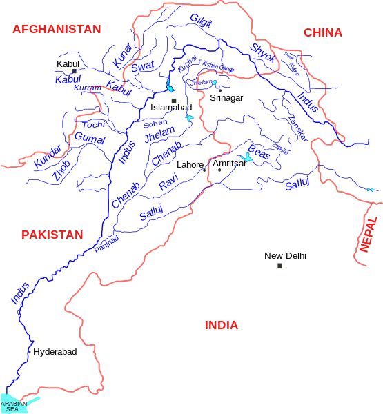
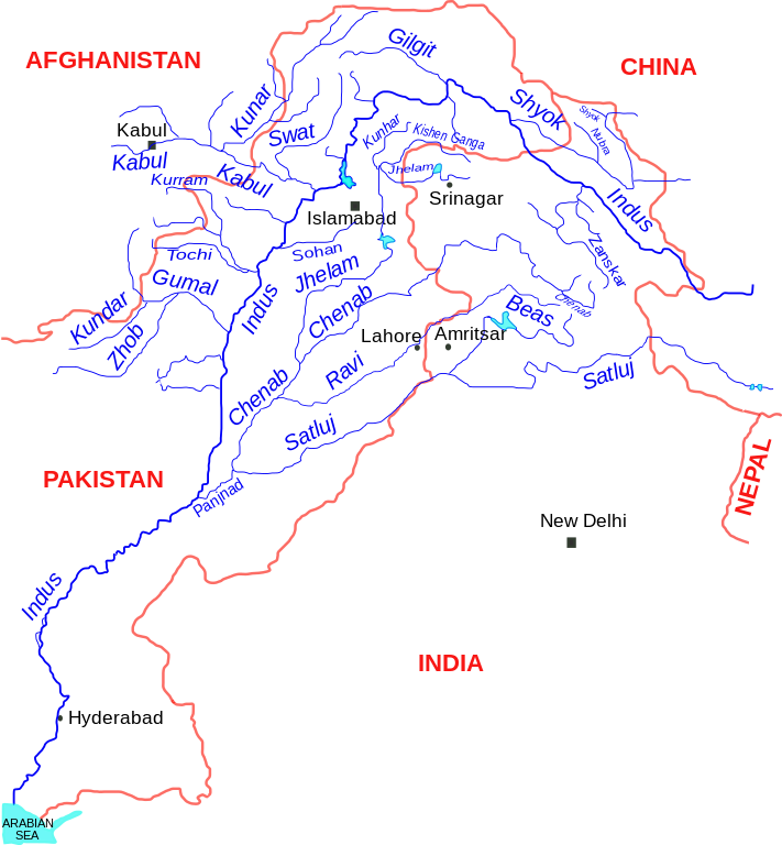
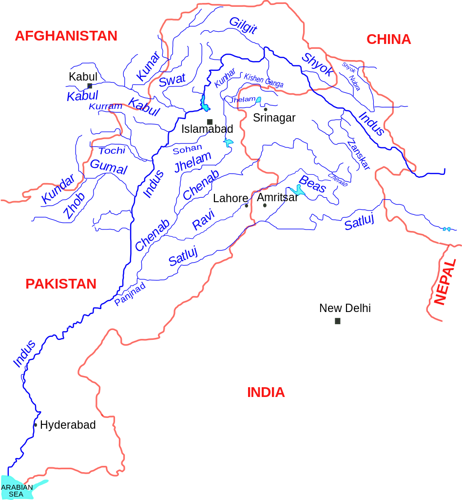
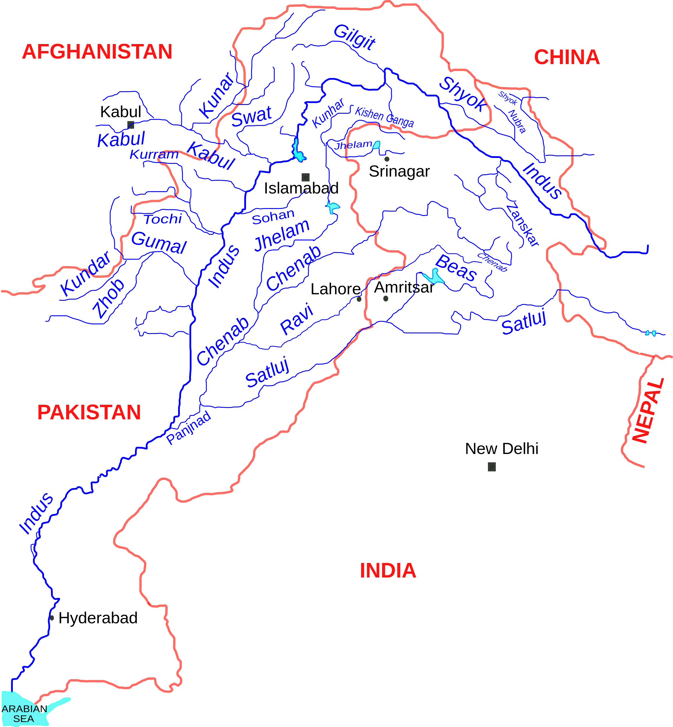
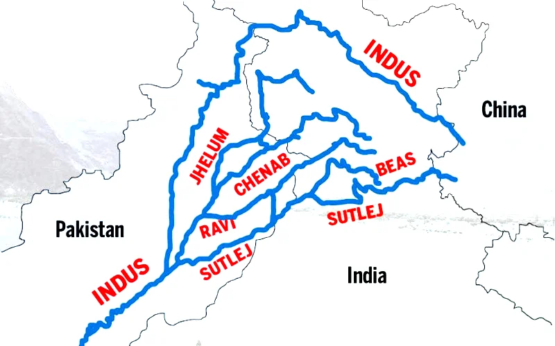
English: Indus river and tributaries, data based on The Times Atlas of the world (Family edition) |
| ତାରିଖ | |
| ମୂଳାଧାର | ଆପଣା କାମ |
| ଲେଖକ | Kmhkmh |
ସତ୍ଵ
ମୁଁ, ଏହି କାମର ସତ୍ଵାଧିକାରୀ, ଏଠାରେ ତଳଲିଖିତ ଲାଇସେନ୍ସ ଅଧୀନରେ ଏହାକୁ ପ୍ରକାଶ କଲି:
ଏହି ଫାଇଲଟି କ୍ରିଏଟିଭ କମନ୍ସ ଅଧୀନରେ ଆଟ୍ରିବୁସନ ୩.୦ ଜେନେରିକ ଲାଇସେନ୍ସରେ ପଞ୍ଜିକରଣ କରାଯାଇଅଛି ।
- ଆପଣ ଆରାମରେ:
- ବାଣ୍ଟିପାରିବେ – କାମଟିକୁ ନକଲ କରିପାରିବେ, ବାଣ୍ଟିପାରିବେ ଓ ପ୍ରସାରଣ କରିପାରିବେ
- ମିଶାଇପାରିବେ – କାମଟି ଅଭିଯୋଜନ କରିପାରିବେ
- ତଳଲିଖିତ ସର୍ତ୍ତାବଳୀ ଅଧୀନରେ:
- ଶ୍ରେୟ – ଆପଣ ମନେ କରି ଏହି କାମର ଆବଶ୍ୟକୀୟ ଶ୍ରେୟ ମୂଳ ଗଢ଼ାଳି ବା ସ୍ୱତ୍ୱାଧୀକାରୀଙ୍କୁ ଦେବେ ଏବଂ ଦେଲାବେଳେ ଲାଇସେନ୍ସର ଲିଙ୍କ ଦେଇ କି କି ବଦଳ କଲେ ଉଲ୍ଲେଖ କରିବେ । ଏହା ଉପଯୁକ୍ତ ଢଙ୍ଗରେ କରିବେ କିନ୍ତୁ ଲାଇସେନ୍ସ ଦେଉଥିବା ବ୍ୟକ୍ତି ଆପଣଙ୍କ ପ୍ରଚାର କଲା ଭଳି କିଛି ଲେଖିବେ ନାହିଁ ।
| Warning! According to Indian law, it is illegal to produce maps that in the view of the Indian government, misrepresent Indian territories by showing areas the Indian government claims ownership of but does not control as not belonging to India or as being contested. |
ଫାଇଲ ଇତିହାସ
ଏହା ଫାଇଲଟି ସେତେବେଳେ ଯେମିତି ଦିଶୁଥିଲା ତାହା ଦେଖିବା ପାଇଁ ତାରିଖ/ବେଳା ଉପରେ କ୍ଲିକ କରନ୍ତୁ
| ତାରିଖ/ବେଳ | ନଖ ଦେଖଣା | ଆକାର | ବ୍ୟବହାରକାରୀ | ମତାମତ | |
|---|---|---|---|---|---|
| ଏବେକାର | ୧୬:୪୯, ୧୧ ସେପ୍ଟେମ୍ବର ୨୦୧୭ | | ୨,୩୦୯ × ୨,୪୯୫ (୧୭୨ KB) | Kmhkmh | minor tweaks |
| ୦୧:୩୪, ୨୫ ଜୁଲାଇ ୨୦୧୫ |  | ୨,୩୦୯ × ୨,୪୯୫ (୧୭୩ KB) | Kmhkmh | the the modification is not correct and only depicting the _temporary_ flow of floodwaters | |
| ୨୩:୨୫, ୨୪ ଅପ୍ରେଲ ୨୦୧୫ |  | ୨,୩୦୯ × ୨,୪୯୫ (୧୮୨ KB) | RaviC | Rough redrawing of new southern pathway found. Source: http://indiatoday.intoday.in/story/indus-river-re-enters-india/1/158976.html | |
| ୧୫:୫୩, ୧ ଜୁନ ୨୦୦୯ |  | ୨,୩୦୯ × ୨,୪୯୫ (୧୭୩ KB) | Kmhkmh | few details added | |
| ୧୬:୦୨, ୩୦ ମଇ ୨୦୦୯ |  | ୨,୨୮୫ × ୨,୪୯୫ (୧୫୧ KB) | Kmhkmh | few detailes added | |
| ୦୩:୪୩, ୩୦ ମଇ ୨୦୦୯ |  | ୨,୨୮୫ × ୨,୪୯୫ (୧୨୧ KB) | Kmhkmh | {{Information |Description={{en|1=Indus river and tributaries}} |Source=Own work by uploader |Author=Kmhkmh |Date=2009-5-29 |Permission= |other_versions= }} <!--{{ImageUpload|full}}--> |
ଫାଇଲ ବ୍ୟବହାର
ଏହି ସବୁପୃଷ୍ଠା ଏହି ଫାଇଲଟିକୁ ଯୋଡ଼ିଥାନ୍ତି:
ଜଗତ ଫାଇଲ ବ୍ୟବହାର
ତଳଲିଖିତ ଉଇକିସବୁ ଏହି ଫାଇଲଟିକୁ ବ୍ୟବହାର କରିଥାନ୍ତି:
- af.wikipedia.orgରେ ବ୍ୟବହାର
- als.wikipedia.orgରେ ବ୍ୟବହାର
- am.wikipedia.orgରେ ବ୍ୟବହାର
- ar.wikipedia.orgରେ ବ୍ୟବହାର
- ast.wikipedia.orgରେ ବ୍ୟବହାର
- as.wikipedia.orgରେ ବ୍ୟବହାର
- awa.wikipedia.orgରେ ବ୍ୟବହାର
- azb.wikipedia.orgରେ ବ୍ୟବହାର
- ba.wikipedia.orgରେ ବ୍ୟବହାର
- be.wikipedia.orgରେ ବ୍ୟବହାର
- bg.wikipedia.orgରେ ବ୍ୟବହାର
- bh.wikipedia.orgରେ ବ୍ୟବହାର
- bn.wikipedia.orgରେ ବ୍ୟବହାର
- ca.wikipedia.orgରେ ବ୍ୟବହାର
- ceb.wikipedia.orgରେ ବ୍ୟବହାର
- ce.wikipedia.orgରେ ବ୍ୟବହାର
- ckb.wikipedia.orgରେ ବ୍ୟବହାର
- cs.wikipedia.orgରେ ବ୍ୟବହାର
- da.wikipedia.orgରେ ବ୍ୟବହାର
ଏହି ଫାଇଲଟିର ଅଧିକ ବିଶ୍ୱବ୍ୟାପୀ ବ୍ୟବହାର ଦେଖନ୍ତୁ ।