
ଫାଇଲ:Indus River - Envisat.jpg

ଏହି ଦେଖଣାର ଆକାର: ୬୩୦ × ୫୯୯ ପିକ୍ସେଲ । ବାକି ରେଜୋଲୁସନ: ୨୫୨ × ୨୪୦ ପିକ୍ସେଲ | ୫୦୫ × ୪୮୦ ପିକ୍ସେଲ | ୮୦୭ × ୭୬୮ ପିକ୍ସେଲ | ୧,୦୭୬ × ୧,୦୨୪ ପିକ୍ସେଲ | ୧,୪୪୦ × ୧,୩୭୦ ପିକ୍ସେଲ.
ମୂଳ ଫାଇଲ (୧,୪୪୦ × ୧,୩୭୦ ପିକସେଲ, ଫାଇଲ ଆକାର: ୧.୦୯ MB, ଏମ.ଆଇ.ଏମ.ଇର ପ୍ରକାର: image/jpeg)
This is a file from the Wikimedia Commons. Information from its description page there is shown below. |
ସାରକଥା
| Indus River | |
|---|---|
| ଚିତ୍ରୋତ୍ତଳକ |
Envisat satellite |
| ନାମ |
Indus River |
| ବିବରଣୀ |
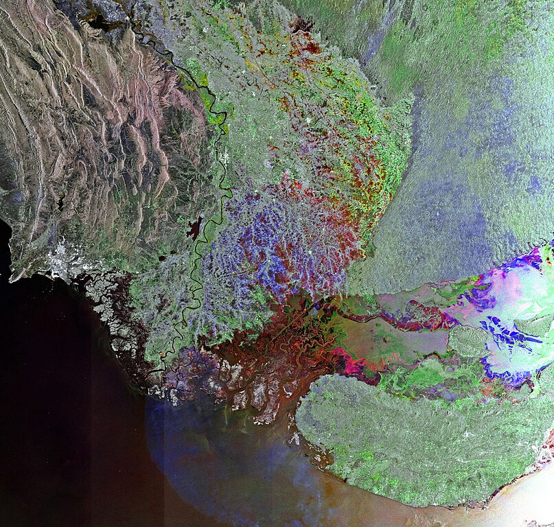
English: This Envisat image shows western India and southern Pakistan, with the Indus River snaking through Pakistan’s Sindh province before emptying into the Arabian Sea. The red area in the lower-central portion of the image covers a seasonal salt marsh over Pakistan’s border with western India.
This image is a compilation of three passes by Envisat’s radar on 15 May, 14 July and 12 September 2011. Each is assigned a colour (red, green and blue) and combined to produce this representation. The colours reveal changes in the surface between Envisat’s passes. |
| Depicted place | Indus River |
| ତାରିଖ | ୧୫ ମଇ ୨୦୧୧ - ୧୨ ସେପ୍ଟେମ୍ବର ୨୦୧୧ |
| Collection | European Space Agency |
| ଯୋଜନ ସଂଖ୍ୟା |
231287 |
| ଶ୍ରେୟ ଧାଡ଼ି | ESA |
| ମୂଳାଧାର | http://www.esa.int/spaceinimages/Images/2011/12/Indus_River |
ସତ୍ଵ
This file is licensed under the Creative Commons Attribution-ShareAlike 3.0 IGO license.
- ଆପଣ ଆରାମରେ:
- ବାଣ୍ଟିପାରିବେ – କାମଟିକୁ ନକଲ କରିପାରିବେ, ବାଣ୍ଟିପାରିବେ ଓ ପ୍ରସାରଣ କରିପାରିବେ
- ମିଶାଇପାରିବେ – କାମଟି ଅଭିଯୋଜନ କରିପାରିବେ
- ତଳଲିଖିତ ସର୍ତ୍ତାବଳୀ ଅଧୀନରେ:
- ଶ୍ରେୟ – ଆପଣ ମନେ କରି ଏହି କାମର ଆବଶ୍ୟକୀୟ ଶ୍ରେୟ ମୂଳ ଗଢ଼ାଳି ବା ସ୍ୱତ୍ୱାଧୀକାରୀଙ୍କୁ ଦେବେ ଏବଂ ଦେଲାବେଳେ ଲାଇସେନ୍ସର ଲିଙ୍କ ଦେଇ କି କି ବଦଳ କଲେ ଉଲ୍ଲେଖ କରିବେ । ଏହା ଉପଯୁକ୍ତ ଢଙ୍ଗରେ କରିବେ କିନ୍ତୁ ଲାଇସେନ୍ସ ଦେଉଥିବା ବ୍ୟକ୍ତି ଆପଣଙ୍କ ପ୍ରଚାର କଲା ଭଳି କିଛି ଲେଖିବେ ନାହିଁ ।
- ସେଆର ଏଲାଇକ – ଯଦି ଆପଣ ଏହି କାମଟିକୁ ବଦଳାଇବେ, ରୂପାନ୍ତରଣ କରିବେ ବା ଏହାକୁ ନେଇ କିଛି ଗଢ଼ିବେ ତେବେ ଆପଣ ଏହାକୁ ଏକା ବା ଅଲଗା ଲାଇସେନ୍ସ ଭିତରେ ରଖିପାରିବେ ।
ଫାଇଲ ଇତିହାସ
ଏହା ଫାଇଲଟି ସେତେବେଳେ ଯେମିତି ଦିଶୁଥିଲା ତାହା ଦେଖିବା ପାଇଁ ତାରିଖ/ବେଳା ଉପରେ କ୍ଲିକ କରନ୍ତୁ
| ତାରିଖ/ବେଳ | ନଖ ଦେଖଣା | ଆକାର | ବ୍ୟବହାରକାରୀ | ମତାମତ | |
|---|---|---|---|---|---|
| ଏବେକାର | ୧୦:୧୧, ୨୩ ଫେବୃଆରୀ ୨୦୧୭ | | ୧,୪୪୦ × ୧,୩୭୦ (୧.୦୯ MB) | Revent | =={{int:filedesc}}=={{Photograph |photographer = Envisat satellite |title = Indus River |description = {{en|This Envisat image shows western India and southern Pakistan, with the Indus River snaking through Pakistan’s Sin... |
ଫାଇଲ ବ୍ୟବହାର
ଏହି ସବୁପୃଷ୍ଠା ଏହି ଫାଇଲଟିକୁ ଯୋଡ଼ିଥାନ୍ତି:
ଜଗତ ଫାଇଲ ବ୍ୟବହାର
ତଳଲିଖିତ ଉଇକିସବୁ ଏହି ଫାଇଲଟିକୁ ବ୍ୟବହାର କରିଥାନ୍ତି:
- www.wikidata.orgରେ ବ୍ୟବହାର