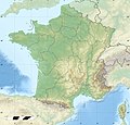
ଫାଇଲ:France relief location map.jpg

ଏହି ଦେଖଣାର ଆକାର: ୬୨୪ × ୬୦୦ ପିକ୍ସେଲ । ବାକି ରେଜୋଲୁସନ: ୨୫୦ × ୨୪୦ ପିକ୍ସେଲ | ୪୯୯ × ୪୮୦ ପିକ୍ସେଲ | ୭୯୯ × ୭୬୮ ପିକ୍ସେଲ | ୧,୦୬୬ × ୧,୦୨୪ ପିକ୍ସେଲ | ୨,୦୦୦ × ୧,୯୨୨ ପିକ୍ସେଲ.
ମୂଳ ଫାଇଲ (୨,୦୦୦ × ୧,୯୨୨ ପିକସେଲ, ଫାଇଲ ଆକାର: ୯୦୭ KB, ଏମ.ଆଇ.ଏମ.ଇର ପ୍ରକାର: image/jpeg)
ଫାଇଲ ଇତିହାସ
ଏହା ଫାଇଲଟି ସେତେବେଳେ ଯେମିତି ଦିଶୁଥିଲା ତାହା ଦେଖିବା ପାଇଁ ତାରିଖ/ବେଳା ଉପରେ କ୍ଲିକ କରନ୍ତୁ
| ତାରିଖ/ବେଳ | ନଖ ଦେଖଣା | ଆକାର | ବ୍ୟବହାରକାରୀ | ମତାମତ | |
|---|---|---|---|---|---|
| ଏବେକାର | ୨୦:୩୧, ୧୯ ଅକ୍ଟୋବର ୨୦୧୭ |  | ୨,୦୦୦ × ୧,୯୨୨ (୯୦୭ KB) | Sting | No borders over the Lake of Constance |
| ୧୪:୧୪, ୩ ଜାନୁଆରୀ ୨୦୧୬ |  | ୨,୦୦୦ × ୧,୯୨୨ (୮୮୮ KB) | Jack ma | updated new administrative region boundaries 1/1/2016 | |
| ୧୮:୦୧, ୨ ଅକ୍ଟୋବର ୨୦୧୨ |  | ୨,୦୦୦ × ୧,୯୨୨ (୮୧୪ KB) | Palosirkka | Reverted to version as of 22:20, 17 July 2010 Location maps must remain very accurate | |
| ୧୪:୪୪, ୨ ଅକ୍ଟୋବର ୨୦୧୨ |  | ୨,୦୦୦ × ୧,୯୨୨ (୭୯୭ KB) | Palosirkka | Optimized with http://trimage.org | |
| ୦୩:୫୦, ୧୮ ଜୁଲାଇ ୨୦୧୦ |  | ୨,୦୦୦ × ୧,୯୨୨ (୮୧୪ KB) | Sting | Color profile | |
| ୧୯:୪୫, ୧୭ ନଭେମ୍ବର ୨୦୦୯ |  | ୨,୦୦୦ × ୧,୯୨୨ (୮୨୨ KB) | Sting | Embedded sRGB profile | |
| ୧୮:୫୯, ୭ ନଭେମ୍ବର ୨୦୦୮ |  | ୨,୦୦୦ × ୧,୯୨୨ (୮୦୧ KB) | Sting | + boundary for Channel Islands ; - canals | |
| ୨୨:୧୧, ୨୩ ଅଗଷ୍ଟ ୨୦୦୮ |  | ୨,୦୦୦ × ୧,୯୨୨ (୮୦୩ KB) | Sting | Larger strokes for boundaries | |
| ୨୩:୨୮, ୨୫ ଜୁଲାଇ ୨୦୦୮ |  | ୨,୦୦୦ × ୧,୯୨୨ (୮୧୫ KB) | Sting | Variable scale | |
| ୨୦:୧୬, ୨୫ ଜୁଲାଇ ୨୦୦୮ |  | ୨,୦୦୦ × ୧,୯୨୨ (୮୧୪ KB) | Sting | - border |
ଫାଇଲ ବ୍ୟବହାର
ଏହି ସବୁପୃଷ୍ଠା ଏହି ଫାଇଲଟିକୁ ଯୋଡ଼ିଥାନ୍ତି:
ଜଗତ ଫାଇଲ ବ୍ୟବହାର
ତଳଲିଖିତ ଉଇକିସବୁ ଏହି ଫାଇଲଟିକୁ ବ୍ୟବହାର କରିଥାନ୍ତି:
- als.wikipedia.orgରେ ବ୍ୟବହାର
- Grosser Belchen
- Donon
- Vorlage:Positionskarte Frankreich
- Planche des Belles Filles
- Vorlage:Positionskarte Frankreich Haut-Rhin
- Vorlage:Positionskarte Frankreich Bas-Rhin
- Vorlage:Positionskarte Frankreich Saône-et-Loire
- Vorlage:Positionskarte Frankreich Paris
- Vorlage:Positionskarte Frankreich Territoire de Belfort
- Vorlage:Positionskarte Frankreich Essonne
- Vorlage:Positionskarte Frankreich Pyrénées-Orientales
- Vorlage:Positionskarte Frankreich Pas-de-Calais
- Vorlage:Positionskarte Frankreich Normandie
- Vorlage:Positionskarte Frankreich Orne
- Vorlage:Positionskarte Frankreich Île-de-France
- Vorlage:Positionskarte Frankreich Nord
- Vorlage:Positionskarte Frankreich Moselle
- Vorlage:Positionskarte Frankreich Morbihan
- Vorlage:Positionskarte Frankreich Maine-et-Loire
- Vorlage:Positionskarte Frankreich Pays de la Loire
- Vorlage:Positionskarte Frankreich Loire-Atlantique
- Vorlage:Positionskarte Frankreich Isère
- Vorlage:Positionskarte Frankreich Ille-et-Vilaine
- Vorlage:Positionskarte Frankreich Okzitanien
- Vorlage:Positionskarte Frankreich Gard
- Vorlage:Positionskarte Frankreich Korsika
- Vorlage:Positionskarte Frankreich Corse-du-Sud
- Vorlage:Positionskarte Frankreich Nouvelle-Aquitaine
- Vorlage:Positionskarte Frankreich Dordogne
- Vorlage:Positionskarte Frankreich Bretagne
- Vorlage:Positionskarte Frankreich Finistère
- Vorlage:Positionskarte Frankreich Côtes-d’Armor
- Vorlage:Positionskarte Frankreich Bourgogne-Franche-Comté
- Vorlage:Positionskarte Frankreich Alpes-Maritimes
- Vorlage:Positionskarte Frankreich Provence-Alpes-Côte d’Azur
- Vorlage:Positionskarte Frankreich Alpes-de-Haute-Provence
- Vorlage:Positionskarte Frankreich Allier
- Vorlage:Positionskarte Frankreich Hauts-de-France
- Vorlage:Positionskarte Frankreich Aisne
- Vorlage:Positionskarte Frankreich Auvergne-Rhône-Alpes
- Vorlage:Positionskarte Frankreich Ain
- Vorlage:Positionskarte Frankreich Grand Est
- Vorlage:Positionskarte Frankreich Ardèche
- Vorlage:Positionskarte Frankreich Calvados
- Vorlage:Positionskarte Frankreich Cantal
- Vorlage:Positionskarte Frankreich Charente
- Vorlage:Positionskarte Frankreich Centre-Val de Loire
- Vorlage:Positionskarte Frankreich Charente-Maritime
- Vorlage:Positionskarte Frankreich Haute-Corse
- Vorlage:Positionskarte Frankreich Eure
ଏହି ଫାଇଲଟିର ଅଧିକ ବିଶ୍ୱବ୍ୟାପୀ ବ୍ୟବହାର ଦେଖନ୍ତୁ ।


