
ଫାଇଲ:Bashar 1911.png
ମୂଳ ଫାଇଲ (୭୩୪ × ୬୦୪ ପିକସେଲ, ଫାଇଲ ଆକାର: ୧୯୮ KB, ଏମ.ଆଇ.ଏମ.ଇର ପ୍ରକାର: image/png)
This is a file from the Wikimedia Commons. Information from its description page there is shown below. |
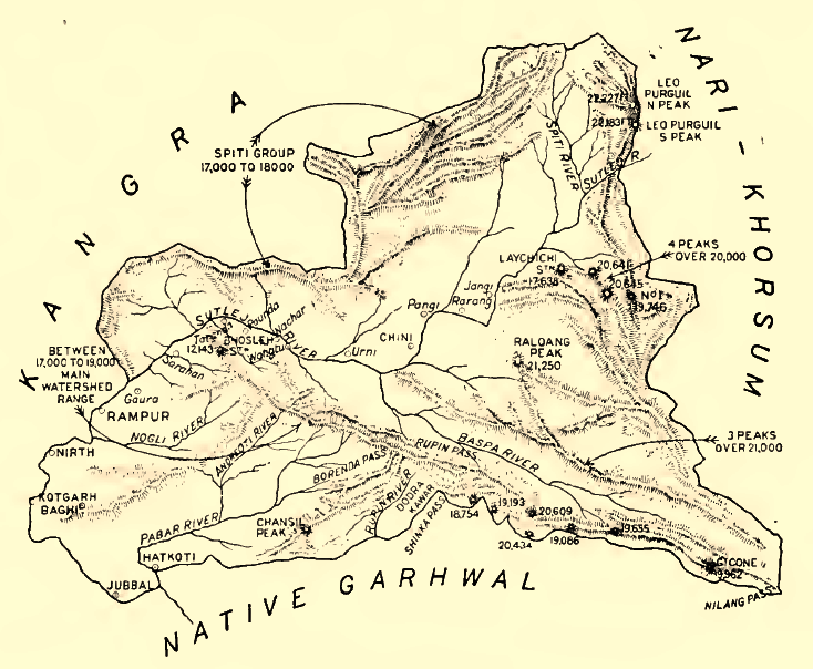
ସାରକଥା
| ବିବରଣୀ |
English: Sketch Map of the Indian Princely state of Bashar (Shimla Hills), 1911
Deutsch: Karte des indischen Fürstenstaates Bashar in den Shimla Hills, 1911. Höhenangaben in Fuß. |
| ତାରିଖ | |
| ମୂଳାଧାର | Provincial Geographies of India, Vol III |
| ଲେଖକ | Holland, Thomas H. (Thomas Henry), Sir |
ସତ୍ଵ
|
This work is in the public domain in its country of origin and other countries and areas where the copyright term is the author's life plus 70 years or fewer.
| |
| ଏହି ଫାଇଲଟିକୁ ସବୁ ସମ୍ଭନ୍ଧିତ ଓ ପାଖାପାଖି ନୀତି ଅନୁସାଅରେ ସତ୍ଵାଧିକାର ନୀତି ଅନୁସାରେ ସମସ୍ତ କଟକଣାରୁ କୋହଳ କରାଯାଇଛି । | |
ଫାଇଲ ଇତିହାସ
ଏହା ଫାଇଲଟି ସେତେବେଳେ ଯେମିତି ଦିଶୁଥିଲା ତାହା ଦେଖିବା ପାଇଁ ତାରିଖ/ବେଳା ଉପରେ କ୍ଲିକ କରନ୍ତୁ
| ତାରିଖ/ବେଳ | ନଖ ଦେଖଣା | ଆକାର | ବ୍ୟବହାରକାରୀ | ମତାମତ | |
|---|---|---|---|---|---|
| ଏବେକାର | ୧୩:୦୪, ୨୯ ଜୁନ ୨୦୧୪ | | ୭୩୪ × ୬୦୪ (୧୯୮ KB) | Xufanc | Sepia color |
| ୨୦:୫୨, ୧୮ ଜାନୁଆରୀ ୨୦୧୦ |  | ୭୩୪ × ୬୦୪ (୨୬୨ KB) | Zenwort | {{Information |Description={{en|1=Sketch Map of the Indian Princely state of Bashar (Shimla Hills), 1911}} {{de|1=Karte des indischen Fürstenstaates Bashar in den Shimla Hills, 1911. Höhenangaben in Fuß.}} |Source=Provincial Geographies of India, Vol I |
ଫାଇଲ ବ୍ୟବହାର
ଏହି ସବୁପୃଷ୍ଠା ଏହି ଫାଇଲଟିକୁ ଯୋଡ଼ିଥାନ୍ତି:
ଜଗତ ଫାଇଲ ବ୍ୟବହାର
ତଳଲିଖିତ ଉଇକିସବୁ ଏହି ଫାଇଲଟିକୁ ବ୍ୟବହାର କରିଥାନ୍ତି:
- de.wikipedia.orgରେ ବ୍ୟବହାର
- en.wikipedia.orgରେ ବ୍ୟବହାର
- ta.wikipedia.orgରେ ବ୍ୟବହାର