
ଫାଇଲ:ARG-2016-Aerial-Tierra del Fuego (Ushuaia)–Valle Carbajal 01.jpg

ଏହି ଦେଖଣାର ଆକାର: ୮୦୦ × ୫୩୪ ପିକ୍ସେଲ । ବାକି ରେଜୋଲୁସନ: ୩୨୦ × ୨୧୪ ପିକ୍ସେଲ | ୬୪୦ × ୪୨୮ ପିକ୍ସେଲ | ୧,୦୨୪ × ୬୮୪ ପିକ୍ସେଲ | ୧,୨୮୦ × ୮୫୫ ପିକ୍ସେଲ | ୨,୫୬୦ × ୧,୭୧୦ ପିକ୍ସେଲ | ୬,୩୩୫ × ୪,୨୩୨ ପିକ୍ସେଲ.
ମୂଳ ଫାଇଲ (୬,୩୩୫ × ୪,୨୩୨ ପିକସେଲ, ଫାଇଲ ଆକାର: ୧୯.୮୫ MB, ଏମ.ଆଇ.ଏମ.ଇର ପ୍ରକାର: image/jpeg)
This is a file from the Wikimedia Commons. Information from its description page there is shown below. |
|

%E2%80%93Valle_Carbajal_01.jpg)
%E2%80%93Valle_Carbajal_01.jpg)
%E2%80%93Valle_Carbajal_01.jpg)
%E2%80%93Valle_Carbajal_01.jpg)
ସାରକଥା
| ବିବରଣୀ |
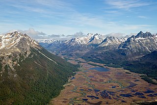
English: Aerial view of Valle Carbajal (terminus) in the Southern Andes, Tierra del Fuego Province, Argentina (Fuegian Andes within a 12 miles radius of Ushuaia) |
| ତାରିଖ | |
| ମୂଳାଧାର | ଆପଣା କାମ |
| ଲେଖକ | Godot13 |
| ଅନ୍ୟ ସଂସ୍କରଣ | |
| ଶ୍ରେୟ (required by the license) | Andrew Shiva / Wikipedia / |
| Camera location | | View this and other nearby images on: OpenStreetMap |
|---|
%E2%80%93Valle_Carbajal_01.jpg¶ms=-54.733952_N_-068.184233_E_globe:Earth_type:camera_heading:315.00&language=or)
ସତ୍ଵ
ମୁଁ, ଏହି କାମର ସତ୍ଵାଧିକାରୀ, ଏଠାରେ ତଳଲିଖିତ ଲାଇସେନ୍ସ ଅଧୀନରେ ଏହାକୁ ପ୍ରକାଶ କଲି:
This file is licensed under the Creative Commons Attribution-Share Alike 4.0 International license.
- ଆପଣ ଆରାମରେ:
- ବାଣ୍ଟିପାରିବେ – କାମଟିକୁ ନକଲ କରିପାରିବେ, ବାଣ୍ଟିପାରିବେ ଓ ପ୍ରସାରଣ କରିପାରିବେ
- ମିଶାଇପାରିବେ – କାମଟି ଅଭିଯୋଜନ କରିପାରିବେ
- ତଳଲିଖିତ ସର୍ତ୍ତାବଳୀ ଅଧୀନରେ:
- ଶ୍ରେୟ – ଆପଣ ମନେ କରି ଏହି କାମର ଆବଶ୍ୟକୀୟ ଶ୍ରେୟ ମୂଳ ଗଢ଼ାଳି ବା ସ୍ୱତ୍ୱାଧୀକାରୀଙ୍କୁ ଦେବେ ଏବଂ ଦେଲାବେଳେ ଲାଇସେନ୍ସର ଲିଙ୍କ ଦେଇ କି କି ବଦଳ କଲେ ଉଲ୍ଲେଖ କରିବେ । ଏହା ଉପଯୁକ୍ତ ଢଙ୍ଗରେ କରିବେ କିନ୍ତୁ ଲାଇସେନ୍ସ ଦେଉଥିବା ବ୍ୟକ୍ତି ଆପଣଙ୍କ ପ୍ରଚାର କଲା ଭଳି କିଛି ଲେଖିବେ ନାହିଁ ।
- ସେଆର ଏଲାଇକ – ଯଦି ଆପଣ ଏହି କାମଟିକୁ ବଦଳାଇବେ, ରୂପାନ୍ତରଣ କରିବେ ବା ଏହାକୁ ନେଇ କିଛି ଗଢ଼ିବେ ତେବେ ଆପଣ ଏହାକୁ ଏକା ବା ଅଲଗା ଲାଇସେନ୍ସ ଭିତରେ ରଖିପାରିବେ ।

|
ଉପଯୁକ୍ତ ଶ୍ରେୟ ଦିଆଯାଇଥିଲେ ଏହି ଫାଇଲର ସତ୍ଵାଧିକାରୀ, Andrew Shiva ସଭିଙ୍କୁ ଏହା କୌଣସି ବି କାମରେ ବ୍ୟବହାର କରିବା ନିମନ୍ତେ ଅନୁମତି ଦେଲେ । ପୁନବଣ୍ଟନ, ଆହରଣ, ବ୍ୟବସାୟିକ ବ୍ୟବହାର ଓ ବାକି ସବୁ ବ୍ୟବହାର ଅନୁମୋଦିତ ହୋଇଅଛି । |
ଶ୍ରେୟ:
Use or reproduction of this image outside of Wikipedia must give the original photographer (Andrew Shiva) credit. Although not required, it would be appreciated if a message was left here indicating where this image was being used.
|
ଫାଇଲ ଇତିହାସ
ଏହା ଫାଇଲଟି ସେତେବେଳେ ଯେମିତି ଦିଶୁଥିଲା ତାହା ଦେଖିବା ପାଇଁ ତାରିଖ/ବେଳା ଉପରେ କ୍ଲିକ କରନ୍ତୁ
| ତାରିଖ/ବେଳ | ନଖ ଦେଖଣା | ଆକାର | ବ୍ୟବହାରକାରୀ | ମତାମତ | |
|---|---|---|---|---|---|
| ଏବେକାର | ୧୭:୦୪, ୨୨ ଅଗଷ୍ଟ ୨୦୨୦ | | ୬,୩୩୫ × ୪,୨୩୨ (୧୯.୮୫ MB) | Fährtenleser | Optimizing contrasts, lights, balances |
| ୦୧:୩୭, ୮ ଫେବୃଆରୀ ୨୦୧୬ |  | ୬,୩୩୫ × ୪,୨୩୨ (୧୭.୨୨ MB) | Godot13 | User created page with UploadWizard |
ଫାଇଲ ବ୍ୟବହାର
ଏହି ସବୁପୃଷ୍ଠା ଏହି ଫାଇଲଟିକୁ ଯୋଡ଼ିଥାନ୍ତି:
ଜଗତ ଫାଇଲ ବ୍ୟବହାର
ତଳଲିଖିତ ଉଇକିସବୁ ଏହି ଫାଇଲଟିକୁ ବ୍ୟବହାର କରିଥାନ୍ତି:
- ar.wikipedia.orgରେ ବ୍ୟବହାର
- ay.wikipedia.orgରେ ବ୍ୟବହାର
- ceb.wikipedia.orgରେ ବ୍ୟବହାର
- cy.wikipedia.orgରେ ବ୍ୟବହାର
- de.wikipedia.orgରେ ବ୍ୟବହାର
- en.wikipedia.orgରେ ବ୍ୟବହାର
- Andes
- Bog
- Wikipedia:WikiProject Argentina
- Wikipedia:Featured pictures/Places/Landscapes
- Wikipedia:WikiProject Argentina/Recognized content
- Wikipedia:WikiProject Geology/Recognized content
- Peatland
- User talk:Godot13/Archive 4
- User:Godot13/Featured Pictures/Photographs
- Wikipedia:WikiProject Geology/Automated list of recognized content
- Wikipedia:Featured pictures thumbs/59
- Wikipedia:Featured picture candidates/February-2016
- Wikipedia:Recent additions/2016/February
- User:Godot13/Antarctica 2016
- Carbajal Valley
- Talk:Carbajal Valley
- Template:Did you know nominations/Carbajal Valley
- Wikipedia:Featured picture candidates/Carbajal Valley, Fuegian Andes (aerial)
- Wikipedia:Wikipedia Signpost/2016-02-24/Featured content
- Portal:Wetlands
- Portal:Wetlands/Did you know
- Wikipedia:Wikipedia Signpost/Single/2016-02-24
- Portal:Wetlands/Did you know/23
- User:Godot13/photographs/2016/Antarctica
- User:Amakuru/POTD 3
- Wikipedia:Picture of the day/January 2019
- Portal:Andes
- Template:POTD/2019-01-12
- Wikipedia:Main Page history/2019 January 12
- User:Gazamp/Safekeeping
- Wikipedia:Did you know/Statistics/Monthly DYK pageview leaders/2016/February
- es.wikipedia.orgରେ ବ୍ୟବହାର
- fa.wikipedia.orgରେ ବ୍ୟବହାର
- fr.wikipedia.orgରେ ବ୍ୟବହାର
- fy.wikipedia.orgରେ ବ୍ୟବହାର
- gl.wikipedia.orgରେ ବ୍ୟବହାର
%E2%80%93Valle_Carbajal_01.jpg)
%E2%80%93Valle_Carbajal_01.jpg)
ଏହି ଫାଇଲଟିର ଅଧିକ ବିଶ୍ୱବ୍ୟାପୀ ବ୍ୟବହାର ଦେଖନ୍ତୁ ।
%E2%80%93Valle_Carbajal_01.jpg)
–Valle_Carbajal_01.jpg)