
ଫାଇଲ:Punjab in India.png
Punjab_in_India.png (୩୫୦ × ୪୨୬ ପିକସେଲ, ଫାଇଲ ଆକାର: ୭୬ KB, ଏମ.ଆଇ.ଏମ.ଇର ପ୍ରକାର: image/png)
This is a file from the Wikimedia Commons. Information from its description page there is shown below. |
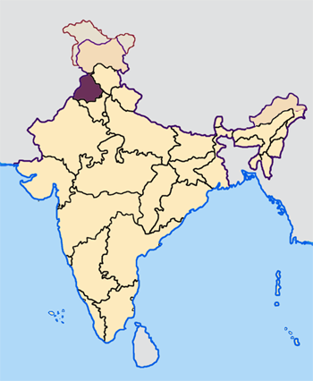
Map made by me, Nichalp
Note: The Indian state of w:Jammu and Kashmir is claimed by w:India, w:Pakistan and the w:People's Republic of China. This map depicts the boundaries of the state as it was in 1947. Areas administered by India is coloured as per the rest of the states, and the area administered by Pakistan and China are coloured in a neutral colour. See the map of Jammu and Kashmir.
The Indian state of w:Arunachal Pradesh is claimed by China as a part of w:South Tibet. The claimed region is depicted in a pale shade of pink. See the map of Arunachal Pradesh.
The Indian territorial waters extend to a distance of twelve nautical miles.

|
ମାଗଣା ସଫ୍ଟବେର ଫାଉଣ୍ଡେସନ ଦେଇ ପ୍ରକାଶିତ କୌଣସି ବଦଳାଇ ନହେବା ଭଳି ଧାରା, ଆଗ ବା ପଛ ପଟ ମଲାଟ ବିନା GNU ଖୋଲା ଦଲିଲକାରଣ ଲାଇସେନ୍ସ ୧.୨ ତମ ସଙ୍କଳନ ବା ଆଉ କୌଣସି ସର୍ତ୍ତାବଳି ଅନୁସାରେ ଏହି ଦଲିଲର ନକଲ, ବଣ୍ଟନ ତଥା/କିମ୍ବା ବଦଳାଇବା ନିମନ୍ତେ ଅନୁମତି ଦିଆଗଲା । GNU ମାଗଣା ଦଲିଲକରଣ ଲାଇସେନ୍ସ ନାମକ ବିଭାଗରେ ଲାଇସେନ୍ସର ନକଲ ଦିଆଯାଇଅଛି । |
| ଏହି ଫାଇଲଟି କ୍ରିଏଟିଭ କମନ୍ସ ଅଧୀନରେ ଆଟ୍ରିବୁସନ ସେଆର-ଏଲାଇକ ୩.୦ ଅନପୋର୍ଟେଡ଼ ଲାଇସେନ୍ସରେ ପଞ୍ଜିକରଣ କରାଯାଇଅଛି । | ||
| ||
| GFDL ଲାଇସେନ୍ସ ଅପଡେଟର ଏକ ଭାଗ ଭାବରେ ଏହି ଲାଇସେନ୍ସ ଚିହ୍ନଟି ଏହି ଫାଇଲରେ ଯୋଡ଼ା ଯାଇଥିଲା । |
ଫାଇଲ ଇତିହାସ
ଏହା ଫାଇଲଟି ସେତେବେଳେ ଯେମିତି ଦିଶୁଥିଲା ତାହା ଦେଖିବା ପାଇଁ ତାରିଖ/ବେଳା ଉପରେ କ୍ଲିକ କରନ୍ତୁ
| ତାରିଖ/ବେଳ | ନଖ ଦେଖଣା | ଆକାର | ବ୍ୟବହାରକାରୀ | ମତାମତ | |
|---|---|---|---|---|---|
| ଏବେକାର | ୧୩:୦୩, ୨୩ ଅପ୍ରେଲ ୨୦୦୫ | | ୩୫୦ × ୪୨୬ (୭୬ KB) | Nichalp | NPOV map |
| ୧୨:୫୨, ୨୩ ଅପ୍ରେଲ ୨୦୦୫ |  | ୨୦୦ × ୨୩୧ (୨୨ KB) | Kerpal | Reverted to earlier revision | |
| ୧୧:୫୭, ୨୩ ଅପ୍ରେଲ ୨୦୦୫ |  | ୫୦୦ × ୬୦୮ (୧୨୧ KB) | Nichalp | Reverted to earlier revision | |
| ୧୦:୩୦, ୨୩ ଅପ୍ରେଲ ୨୦୦୫ |  | ୨୦୦ × ୨୩୧ (୨୨ KB) | Kerpal | Reverted to earlier revision | |
| ୧୦:୨୪, ୨୩ ଅପ୍ରେଲ ୨୦୦୫ |  | ୫୦୦ × ୬୦୮ (୧୨୧ KB) | Nichalp | Reverted to earlier revision | |
| ୦୨:୩୬, ୨୩ ଅପ୍ରେଲ ୨୦୦୫ |  | ୨୦୦ × ୨୩୧ (୨୨ KB) | Kerpal | Reverted to earlier revision | |
| ୧୯:୦୮, ୨୨ ଅପ୍ରେଲ ୨୦୦୫ |  | ୫୦୦ × ୬୦୮ (୧୨୧ KB) | Nichalp | Reverted to earlier revision | |
| ୧୫:୧୩, ୨୨ ଅପ୍ରେଲ ୨୦୦୫ |  | ୨୦୦ × ୨୩୧ (୨୨ KB) | Kerpal | originally by en:User:Morwen | |
| ୨୩:୩୬, ୨୧ ଅପ୍ରେଲ ୨୦୦୫ |  | ୫୦୦ × ୬୦୮ (୧୨୧ KB) | Nichalp | ---- Map made by me, ~~~ ---- Note: The Indian state of w:Jammu and Kashmir is claimed by w:India, w:Pakistan and the w:People's Republic of China. This map depicts the boundaries of the state as it was in 1947. Areas administered by Indi |
ଫାଇଲ ବ୍ୟବହାର
ଏହି ସବୁ6 ପୃଷ୍ଠାସବୁ ଏହି ଫାଇଲଟିକୁ ଯୋଡ଼ିଥାନ୍ତି:
ଜଗତ ଫାଇଲ ବ୍ୟବହାର
ତଳଲିଖିତ ଉଇକିସବୁ ଏହି ଫାଇଲଟିକୁ ବ୍ୟବହାର କରିଥାନ୍ତି:
- awa.wikipedia.orgରେ ବ୍ୟବହାର
- bh.wikipedia.orgରେ ବ୍ୟବହାର
- अमृतसर जिला
- बरनाला जिला
- भटिंडा जिला
- फिरोजपुर जिला
- फरीदकोट जिला
- फतेहगढ़ साहिब जिला
- फजिल्का जिला
- गुरदासपुर जिला
- होशियारपुर जिला
- जालंधर जिला
- कपूरथला जिला
- लुधियाना जिला
- मानसा जिला
- मोगा जिला
- श्री मुक्तसर साहिब जिला
- पठानकोट जिला
- पटियाला जिला
- रूपनगर जिला
- संगरूर जिला
- शहीद भगत सिंह नगर जिला
- तरनतारन जिला
- टेम्पलेट:पंजाब
- bn.wikipedia.orgରେ ବ୍ୟବହାର
- bxr.wikipedia.orgରେ ବ୍ୟବହାର
- en.wikipedia.orgରେ ବ୍ୟବହାର
ଏହି ଫାଇଲଟିର ଅଧିକ ବିଶ୍ୱବ୍ୟାପୀ ବ୍ୟବହାର ଦେଖନ୍ତୁ ।