
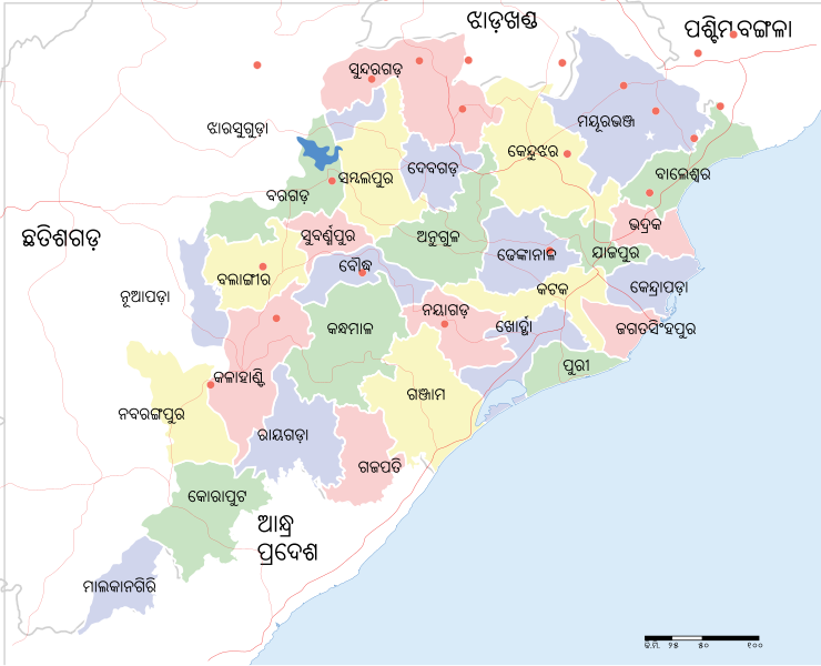
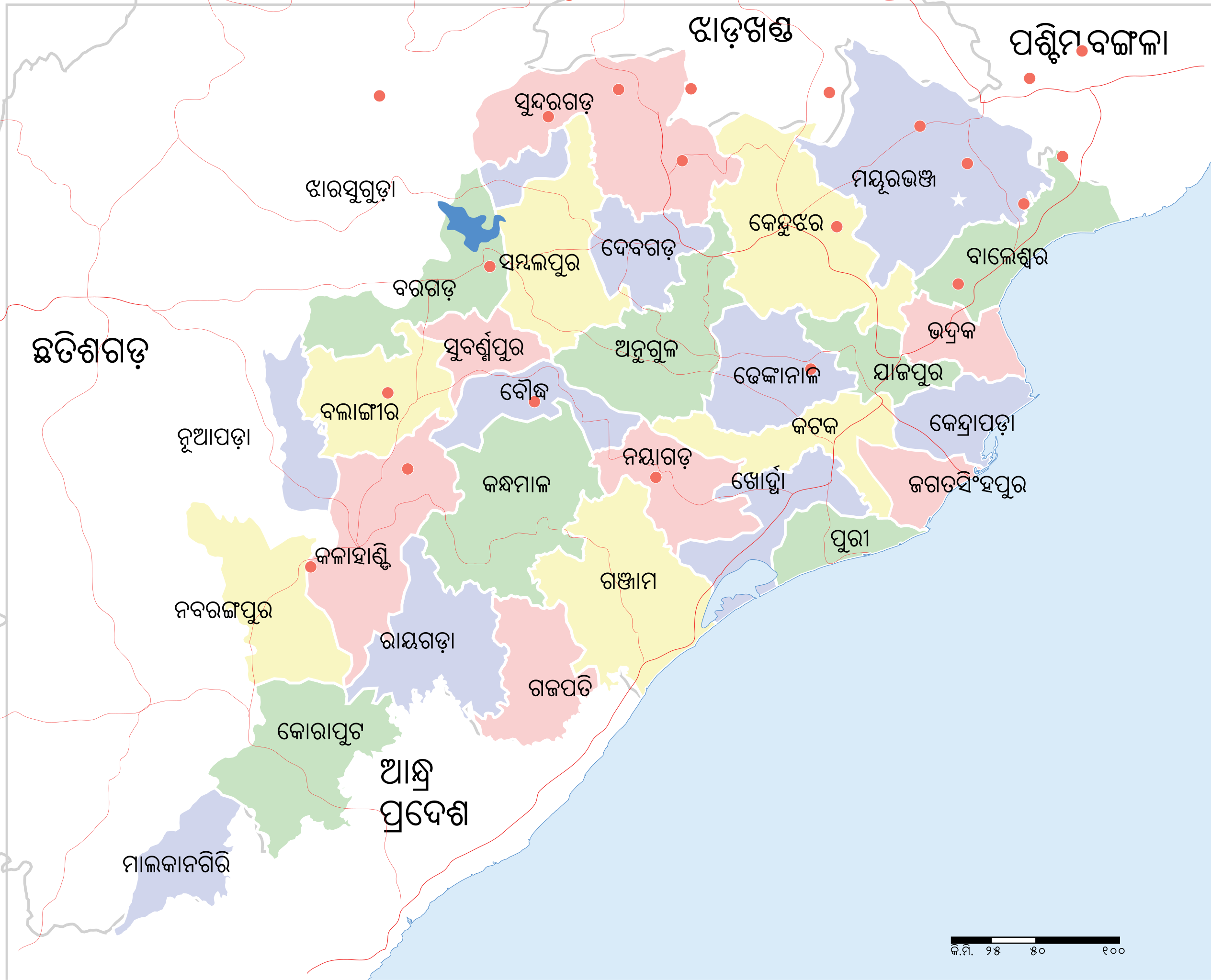
ଫାଇଲ:Odisha State map.svg

ମୂଳ ଫାଇଲ (SVG ଫାଇଲ, ସାଧାରଣ ମାପ ୨,୧୮୪ × ୧,୭୬୯ ପିକ୍ସେଲ, ଫାଇଲ ଆକାର: ୧.୭୬ MB)
This is a file from the Wikimedia Commons. Information from its description page there is shown below. |
| ଏହି ଛବିଟି ଓଡ଼ିଆ ଉଇକିପିଡ଼ିଆ ରେ ଅଗଷ୍ଟ ୨୨, ୨୦୧୧ ଦିନ ଦିନର ବଛା ଛବି ଭାବରେ ବ୍ୟବହାର କରାଇଥିଲା । |
ସାରକଥା
| ଶିରୋନାମ |
Odisha locator map |
||
| Description |
|
||
| ତାରିଖ | |||
| ମୂଳାଧାର |
ଆପଣା କାମ |
||
| Creator | |||
| ଅନୁମତି (ଏହି ଫାଇଲକୁ ପୁଣି ବ୍ୟବହାର କରିବେ) |
ମୁଁ, ଏହି କାମର ସତ୍ଵାଧିକାରୀ, ଏଠାରେ ତଳଲିଖିତ ଲାଇସେନ୍ସ ଅଧୀନରେ ଏହାକୁ ପ୍ରକାଶ କଲି: ଏହି ଫାଇଲଟି କ୍ରିଏଟିଭ କମନ୍ସ ଅଧୀନରେ ଆଟ୍ରିବୁସନ ସେଆର-ଏଲାଇକ ୩.୦ ଅନପୋର୍ଟେଡ଼ ଲାଇସେନ୍ସରେ ପଞ୍ଜିକରଣ କରାଯାଇଅଛି ।
|
||
| Geotemporal data | |||
| Date depicted | second half of 20 century ଓ 21 century | ||
| Georeferencing | If inappropriate please set warp_status = skip to hide. | ||
| Archival data | |||
| ଟୀକା | Part of WikiProject India Maps | ||
ସତ୍ଵ
- ଆପଣ ଆରାମରେ:
- ବାଣ୍ଟିପାରିବେ – କାମଟିକୁ ନକଲ କରିପାରିବେ, ବାଣ୍ଟିପାରିବେ ଓ ପ୍ରସାରଣ କରିପାରିବେ
- ମିଶାଇପାରିବେ – କାମଟି ଅଭିଯୋଜନ କରିପାରିବେ
- ତଳଲିଖିତ ସର୍ତ୍ତାବଳୀ ଅଧୀନରେ:
- ଶ୍ରେୟ – ଆପଣ ମନେ କରି ଏହି କାମର ଆବଶ୍ୟକୀୟ ଶ୍ରେୟ ମୂଳ ଗଢ଼ାଳି ବା ସ୍ୱତ୍ୱାଧୀକାରୀଙ୍କୁ ଦେବେ ଏବଂ ଦେଲାବେଳେ ଲାଇସେନ୍ସର ଲିଙ୍କ ଦେଇ କି କି ବଦଳ କଲେ ଉଲ୍ଲେଖ କରିବେ । ଏହା ଉପଯୁକ୍ତ ଢଙ୍ଗରେ କରିବେ କିନ୍ତୁ ଲାଇସେନ୍ସ ଦେଉଥିବା ବ୍ୟକ୍ତି ଆପଣଙ୍କ ପ୍ରଚାର କଲା ଭଳି କିଛି ଲେଖିବେ ନାହିଁ ।
- ସେଆର ଏଲାଇକ – ଯଦି ଆପଣ ଏହି କାମଟିକୁ ବଦଳାଇବେ, ରୂପାନ୍ତରଣ କରିବେ ବା ଏହାକୁ ନେଇ କିଛି ଗଢ଼ିବେ ତେବେ ଆପଣ ଏହାକୁ ଏକା ବା ଅଲଗା ଲାଇସେନ୍ସ ଭିତରେ ରଖିପାରିବେ ।
ଫାଇଲ ଇତିହାସ
ଏହା ଫାଇଲଟି ସେତେବେଳେ ଯେମିତି ଦିଶୁଥିଲା ତାହା ଦେଖିବା ପାଇଁ ତାରିଖ/ବେଳା ଉପରେ କ୍ଲିକ କରନ୍ତୁ
| ତାରିଖ/ବେଳ | ନଖ ଦେଖଣା | ଆକାର | ବ୍ୟବହାରକାରୀ | ମତାମତ | |
|---|---|---|---|---|---|
| ଏବେକାର | ୧୬:୫୨, ୧୮ ଅଗଷ୍ଟ ୨୦୧୧ | | ୨,୧୮୪ × ୧,୭୬୯ (୧.୭୬ MB) | Psubhashish |
ଫାଇଲ ବ୍ୟବହାର
ଏହି ସବୁ8 ପୃଷ୍ଠାସବୁ ଏହି ଫାଇଲଟିକୁ ଯୋଡ଼ିଥାନ୍ତି:
ଜଗତ ଫାଇଲ ବ୍ୟବହାର
ତଳଲିଖିତ ଉଇକିସବୁ ଏହି ଫାଇଲଟିକୁ ବ୍ୟବହାର କରିଥାନ୍ତି:
- ar.wikipedia.orgରେ ବ୍ୟବହାର
- en.wikipedia.orgରେ ବ୍ୟବହାର
- Wikipedia:WikiProject Odisha
- Odisha Day
- Wikipedia:WikiProject Odisha/Requested articles
- Wikipedia:WikiProject Odisha/Members
- Wikipedia:WikiProject Odisha/Featured and good content
- Wikipedia:Notice board for Orissa-related topics/It's new
- Wikipedia:WikiProject Odisha/Navigation
- Wikipedia:WikiProject Odisha/Assessment
- Wikipedia:WikiProject Odisha/Resources
- Wikipedia:WikiProject Odisha/Workgroups
- User:MKar/List/Chief Ministers of Odisha
- User:MKar/List/Districts of Odisha
- Wikipedia:Academy/Odisha
- ne.wikipedia.orgରେ ବ୍ୟବହାର
- new.wikipedia.orgରେ ବ୍ୟବହାର