ଫାଇଲ:NZL orthographic NaturalEarth.svg

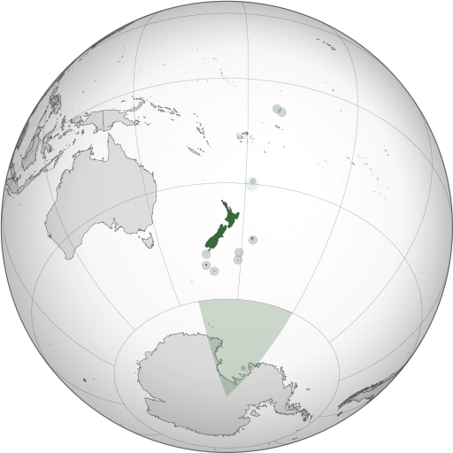
Size of this PNG preview of this SVG file: ୫୧୨ × ୫୧୨ ପିକ୍ସେଲ. ବାକି ରେଜୋଲୁସନ: ୨୪୦ × ୨୪୦ ପିକ୍ସେଲ | ୪୮୦ × ୪୮୦ ପିକ୍ସେଲ | ୭୬୮ × ୭୬୮ ପିକ୍ସେଲ | ୧,୦୨୪ × ୧,୦୨୪ ପିକ୍ସେଲ | ୨,୦୪୮ × ୨,୦୪୮ ପିକ୍ସେଲ.
ମୂଳ ଫାଇଲ (SVG ଫାଇଲ, ସାଧାରଣ ମାପ ୫୧୨ × ୫୧୨ ପିକ୍ସେଲ, ଫାଇଲ ଆକାର: ୫୭୪ KB)
ଫାଇଲ ଇତିହାସ
ଏହା ଫାଇଲଟି ସେତେବେଳେ ଯେମିତି ଦିଶୁଥିଲା ତାହା ଦେଖିବା ପାଇଁ ତାରିଖ/ବେଳା ଉପରେ କ୍ଲିକ କରନ୍ତୁ
| ତାରିଖ/ବେଳ | ନଖ ଦେଖଣା | ଆକାର | ବ୍ୟବହାରକାରୀ | ମତାମତ | |
|---|---|---|---|---|---|
| ଏବେକାର | ୦୩:୩୬, ୧ ନଭେମ୍ବର ୨୦୧୩ |  | ୫୧୨ × ୫୧୨ (୫୭୪ KB) | TooncesB | == Summary == {{Information |Description={{en|1=A map of the hemisphere centred on Wellington, New Zealand, using an orthographic projection, created using gringer's Perl script with [http://www.naturalear... |
| ୦୫:୨୨, ୬ ଅକ୍ଟୋବର ୨୦୧୩ |  | ୫୫୩ × ୫୫୩ (୫୦୫ KB) | TooncesB | {{Information |Description={{en|1=A map of the hemisphere centred on Wellington, New Zealand, using an orthographic projection, created using gringer's Perl script with [http://www.naturalearthdata.com/ Na... | |
| ୧୮:୫୨, ୨ ଅକ୍ଟୋବର ୨୦୧୩ |  | ୫୫୩ × ୫୫୩ (୫୦୪ KB) | TooncesB | {{Information |Description={{en|1=A map of the hemisphere centred on Wellington, New Zealand, using an orthographic projection, created using gringer's Perl script with [http://www.naturalearthdata.com/ Na... | |
| ୦୧:୩୭, ୨ ଅକ୍ଟୋବର ୨୦୧୩ |  | ୫୫୩ × ୫୫୩ (୫୫୬ KB) | TooncesB | {{Information |Description={{en|1=A map of the hemisphere centred on Wellington, New Zealand, using an orthographic projection, created using gringer's Perl script with [http://www.naturalearthdata.com/ Na... | |
| ୨୦:୧୧, ୧ ମଇ ୨୦୧୩ |  | ୫୫୩ × ୫୫୩ (୫୫୮ KB) | Gringer | Updated generation script (still needs some Inkscape hand-holding). Slightly larger image. Used high-resolution (10m) shapes for all countries, added highlight circles and Antarctica claim. | |
| ୧୦:୦୫, ୧ ସେପ୍ଟେମ୍ବର ୨୦୧୦ |  | ୫୫୦ × ୫୫୦ (୩୯୮ KB) | Gringer | Using high resolution (10m) shapes for New Zealand, removed odd Antarctica spike. | |
| ୦୪:୪୩, ୩୧ ଅଗଷ୍ଟ ୨୦୧୦ |  | ୫୫୦ × ୫୫୦ (୨୫୦ KB) | Gringer | changed size to fit with recommendations, white sea | |
| ୦୪:୨୪, ୩୧ ଅଗଷ୍ଟ ୨୦୧୦ |  | ୧,୦୫୦ × ୧,୦୫୦ (୨୪୯ KB) | Gringer | {{Information |Description={{en|1=A map of the hemisphere centred on Wellington, New Zealand, using an orthographic projection, created using gringer's [[[w:User:Gringer/perlshaper|Perl script] with [http://www.naturalearthdata.com/ Natur |
ଫାଇଲ ବ୍ୟବହାର
ଏହି ଫାଇଲ ସହିତ ଯୋଡ଼ା ଗୋଟିଏ ବି ପୃଷ୍ଠା ନାହିଁ ।
ଜଗତ ଫାଇଲ ବ୍ୟବହାର
ତଳଲିଖିତ ଉଇକିସବୁ ଏହି ଫାଇଲଟିକୁ ବ୍ୟବହାର କରିଥାନ୍ତି:
- ace.wikipedia.orgରେ ବ୍ୟବହାର
- ami.wikipedia.orgରେ ବ୍ୟବହାର
- ar.wikipedia.orgରେ ବ୍ୟବହାର
- as.wikipedia.orgରେ ବ୍ୟବହାର
- azb.wikipedia.orgରେ ବ୍ୟବହାର
- bg.wikipedia.orgରେ ବ୍ୟବହାର
- bh.wikipedia.orgରେ ବ୍ୟବହାର
- bn.wikipedia.orgରେ ବ୍ୟବହାର
- bs.wikipedia.orgରେ ବ୍ୟବହାର
- cdo.wikipedia.orgରେ ବ୍ୟବହାର
- ceb.wikipedia.orgରେ ବ୍ୟବହାର
- ckb.wikipedia.orgରେ ବ୍ୟବହାର
- cs.wikipedia.orgରେ ବ୍ୟବହାର
- da.wikipedia.orgରେ ବ୍ୟବହାର
- diq.wikipedia.orgରେ ବ୍ୟବହାର
- ee.wikipedia.orgରେ ବ୍ୟବହାର
- el.wikipedia.orgରେ ବ୍ୟବହାର
- en.wikipedia.orgରେ ବ୍ୟବହାର
- Portal:New Zealand
- User talk:Gringer
- New Zealand
- User:LJ Holden/dreams
- The Amazing Race 22
- User:J4kob123/sandbox
- User:Lbothwe/New Zealand
- User:Artemis Andromeda/sandbox/WikiBelta/Zealand Nuva
- Talk:List of guests at the state funeral of Elizabeth II
- Installations of the United States Navy in New Zealand
- en.wikibooks.orgରେ ବ୍ୟବହାର
- en.wiktionary.orgରେ ବ୍ୟବହାର
- es.wikipedia.orgରେ ବ୍ୟବହାର
- eu.wikipedia.orgରେ ବ୍ୟବହାର
- fa.wikipedia.orgରେ ବ୍ୟବହାର
- fi.wikipedia.orgରେ ବ୍ୟବହାର
- fj.wikipedia.orgରେ ବ୍ୟବହାର
- fr.wikipedia.orgରେ ବ୍ୟବହାର
- gl.wikipedia.orgରେ ବ୍ୟବହାର
- gn.wikipedia.orgରେ ବ୍ୟବହାର
- gu.wikipedia.orgରେ ବ୍ୟବହାର
- hak.wikipedia.orgରେ ବ୍ୟବହାର
- hif.wikipedia.orgରେ ବ୍ୟବହାର
- hi.wikipedia.orgରେ ବ୍ୟବହାର
- hr.wikipedia.orgରେ ବ୍ୟବହାର
ଏହି ଫାଇଲଟିର ଅଧିକ ବିଶ୍ୱବ୍ୟାପୀ ବ୍ୟବହାର ଦେଖନ୍ତୁ ।


