
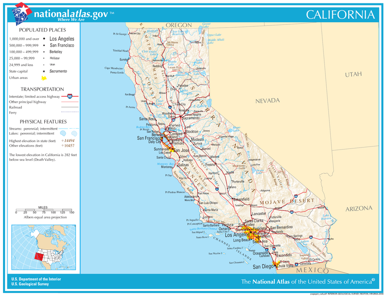
ଫାଇଲ:Map of California NA.png
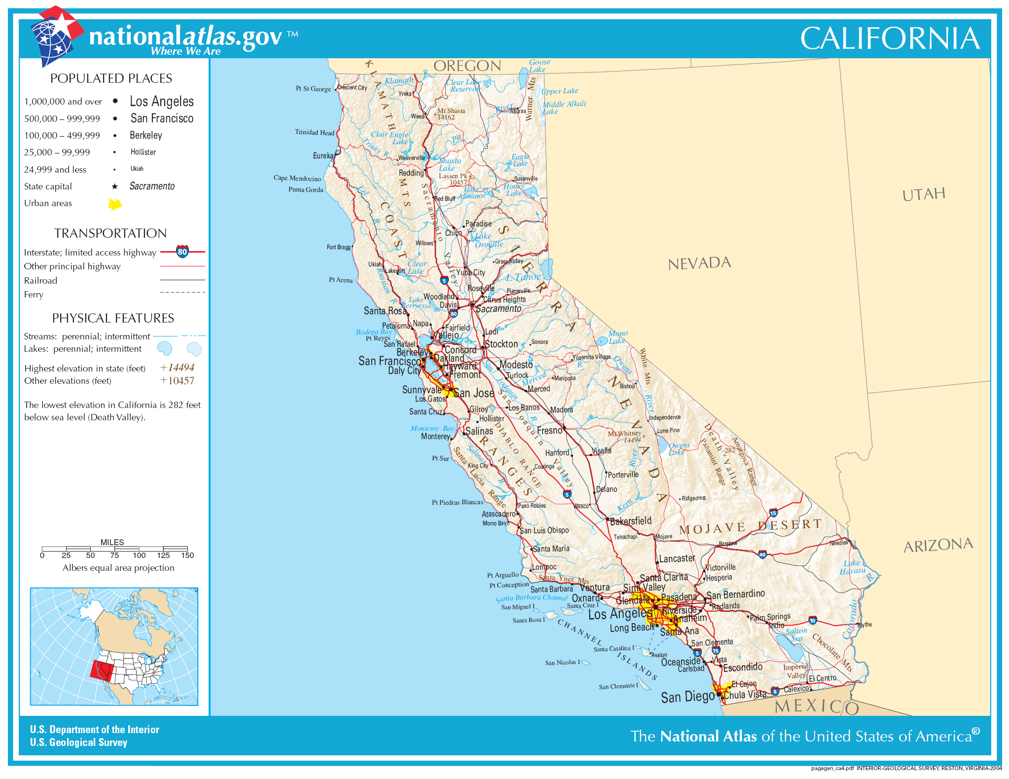
ଏହି ଦେଖଣାର ଆକାର: ୭୭୭ × ୬୦୦ ପିକ୍ସେଲ । ବାକି ରେଜୋଲୁସନ: ୩୧୧ × ୨୪୦ ପିକ୍ସେଲ | ୬୨୨ × ୪୮୦ ପିକ୍ସେଲ | ୯୯୫ × ୭୬୮ ପିକ୍ସେଲ | ୧,୨୮୦ × ୯୮୮ ପିକ୍ସେଲ | ୨,୦୪୬ × ୧,୫୭୯ ପିକ୍ସେଲ.
ମୂଳ ଫାଇଲ (୨,୦୪୬ × ୧,୫୭୯ ପିକସେଲ, ଫାଇଲ ଆକାର: ୧.୪୮ MB, ଏମ.ଆଇ.ଏମ.ଇର ପ୍ରକାର: image/png)
This is a file from the Wikimedia Commons. Information from its description page there is shown below. |
ସାରକଥା
| ବିବରଣୀ | |
| ତାରିଖ | |
| ମୂଳାଧାର | |
| ଲେଖକ | National Atlas of the United States |
| ଅନୁମତି (ଏହି ଫାଇଲକୁ ପୁଣି ବ୍ୟବହାର କରିବେ) |
Public domain |
ସତ୍ଵ
This map was obtained from an edition of the National Atlas of the United States. Like almost all works of the U.S. federal government, works from the National Atlas are in the public domain in the United States.
Online access: NationalAtlas.gov | 1970 print edition: Library of Congress, Perry-Castañeda Library
|
ଫାଇଲ ଇତିହାସ
ଏହା ଫାଇଲଟି ସେତେବେଳେ ଯେମିତି ଦିଶୁଥିଲା ତାହା ଦେଖିବା ପାଇଁ ତାରିଖ/ବେଳା ଉପରେ କ୍ଲିକ କରନ୍ତୁ
| ତାରିଖ/ବେଳ | ନଖ ଦେଖଣା | ଆକାର | ବ୍ୟବହାରକାରୀ | ମତାମତ | |
|---|---|---|---|---|---|
| ଏବେକାର | ୧୨:୦୪, ୩୦ ନଭେମ୍ବର ୨୦୦୬ | | ୨,୦୪୬ × ୧,୫୭୯ (୧.୪୮ MB) | Jengod | Crop to reduce excess whitespace on border |
| ୦୧:୪୯, ୧୫ ଅଗଷ୍ଟ ୨୦୦୬ |  | ୨,୧୨୨ × ୧,୬୪୦ (୧.୫୫ MB) | Huebi~commonswiki | {{Information| |Description=Map of Valifornia |Source=[http://www.nationalatlas.gov National Atlas] }} Category:Maps of the United States Category:Maps of California {{PD-USGov-Atlas}} |
ଫାଇଲ ବ୍ୟବହାର
ଏହି ସବୁ4 ପୃଷ୍ଠାସବୁ ଏହି ଫାଇଲଟିକୁ ଯୋଡ଼ିଥାନ୍ତି:
ଜଗତ ଫାଇଲ ବ୍ୟବହାର
ତଳଲିଖିତ ଉଇକିସବୁ ଏହି ଫାଇଲଟିକୁ ବ୍ୟବହାର କରିଥାନ୍ତି:
- als.wikipedia.orgରେ ବ୍ୟବହାର
- be-tarask.wikipedia.orgରେ ବ୍ୟବହାର
- bh.wikipedia.orgରେ ବ୍ୟବହାର
- ca.wikipedia.orgରେ ବ୍ୟବହାର
- de.wikipedia.orgରେ ବ୍ୟବହାର
- en.wikipedia.orgରେ ବ୍ୟବହାର
- eo.wikipedia.orgରେ ବ୍ୟବହାର
- fa.wikipedia.orgରେ ବ୍ୟବହାର
- fo.wikipedia.orgରେ ବ୍ୟବହାର
- hi.wikipedia.orgରେ ବ୍ୟବହାର
- hsb.wikipedia.orgରେ ବ୍ୟବହାର
- hu.wikipedia.orgରେ ବ୍ୟବହାର
- id.wikipedia.orgରେ ବ୍ୟବହାର
- ilo.wikipedia.orgରେ ବ୍ୟବହାର
- incubator.wikimedia.orgରେ ବ୍ୟବହାର
- it.wikipedia.orgରେ ବ୍ୟବହାର
- ja.wikipedia.orgରେ ବ୍ୟବହାର
ଏହି ଫାଇଲଟିର ଅଧିକ ବିଶ୍ୱବ୍ୟାପୀ ବ୍ୟବହାର ଦେଖନ୍ତୁ ।