
ଫାଇଲ:LocationSaintLucia.png
LocationSaintLucia.png (୨୫୦ × ୧୧୫ ପିକସେଲ, ଫାଇଲ ଆକାର: ୩ KB, ଏମ.ଆଇ.ଏମ.ଇର ପ୍ରକାର: image/png)
This is a file from the Wikimedia Commons. Information from its description page there is shown below. |
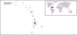
Location map for the Saint Lucia.
Originally created for English Wikipedia by Vardion.
| |
ଏହି କାମଟି ପବ୍ଲିକ ଡୋମେନ ରେ ଏହାର ଗଢ଼ାଳିVardion, at the ଇଂରାଜୀ ଉଇକିପିଡ଼ିଆ projectଙ୍କ ଦେଇ ପ୍ରକାଶିତ ହେଲା, ଏହା ଜଗତସାରା ଲାଗୁ । In case this is not legally possible: |

|
This locator map image could be re-created using vector graphics as an SVG file. This has several advantages; see Commons:Media for cleanup for more information. If an SVG form of this image is available, please upload it and afterwards replace this template with
{{vector version available|new image name}}.
It is recommended to name the SVG file “LocationSaintLucia.svg”—then the template Vector version available (or Vva) does not need the new image name parameter. |
ଫାଇଲ ଇତିହାସ
ଏହା ଫାଇଲଟି ସେତେବେଳେ ଯେମିତି ଦିଶୁଥିଲା ତାହା ଦେଖିବା ପାଇଁ ତାରିଖ/ବେଳା ଉପରେ କ୍ଲିକ କରନ୍ତୁ
| ତାରିଖ/ବେଳ | ନଖ ଦେଖଣା | ଆକାର | ବ୍ୟବହାରକାରୀ | ମତାମତ | |
|---|---|---|---|---|---|
| ଏବେକାର | ୨୩:୫୮, ୧୬ ଜାନୁଆରୀ ୨୦୦୮ | | ୨୫୦ × ୧୧୫ (୩ KB) | Mahahahaneapneap | pngcrushed |
| ୦୮:୩୩, ୨୦ ଡିସେମ୍ବର ୨୦୦୪ |  | ୨୫୦ × ୧୧୫ (୫ KB) | EugeneZelenko | Location map for the Saint Lucia.<br/>Originally created for English Wikipedia by Vardion.<br/>{{PD}}<br/>Category:Country locator maps |
ଫାଇଲ ବ୍ୟବହାର
ଏହି ଫାଇଲ ସହିତ ଯୋଡ଼ା ଗୋଟିଏ ବି ପୃଷ୍ଠା ନାହିଁ ।
ଜଗତ ଫାଇଲ ବ୍ୟବହାର
ତଳଲିଖିତ ଉଇକିସବୁ ଏହି ଫାଇଲଟିକୁ ବ୍ୟବହାର କରିଥାନ୍ତି:
- ar.wikipedia.orgରେ ବ୍ୟବହାର
- az.wiktionary.orgରେ ବ୍ୟବହାର
- ba.wikipedia.orgରେ ବ୍ୟବହାର
- be-tarask.wikipedia.orgରେ ବ୍ୟବହାର
- be.wikipedia.orgରେ ବ୍ୟବହାର
- bg.wikipedia.orgରେ ବ୍ୟବହାର
- bn.wikipedia.orgରେ ବ୍ୟବହାର
- bo.wikipedia.orgରେ ବ୍ୟବହାର
- bpy.wikipedia.orgରେ ବ୍ୟବହାର
- bs.wikipedia.orgରେ ବ୍ୟବହାର
- ca.wikipedia.orgରେ ବ୍ୟବହାର
- ceb.wikipedia.orgରେ ବ୍ୟବହାର
- ckb.wikipedia.orgରେ ବ୍ୟବହାର
- da.wikipedia.orgରେ ବ୍ୟବହାର
- de.wikivoyage.orgରେ ବ୍ୟବହାର
- de.wiktionary.orgରେ ବ୍ୟବହାର
- el.wiktionary.orgରେ ବ୍ୟବହାର
- en.wikipedia.orgରେ ବ୍ୟବହାର
- en.wikivoyage.orgରେ ବ୍ୟବହାର
- eo.wikipedia.orgରେ ବ୍ୟବହାର
- es.wikipedia.orgରେ ବ୍ୟବହାର
- es.wikinews.orgରେ ବ୍ୟବହାର
- ext.wikipedia.orgରେ ବ୍ୟବହାର
- fa.wikipedia.orgରେ ବ୍ୟବହାର
- fiu-vro.wikipedia.orgରେ ବ୍ୟବହାର
- fo.wikipedia.orgରେ ବ୍ୟବହାର
- frp.wikipedia.orgରେ ବ୍ୟବହାର
- fr.wikipedia.orgରେ ବ୍ୟବହାର
- fy.wikipedia.orgରେ ବ୍ୟବହାର
- gv.wikipedia.orgରେ ବ୍ୟବହାର
- he.wikivoyage.orgରେ ବ୍ୟବହାର
- hif.wikipedia.orgରେ ବ୍ୟବହାର
- hr.wikipedia.orgରେ ବ୍ୟବହାର
- ht.wikipedia.orgରେ ବ୍ୟବହାର
- hu.wikipedia.orgରେ ବ୍ୟବହାର
ଏହି ଫାଇଲଟିର ଅଧିକ ବିଶ୍ୱବ୍ୟାପୀ ବ୍ୟବହାର ଦେଖନ୍ତୁ ।