
ଫାଇଲ:India Karnataka location map.svg

Size of this PNG preview of this SVG file: ୪୨୩ × ୬୦୦ ପିକ୍ସେଲ. ବାକି ରେଜୋଲୁସନ: ୧୬୯ × ୨୪୦ ପିକ୍ସେଲ | ୩୩୮ × ୪୮୦ ପିକ୍ସେଲ | ୫୪୨ × ୭୬୮ ପିକ୍ସେଲ | ୭୨୨ × ୧,୦୨୪ ପିକ୍ସେଲ | ୧,୪୪୫ × ୨,୦୪୮ ପିକ୍ସେଲ | ୮୯୮ × ୧,୨୭୩ ପିକ୍ସେଲ.
ମୂଳ ଫାଇଲ (SVG ଫାଇଲ, ସାଧାରଣ ମାପ ୮୯୮ × ୧,୨୭୩ ପିକ୍ସେଲ, ଫାଇଲ ଆକାର: ୭୫୯ KB)
This is a file from the Wikimedia Commons. Information from its description page there is shown below. |
| ବିବରଣୀ |
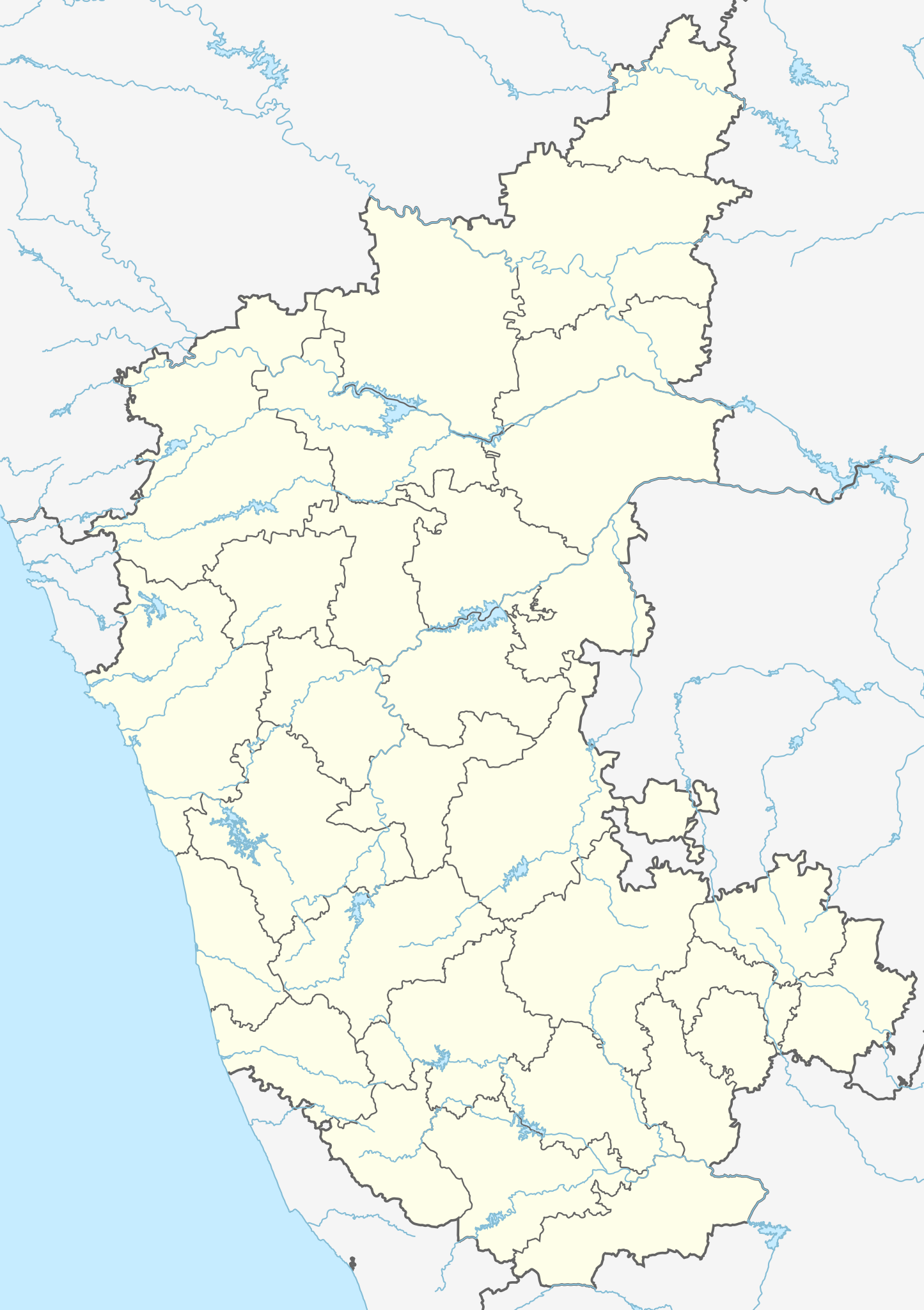
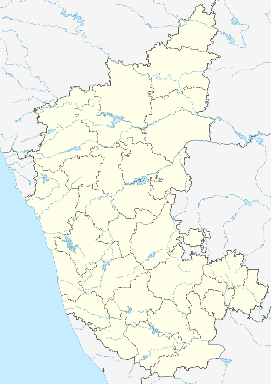
Location map of Karnataka Geographic limits of the map:
|
| ତାରିଖ | (UTC) |
| ମୂଳାଧାର | |
| ଲେଖକ |
|
| ଅନ୍ୟ ସଂସ୍କରଣ |
Derivative works of this file: |
| This is a retouched picture, which means that it has been digitally altered from its original version. Modifications: Created 3 new districts Chikkaballapur, Ramanagara and Yadgir. Changed conventions per WP:WPMAP. The original can be viewed here: Karnataka locator map.svg:
|
ଏହି ଫାଇଲଟି କ୍ରିଏଟିଭ କମନ୍ସ ଅଧୀନରେ ଆଟ୍ରିବୁସନ ସେଆର-ଏଲାଇକ ୩.୦ ଅନପୋର୍ଟେଡ଼ ଲାଇସେନ୍ସରେ ପଞ୍ଜିକରଣ କରାଯାଇଅଛି ।
- ଆପଣ ଆରାମରେ:
- ବାଣ୍ଟିପାରିବେ – କାମଟିକୁ ନକଲ କରିପାରିବେ, ବାଣ୍ଟିପାରିବେ ଓ ପ୍ରସାରଣ କରିପାରିବେ
- ମିଶାଇପାରିବେ – କାମଟି ଅଭିଯୋଜନ କରିପାରିବେ
- ତଳଲିଖିତ ସର୍ତ୍ତାବଳୀ ଅଧୀନରେ:
- ଶ୍ରେୟ – ଆପଣ ମନେ କରି ଏହି କାମର ଆବଶ୍ୟକୀୟ ଶ୍ରେୟ ମୂଳ ଗଢ଼ାଳି ବା ସ୍ୱତ୍ୱାଧୀକାରୀଙ୍କୁ ଦେବେ ଏବଂ ଦେଲାବେଳେ ଲାଇସେନ୍ସର ଲିଙ୍କ ଦେଇ କି କି ବଦଳ କଲେ ଉଲ୍ଲେଖ କରିବେ । ଏହା ଉପଯୁକ୍ତ ଢଙ୍ଗରେ କରିବେ କିନ୍ତୁ ଲାଇସେନ୍ସ ଦେଉଥିବା ବ୍ୟକ୍ତି ଆପଣଙ୍କ ପ୍ରଚାର କଲା ଭଳି କିଛି ଲେଖିବେ ନାହିଁ ।
- ସେଆର ଏଲାଇକ – ଯଦି ଆପଣ ଏହି କାମଟିକୁ ବଦଳାଇବେ, ରୂପାନ୍ତରଣ କରିବେ ବା ଏହାକୁ ନେଇ କିଛି ଗଢ଼ିବେ ତେବେ ଆପଣ ଏହାକୁ ଏକା ବା ଅଲଗା ଲାଇସେନ୍ସ ଭିତରେ ରଖିପାରିବେ ।
ମୂଲ ଅପଲୋଡ଼ ଫାଇଲ
This image is a derivative work of the following images:
- File:Karnataka_locator_map.svg licensed with Cc-by-sa-3.0
- 2007-05-06T13:55:02Z Planemad 1630x2356 (231773 Bytes) {{WikiProject_India_Maps |Title=Karnataka locator Map |Description=Map of [[w:Karnataka]] with road and rail lines |Source= [http://aquarium.lipetsk.ru/discovery/India2004/karnataka-map.jpg Karnataka Map], [http://www.indianr
Uploaded with derivativeFX
ଫାଇଲ ଇତିହାସ
ଏହା ଫାଇଲଟି ସେତେବେଳେ ଯେମିତି ଦିଶୁଥିଲା ତାହା ଦେଖିବା ପାଇଁ ତାରିଖ/ବେଳା ଉପରେ କ୍ଲିକ କରନ୍ତୁ
| ତାରିଖ/ବେଳ | ନଖ ଦେଖଣା | ଆକାର | ବ୍ୟବହାରକାରୀ | ମତାମତ | |
|---|---|---|---|---|---|
| ଏବେକାର | ୦୮:୪୦, ୧୬ ଜୁନ ୨୦୨୩ | | ୮୯୮ × ୧,୨୭୩ (୭୫୯ KB) | C1MM | c Vijayanagara district |
| ୧୦:୧୧, ୧୩ ଅଗଷ୍ଟ ୨୦୨୧ |  | ୮୫୧ × ୧,୨୧୧ (୫୮୨ KB) | C1MM | Added more rivers | |
| ୦୯:୦୩, ୧୬ ଜୁଲାଇ ୨୦୨୧ |  | ୮୫୧ × ୧,୨୧୧ (୫୬୧ KB) | C1MM | Added more accurate district boundaries | |
| ୦୫:୧୧, ୧୫ ଡିସେମ୍ବର ୨୦୨୦ |  | ୧,୬୩୪ × ୨,୩୬୭ (୩୪୧ KB) | C1MM | Fixed boundaries of Vijayanagara district | |
| ୦୩:୪୦, ୧୫ ଡିସେମ୍ବର ୨୦୨୦ |  | ୧,୬୩୪ × ୨,୩୬୭ (୩୪୫ KB) | C1MM | Added boundaries of AP/Telangana and rivers | |
| ୦୦:୫୬, ୧୪ ଡିସେମ୍ବର ୨୦୨୦ |  | ୧,୬୩୪ × ୨,୩୬୭ (୩୪୨ KB) | C1MM | Fixed district boundaries of Ballari and added Vijayanagara district | |
| ୦୯:୨୩, ୨୧ ଅପ୍ରେଲ ୨୦୨୦ |  | ୧,୬୩୪ × ୨,୩୬୭ (୨୮୯ KB) | C1MM | Added rivers | |
| ୨୧:୨୦, ୧୫ ନଭେମ୍ବର ୨୦୧୦ |  | ୧,୬୩୦ × ୨,୩୫୬ (୨୦୭ KB) | Nayvik | Changed background color | |
| ୨୧:୦୪, ୧୫ ନଭେମ୍ବର ୨୦୧୦ |  | ୧,୬୩୦ × ୨,୩୫୬ (୨୦୬ KB) | Nayvik | {{Information |Description=Location map of Karnataka Geographic limits of the map: * 18.5°N * 11.0°N * 73.6°E * 78.7°E |Source=*File:Karnataka_locator_map.svg, [http://www.censusindia.gov.in/2011-Images/ADMINI2011.jpg Census In |
ଫାଇଲ ବ୍ୟବହାର
ଏହି ସବୁ7 ପୃଷ୍ଠାସବୁ ଏହି ଫାଇଲଟିକୁ ଯୋଡ଼ିଥାନ୍ତି:
ଜଗତ ଫାଇଲ ବ୍ୟବହାର
ତଳଲିଖିତ ଉଇକିସବୁ ଏହି ଫାଇଲଟିକୁ ବ୍ୟବହାର କରିଥାନ୍ତି:
- ar.wikipedia.orgରେ ବ୍ୟବହାର
- as.wikipedia.orgରେ ବ୍ୟବହାର
- azb.wikipedia.orgରେ ବ୍ୟବହାର
- تومکور
- بنقلور
- عباسی، کارناتاکا
- اودقولام
- پیکلیهال
- اوداجی (هیندوستان)
- اوچیلا, اودوپی دیستریکت
- اوچاواد
- او خاناپور
- ویراهانوماکاناپالیا
- فاجیر (هیندوستان)
- پتالور (هیندوستان)
- پت آماپور
- ویراکامبا
- ویراپور
- وانور (هیندوستان)
- ساتیجری
- ساتانور, ماقادی
- ساتانور, بانقالور
- ساسالاتی
- سارقور
- ساراواد
- ساراپادی
- ساپتاساقار
- سانتور
- سانتکاسالاجر
- مایاکوندا
- ساناتی
- ماویناکر
- ماوالی
- ماتیواد
- کالادکا
- سانیکاتا
- کالکونت
- کالکری
- ماتماری
- سانقاناهالا
- کالجی (هیندوستان)
- سانقامشوارا, کالاقاتاجی
- ماتاداکوروباراهاتی
- ماستیهولی
- کالاسا, کوندقول
- ماسارکال
- ماسابینال
ଏହି ଫାଇଲଟିର ଅଧିକ ବିଶ୍ୱବ୍ୟାପୀ ବ୍ୟବହାର ଦେଖନ୍ତୁ ।