
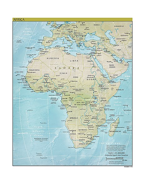
ଫାଇଲ:AfricaCIA-HiRes.jpg

ଏହି ଦେଖଣାର ଆକାର: ୪୬୩ × ୫୯୯ ପିକ୍ସେଲ । ବାକି ରେଜୋଲୁସନ: ୧୮୫ × ୨୪୦ ପିକ୍ସେଲ | ୩୭୧ × ୪୮୦ ପିକ୍ସେଲ | ୫୯୩ × ୭୬୮ ପିକ୍ସେଲ | ୭୯୧ × ୧,୦୨୪ ପିକ୍ସେଲ | ୧,୬୩୨ × ୨,୧୧୨ ପିକ୍ସେଲ.
ମୂଳ ଫାଇଲ (୧,୬୩୨ × ୨,୧୧୨ ପିକସେଲ, ଫାଇଲ ଆକାର: ୨.୦୧ MB, ଏମ.ଆଇ.ଏମ.ଇର ପ୍ରକାର: image/jpeg)
This is a file from the Wikimedia Commons. Information from its description page there is shown below. |
This image is in the public domain because it contains materials that originally came from the United States Central Intelligence Agency's World Factbook.
|
 |
http://www2.cia.gov/africa.zip archive copy at the Wayback Machine
Derivate version
Derivative works of this file: Map of Africa hr.pdf
ଫାଇଲ ଇତିହାସ
ଏହା ଫାଇଲଟି ସେତେବେଳେ ଯେମିତି ଦିଶୁଥିଲା ତାହା ଦେଖିବା ପାଇଁ ତାରିଖ/ବେଳା ଉପରେ କ୍ଲିକ କରନ୍ତୁ
| ତାରିଖ/ବେଳ | ନଖ ଦେଖଣା | ଆକାର | ବ୍ୟବହାରକାରୀ | ମତାମତ | |
|---|---|---|---|---|---|
| ଏବେକାର | ୦୯:୧୫, ୧ ଜୁନ ୨୦୨୦ | | ୧,୬୩୨ × ୨,୧୧୨ (୨.୦୧ MB) | Bestoernesto | added the newest map with Eswatini |
| ୦୦:୦୯, ୧୭ ଜୁଲାଇ ୨୦୧୧ |  | ୨,୧୦୮ × ୨,୬୪୨ (୮୫୪ KB) | Hoshie | added the newest map with South Sudan. Note this map has Kosovo and the colors have changed in recent years. | |
| ୦୦:୦୪, ୧୨ ଜୁନ ୨୦୦୫ |  | ୧,୨୧୮ × ୧,୫୦୦ (୩୩୦ KB) | Dubaduba~commonswiki | {{PD-USGov-CIA-WF}} http://www2.cia.gov/africa.zip category:maps of Africa |
ଫାଇଲ ବ୍ୟବହାର
ଏହି ସବୁପୃଷ୍ଠା ଏହି ଫାଇଲଟିକୁ ଯୋଡ଼ିଥାନ୍ତି:
ଜଗତ ଫାଇଲ ବ୍ୟବହାର
ତଳଲିଖିତ ଉଇକିସବୁ ଏହି ଫାଇଲଟିକୁ ବ୍ୟବହାର କରିଥାନ୍ତି:
- ace.wikipedia.orgରେ ବ୍ୟବହାର
- an.wikipedia.orgରେ ବ୍ୟବହାର
- as.wikipedia.orgରେ ବ୍ୟବହାର
- bs.wikipedia.orgରେ ବ୍ୟବହାର
- el.wikipedia.orgରେ ବ୍ୟବହାର
- en.wikipedia.orgରେ ବ୍ୟବହାର
- User:R4000/Africa(Alt)
- List of African cuisines
- User talk:Middayexpress/Archive 53
- Wikipedia:WikiProject Africa/The 10,000 Challenge
- Wikipedia:WikiProject Africa/The Africa Destubathon
- Wikipedia:WikiProject Africa/The Africa Destubathon/Fauna stubs - Africa
- Wikipedia:WikiProject Africa/The Africa Destubathon/Entries
- Template:The Africa Destubathon
- Wikipedia:WikiProject Africa/The Africa Destubathon/Prizes and bonuses
- Wikipedia:WikiProject Africa/The Africa Destubathon/Participants
- Wikipedia:WikiProject Africa/The Africa Destubathon/Leaderboard
- Wikipedia:WikiProject Africa/The Africa Destubathon/Entries for countries A to D
- Wikipedia:WikiProject Africa/The Africa Destubathon/Entries for countries E to K
- Wikipedia:WikiProject Africa/The Africa Destubathon/Entries for countries L to R
- Wikipedia:WikiProject Africa/The Africa Destubathon/Entries for countries S to T
- Wikipedia:WikiProject Africa/The Africa Destubathon/Entries for countries U to Z
- Wikipedia:WikiProject Africa/The Africa Destubathon/Entries for special claims
- User talk:Ms Sarah Welch/Archive 4
- Wikipedia:WikiProject Africa/The Africa Destubathon/Rules
- User:Kees08/sandbox1
- en.wikiquote.orgରେ ବ୍ୟବହାର
- fr.wikipedia.orgରେ ବ୍ୟବହାର
- hy.wikipedia.orgରେ ବ୍ୟବହାର
- hyw.wikipedia.orgରେ ବ୍ୟବହାର
- ie.wikipedia.orgରେ ବ୍ୟବହାର
- ilo.wikipedia.orgରେ ବ୍ୟବହାର
- incubator.wikimedia.orgରେ ବ୍ୟବହାର
- it.wikipedia.orgରେ ବ୍ୟବହାର
- ja.wikipedia.orgରେ ବ୍ୟବହାର
- ki.wikipedia.orgରେ ବ୍ୟବହାର
- ko.wikipedia.orgରେ ବ୍ୟବହାର
- lij.wikipedia.orgରେ ବ୍ୟବହାର
- li.wikibooks.orgରେ ବ୍ୟବହାର
- ml.wikipedia.orgରେ ବ୍ୟବହାର
- mn.wikipedia.orgରେ ବ୍ୟବହାର
- pl.wikipedia.orgରେ ବ୍ୟବହାର
ଏହି ଫାଇଲଟିର ଅଧିକ ବିଶ୍ୱବ୍ୟାପୀ ବ୍ୟବହାର ଦେଖନ୍ତୁ ।